Difference between revisions of "2015-01-17 50 7"
imported>DODO (→Expedition) |
imported>FippeBot m (Location) |
||
| (3 intermediate revisions by one other user not shown) | |||
| Line 38: | Line 38: | ||
== Tracklog == | == Tracklog == | ||
<!-- if your GPS device keeps a log, you may post a link here --> | <!-- if your GPS device keeps a log, you may post a link here --> | ||
| + | [http://www.gpsies.com/map.do?fileId=renbcojvcqgtufhz 5 km walk] (and 10 KM detour by car, not logged) | ||
== Photos == | == Photos == | ||
| Line 44: | Line 45: | ||
--> | --> | ||
<gallery perrow="5"> | <gallery perrow="5"> | ||
| + | Image:2015-01-17_50_7-1.jpg|little car at the cemetery | ||
| + | Image:2015-01-17_50_7-3.jpg|the "bridge" | ||
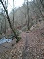
| + | Image:2015-01-17_50_7-4.jpg|path to the hash | ||
| + | Image:2015-01-17_50_7-5.jpg|proof | ||
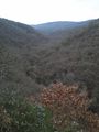
| + | Image:2015-01-17_50_7-6.jpg|a view from the hash | ||
| + | Image:2015-01-17_50_7-7.jpg|a hasher | ||
| + | Image:2015-01-17_50_7-8.jpg|a mark | ||
| + | Image:2015-01-17_50_7-9.jpg|another view from the hash | ||
| + | Image:2015-01-17_50_7-10.jpg|here I had to leave the valley... | ||
| + | Image:2015-01-17_50_7-11.jpg|and cross some rocks | ||
| + | Image:2015-01-17_50_7-12.jpg|at the top of the valley ... | ||
| + | Image:2015-01-17_50_7-13.jpg|is a bench | ||
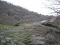
| + | Image:2015-01-17_50_7-14.jpg|rhine valley | ||
| + | Image:2015-01-17_50_7-15.jpg|Rheinbay | ||
</gallery> | </gallery> | ||
| Line 50: | Line 65: | ||
<!-- Add any achievement ribbons you earned below, or remove this section --> | <!-- Add any achievement ribbons you earned below, or remove this section --> | ||
| + | {{land geohash | ||
| − | + | | latitude = 50 | |
| − | + | | longitude = 7 | |
| − | + | | date = 2015-01-17 | |
| + | | name = DODO | ||
| + | }} | ||
| − | |||
| − | |||
| − | |||
| − | |||
| − | |||
| − | |||
[[Category:Expeditions]] | [[Category:Expeditions]] | ||
| − | |||
[[Category:Expeditions with photos]] | [[Category:Expeditions with photos]] | ||
| − | |||
| − | |||
| − | |||
| − | |||
| − | |||
[[Category:Coordinates reached]] | [[Category:Coordinates reached]] | ||
| − | + | {{location|DE|RP|GOA}} | |
| − | |||
| − | |||
| − | |||
| − | |||
| − | |||
| − | |||
| − | |||
| − | |||
| − | |||
| − | |||
| − | |||
| − | |||
| − | |||
| − | |||
| − | |||
| − | |||
| − | |||
Latest revision as of 02:26, 15 August 2019
| Sat 17 Jan 2015 in 50,7: 50.1844777, 7.6280638 geohashing.info google osm bing/os kml crox |
Location
In the forest between Rheinbay and Weiler at the slope of the Rhine.
Participants
Plans
I'll drive to Neuwied to visit my mother tomorrow, and with a detour of just 9 KM I can reach Rheinbay. From there it's only 1,5 KM to walk to the hash. Who am I to let such an opportunity slip? I hope to be there around 2 o'clock.
Expedition
I left home a little bit later than expected, and so I had no time to look for the route guidance system. So I had some difficulties to find Rheinbay at all. But after one very short detour and several insecurities I arrived at the start point of todays walking-tour: I parked the car next to the cemetery and walked into the field. After a short while I reached a ditch and walked along for a while, just 10 m above it. When another ditch came in from the other side the path went down to water level and I crossed a small bridge. Now I had to climb along a small path through the slope of the valley. The hashpoint was easy accessible located exactly at the top of the slope. I took some photos, left a small mark and returned to the former mentioned bridge. From there I continued my way through the valley. After a while my path led out of the valley and up again. Then I reached some rocks that were crossed by my path and at the top of them was a big bench. I paused for some minutes and continued, still going upwards, now along the slope of the Rhine river. I reached some lookout points with marvelous views down to the river before the way turned back to Rheinbay.
I continued my drive to my mother where I was welcomed with some cake, before we drove to a great dinner show in the evening.
Tracklog
5 km walk (and 10 KM detour by car, not logged)
Photos
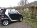
little car at the cemetery
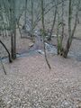
the "bridge"
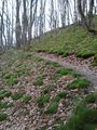
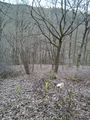
path to the hash
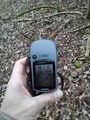
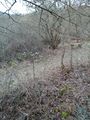
proof
a view from the hash
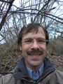
a hasher
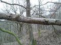
a mark
another view from the hash
here I had to leave the valley...
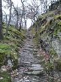
and cross some rocks
at the top of the valley ...
is a bench
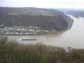
rhine valley
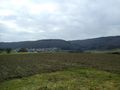
Rheinbay


Achievements
DODO earned the Land geohash achievement
|