Difference between revisions of "2015-01-18 50 8"
imported>DODO (→Tracklog) |
imported>DODO (→Achievements) |
||
| Line 52: | Line 52: | ||
{{#vardefine:ribbonwidth|800px}} | {{#vardefine:ribbonwidth|800px}} | ||
<!-- Add any achievement ribbons you earned below, or remove this section --> | <!-- Add any achievement ribbons you earned below, or remove this section --> | ||
| + | {{land geohash | ||
| + | | latitude = 50 | ||
| + | | longitude = 8 | ||
| + | | date = 2015-01-18 | ||
| + | | name = DODO | ||
| + | }} | ||
| − | + | {{consecutive geohash | |
| − | + | | count = 2 | |
| − | + | | latitude = 50 | |
| + | | longitude = 7 | ||
| + | | date = 2015-01-17 | ||
| + | | name = DODO | ||
| + | }} | ||
| − | |||
| − | |||
| − | |||
| − | |||
| − | |||
| − | |||
| − | |||
[[Category:Expeditions]] | [[Category:Expeditions]] | ||
| − | |||
[[Category:Expeditions with photos]] | [[Category:Expeditions with photos]] | ||
| − | |||
| − | |||
| − | |||
| − | |||
| − | |||
[[Category:Coordinates reached]] | [[Category:Coordinates reached]] | ||
| − | |||
| − | |||
| − | |||
| − | |||
| − | |||
| − | |||
| − | |||
| − | |||
| − | |||
| − | |||
| − | |||
| − | |||
| − | |||
| − | |||
| − | |||
| − | |||
| − | |||
| − | |||
Revision as of 20:34, 18 January 2015
| Sun 18 Jan 2015 in 50,8: 50.2551586, 8.3731073 geohashing.info google osm bing/os kml crox |
Location
On a field or a path near Niederems
Participants
Plans
I might visit Bad Camberg and/or Idstein on my way back home. Between these two towns lies the small village of Niederems, where I can reach todays hash by a small walk.
Expedition
I left my mothers home at 2 o'clock and instead of the shortest way on the left side of the Rhine I choose to drive along the motorway A3 on the right side. I left the motorway at Bad Camberg and had a short stop to visit this town (where I've never been before). After ten minutes in the town I think that I had a good enough impression and drove on to Niederems, a very small village in the valley of the Ems. My impression from google maps was a wide rural valley, but in reality the valley was quite steep and so I had to mount some hills again. After a short while I reached the hashpoint and took some pictures. I found no hint that there were any other hashers. So I was very surprised that I haven't been the only one there today (but to tell the truth I didn't leave any mark either).
I returned to my car quickly and had another stop in Idstein(where I haven't been before either), another town just 10 KM from the hashpoint and near the A3 again. Idstein was much bigger and much more interesting than Bad Camberg and had a castle and a lot of frame houses. After a while I continued my journey back home.
Tracklog
DODO: 3 KM walk and additional 30 KM detour by car
Photos
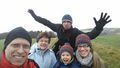
Coordinates reached. :-)

Achievements
DODO earned the Land geohash achievement
|
DODO earned the Consecutive geohash achievement
|