Difference between revisions of "2015-01-18 50 8"
imported>DODO (→Expedition) |
imported>FippeBot m (Location) |
||
| (9 intermediate revisions by 2 users not shown) | |||
| Line 1: | Line 1: | ||
| − | |||
| − | |||
| − | |||
| − | |||
| − | |||
| − | |||
| − | |||
| − | |||
| − | |||
| − | |||
{{meetup graticule | {{meetup graticule | ||
| lat=50 | | lat=50 | ||
| Line 15: | Line 5: | ||
}} | }} | ||
| − | |||
__NOTOC__ | __NOTOC__ | ||
== Location == | == Location == | ||
| − | |||
On a field or a path near Niederems | On a field or a path near Niederems | ||
== Participants == | == Participants == | ||
| − | + | * [[User:DODO|DODO]] | |
| − | + | ||
| − | [[User: | + | and, independantly |
| + | |||
| + | * [[User:QuarterCacher|QuarterCacher]] and [[User:M|M]] | ||
| + | * [[User:Mampfred|Mampfred]], [[User:LadyBB|LadyBB]] and [[User:EmmJay|EmmJay]] | ||
== Plans == | == Plans == | ||
| − | + | === DODO === | |
I might visit Bad Camberg and/or Idstein on my [[2015-01-17_50_7|way back home]]. Between these two towns lies the small village of Niederems, where I can reach todays hash by a small walk. | I might visit Bad Camberg and/or Idstein on my [[2015-01-17_50_7|way back home]]. Between these two towns lies the small village of Niederems, where I can reach todays hash by a small walk. | ||
== Expedition == | == Expedition == | ||
| − | + | === DODO === | |
I left my mothers home at 2 o'clock and instead of the shortest way on the left side of the Rhine I choose to drive along the motorway A3 on the right side. I left the motorway at Bad Camberg and had a short stop to visit this town (where I've never been before). After ten minutes in the town I think that I had a good enough impression and drove on to Niederems, a very small village in the valley of the Ems. My impression from google maps was a wide rural valley, but in reality the valley was quite steep and so I had to mount some hills [[2015-01-17_50_7|again]]. After a short while I reached the hashpoint and took some pictures. I found no hint that there were any other hashers. So I was very surprised that I haven't been the only one there today (but to tell the truth I didn't leave any mark either). | I left my mothers home at 2 o'clock and instead of the shortest way on the left side of the Rhine I choose to drive along the motorway A3 on the right side. I left the motorway at Bad Camberg and had a short stop to visit this town (where I've never been before). After ten minutes in the town I think that I had a good enough impression and drove on to Niederems, a very small village in the valley of the Ems. My impression from google maps was a wide rural valley, but in reality the valley was quite steep and so I had to mount some hills [[2015-01-17_50_7|again]]. After a short while I reached the hashpoint and took some pictures. I found no hint that there were any other hashers. So I was very surprised that I haven't been the only one there today (but to tell the truth I didn't leave any mark either). | ||
I returned to my car quickly and had another stop in Idstein(where I haven't been before either), another town just 10 KM from the hashpoint and near the A3 again. Idstein was much bigger and much more interesting than Bad Camberg and had a castle and a lot of frame houses. After a while I continued my journey back home. | I returned to my car quickly and had another stop in Idstein(where I haven't been before either), another town just 10 KM from the hashpoint and near the A3 again. Idstein was much bigger and much more interesting than Bad Camberg and had a castle and a lot of frame houses. After a while I continued my journey back home. | ||
| + | |||
| + | === The Rest === | ||
| + | It's been ages since we visited the last hash. So the group decided that it's a great day to do that again. We had a nice little walk and were totally unaware that Dodo is heading our way as well. Shame that we didn't meet :) | ||
== Tracklog == | == Tracklog == | ||
| − | + | DODO: [https://www.komoot.de/tour/4190265 3 KM walk] and additional 30 KM detour by car | |
== Photos == | == Photos == | ||
| − | + | ===QuarterCacher's photos=== | |
| − | + | <gallery perrow="6"> | |
| − | |||
| − | <gallery perrow=" | ||
| − | |||
Image:2015-01-18_50_8_QuarterCacher_1421583718887.jpg | Coordinates reached. :-) | Image:2015-01-18_50_8_QuarterCacher_1421583718887.jpg | Coordinates reached. :-) | ||
| + | </gallery> | ||
| + | ===DODOs photos=== | ||
| + | <gallery perrow="6"> | ||
| + | Image:2015-01-18_50_8-1.jpg | Bad Camberg | ||
| + | Image:2015-01-18_50_8-2.jpg | Niederems, already far below | ||
| + | Image:2015-01-18_50_8-3.jpg | the first view to the hash: its near the stance in the middle | ||
| + | Image:2015-01-18_50_8-4.jpg | the same stance seen from the hash | ||
| + | Image:2015-01-18_50_8-5.jpg | and the other direction | ||
| + | Image:2015-01-18_50_8-6.jpg | hasher with stupid grin (you know, it's the best I can do) | ||
| + | Image:2015-01-18_50_8-7.png | proof | ||
| + | Image:2015-01-18_50_8-8.jpg | another proof | ||
| + | Image:2015-01-18_50_8-9.jpg | this linden tree in Niederems is said to be more than 1000 years old | ||
| + | Image:2015-01-18_50_8-10.jpg | tower in Idstein | ||
| + | Image:2015-01-18_50_8-11.jpg | and castle in Idstein | ||
</gallery> | </gallery> | ||
| Line 51: | Line 56: | ||
{{#vardefine:ribbonwidth|800px}} | {{#vardefine:ribbonwidth|800px}} | ||
<!-- Add any achievement ribbons you earned below, or remove this section --> | <!-- Add any achievement ribbons you earned below, or remove this section --> | ||
| + | {{land geohash | ||
| + | | latitude = 50 | ||
| + | | longitude = 8 | ||
| + | | date = 2015-01-18 | ||
| + | | name = DODO | ||
| + | }} | ||
| − | + | {{consecutive geohash | |
| − | + | | count = 2 | |
| − | + | | latitude = 50 | |
| + | | longitude = 7 | ||
| + | | date = 2015-01-17 | ||
| + | | name = DODO | ||
| + | }} | ||
| − | + | {{OpenStreetMap achievement | |
| + | | latitude = 50 | ||
| + | | longitude = 8 | ||
| + | | date = 2015-01-18 | ||
| + | | OSMlink = 28575921 | ||
| + | | name = DODO | ||
| + | }} | ||
| − | |||
| − | |||
| − | |||
| − | |||
| − | |||
[[Category:Expeditions]] | [[Category:Expeditions]] | ||
| − | |||
[[Category:Expeditions with photos]] | [[Category:Expeditions with photos]] | ||
| − | |||
| − | |||
| − | |||
| − | |||
| − | |||
[[Category:Coordinates reached]] | [[Category:Coordinates reached]] | ||
| − | + | {{location|DE|HE|SWA}} | |
| − | |||
| − | |||
| − | |||
| − | |||
| − | |||
| − | |||
| − | |||
| − | |||
| − | |||
| − | |||
| − | |||
| − | |||
| − | |||
| − | |||
| − | |||
| − | |||
| − | |||
Latest revision as of 02:27, 15 August 2019
| Sun 18 Jan 2015 in 50,8: 50.2551586, 8.3731073 geohashing.info google osm bing/os kml crox |
Location
On a field or a path near Niederems
Participants
and, independantly
- QuarterCacher and M
- Mampfred, LadyBB and EmmJay
Plans
DODO
I might visit Bad Camberg and/or Idstein on my way back home. Between these two towns lies the small village of Niederems, where I can reach todays hash by a small walk.
Expedition
DODO
I left my mothers home at 2 o'clock and instead of the shortest way on the left side of the Rhine I choose to drive along the motorway A3 on the right side. I left the motorway at Bad Camberg and had a short stop to visit this town (where I've never been before). After ten minutes in the town I think that I had a good enough impression and drove on to Niederems, a very small village in the valley of the Ems. My impression from google maps was a wide rural valley, but in reality the valley was quite steep and so I had to mount some hills again. After a short while I reached the hashpoint and took some pictures. I found no hint that there were any other hashers. So I was very surprised that I haven't been the only one there today (but to tell the truth I didn't leave any mark either).
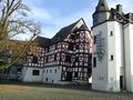
I returned to my car quickly and had another stop in Idstein(where I haven't been before either), another town just 10 KM from the hashpoint and near the A3 again. Idstein was much bigger and much more interesting than Bad Camberg and had a castle and a lot of frame houses. After a while I continued my journey back home.
The Rest
It's been ages since we visited the last hash. So the group decided that it's a great day to do that again. We had a nice little walk and were totally unaware that Dodo is heading our way as well. Shame that we didn't meet :)
Tracklog
DODO: 3 KM walk and additional 30 KM detour by car
Photos
QuarterCacher's photos

Coordinates reached. :-)

DODOs photos
Bad Camberg
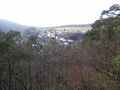
Niederems, already far below
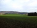
the first view to the hash: its near the stance in the middle
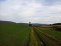
the same stance seen from the hash
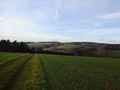
and the other direction

hasher with stupid grin (you know, it's the best I can do)
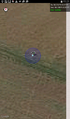
proof
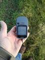
another proof
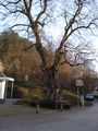
this linden tree in Niederems is said to be more than 1000 years old
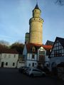
tower in Idstein
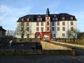
and castle in Idstein


Achievements
DODO earned the Land geohash achievement
|
DODO earned the Consecutive geohash achievement
|
DODO earned the OpenStreetMap achievement
|