Difference between revisions of "2015-01-19 39 -90"
imported>Mystrsyko (→Expedition) |
m (per Renaming Proposal) |
||
| (2 intermediate revisions by 2 users not shown) | |||
| Line 1: | Line 1: | ||
| − | |||
| − | |||
| − | |||
| − | |||
| − | |||
| − | |||
| − | |||
| − | |||
| − | |||
| − | |||
{{meetup graticule | {{meetup graticule | ||
| lat=39 | | lat=39 | ||
| Line 15: | Line 5: | ||
}} | }} | ||
| − | |||
__NOTOC__ | __NOTOC__ | ||
== Location == | == Location == | ||
| Line 28: | Line 17: | ||
== Expedition == | == Expedition == | ||
| − | |||
| − | + | [[File:2015-01-19 39 -90 drive.JPG|300px|thumb|left|DolphinTreasure driving us to the day's hash]] | |
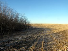
| − | + | [[File:2015-01-19 39 -90 flat.JPG|300px|thumb|right|Contrary to popular belief, Kansas is not flatter than Illinois]] | |
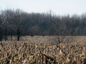
| + | [[File:2015-01-19 39 -90 deer2.JPG|300px|thumb|Whitetail deer fleeing the scene]] | ||
| + | Although I dislike burning gas to drive to hashpoint, I do make exceptions. For example, the month of January in the American midwest. I ([[User:Mystrsyko|Mystrsyko]]) was briefly considering riding my bike to this point, but 50+ miles in temperatures hovering around 36 degrees (2C) and needing to be back in time for work at 3pm, it was decided to drive instead. Also, [[User:Dolphintreasure|Dolphintreasure]] could go with then. | ||
| + | |||
| + | We grabbed our hashfox Collin and his big brother Todd, and headed out. We crossed through several small towns of less than 1000 residents, and although it is deep in the winter here, there were still a fair number of tractors and such driving around. Just north of Ashland, we turned off the main road and headed north to the hash. Along the way we passed a few small parking areas, which we later found out were pheasent hunting spots. Soon, it came time to turn off onto the one lane, semi-paved road that led past the field that contained the hashpoint. | ||
| + | |||
| + | We pulled up where the GPS said was the closest the road came and pulled off. The overwhelming flatness of the surrounding countryside was broken only by some short but steep hills here due to the small creek running just east of us. As I was getting GeohashDroid running, Dolphintreasure spotted some deer in the distance. It seemed they were heading for the hash point as well! | ||
| + | |||
| + | Pictures were taken and then we began the roughly 1/4 mile hike through the frozen, harvested corn field. We were nervous about being spotted by the local farmers, but luckily the trees around the creek provided a great deal of concealment. In fact, there wasn't a sign of humanity in sight, except of course for the field below our feet. As we neared the point, the land began to dip down towards the creek, and suddenly the deer came back into view. And just as quickly they bolted off into the woods! It would seem they had been waiting for us just below the crest of the hill. | ||
| + | |||
| + | I did the GPS hashdance, and got the "distance to point" down to 0.157 feet at one point, but for some reason my phone decided to do everything except take a screenshot. When it finally did, it was reading over 3 feet to the point, which was still in our margin of error. First hash of the year successfully found! Pictures were taken with our hashfoxes. I also had brought along my bike's speedometer because it had a temperature setting and I wanted to try for a [[Frozen Geohash]], but it picked up the body heat from our fingers and wouldn't read below 45F (7C). | ||
| + | |||
| + | Then suddenly, deer began sprinting past, about 40 feet from us. One big buck stopped and stared us down, which made Dolphintreasure nervous, thinking it might charge. But then it turned and ran off with the others over the hill to our west. We thought we might have heard coyotes, which worried us, especially if they had been pursuing the deer, and so we decided to bravely retreat back to the car. | ||
| + | |||
| + | Back across the frozen corn we hiked, encountering a third group of deer, which fled to the north. We also heard a quiet rumbling, which we thought might be a vehicle approaching, but nothing turned up. We piled ourselves back in the car and drove home very pleased with our morning geohashing. | ||
| + | |||
== Photos == | == Photos == | ||
| Line 37: | Line 40: | ||
Image:2012-##-## ## ## Alpha.jpg | Witty Comment | Image:2012-##-## ## ## Alpha.jpg | Witty Comment | ||
--> | --> | ||
| − | <gallery perrow=" | + | <gallery caption="Photo Gallery" widths="300px" heights="213px" perrow="3"> |
| + | Image:2015-01-19 39 -90 deer1.JPG|Are they geohashing too? | ||
| + | Image:2015-01-19 39 -90 dolphin.JPG|DolphinTreasure and Todd the hashfox | ||
| + | Image:2015-01-19 39 -90 syko.JPG|Mystrsyko and Collin the hashfox join them | ||
| + | Image:2015-01-19 39 -90 hashNE.JPG|From the hash looking east | ||
| + | Image:2015-01-19 39 -90 hashSW.JPG|From the hash looking west | ||
| + | Image:2015-01-19 39 -90 temp.JPG|Faulty temperature reading | ||
| + | Image:2015-01-19 39 -90 screenshot.png|Proof | ||
</gallery> | </gallery> | ||
== Achievements == | == Achievements == | ||
{{#vardefine:ribbonwidth|800px}} | {{#vardefine:ribbonwidth|800px}} | ||
| − | |||
| + | {{Graticule unlocked | ||
| − | + | | latitude = 39 | |
| − | + | | longitude = -90 | |
| − | + | | date = 2015-01-19 | |
| + | | name = Mystrsyko & DolphinTreasure | ||
| − | + | }} | |
| − | + | {{land geohash | |
| − | + | ||
| − | + | | latitude = 39 | |
| − | + | | longitude = -90 | |
| + | | date = 2015-01-19 | ||
| + | | name = Mystrsyko & DolphinTreasure | ||
| − | + | }} | |
| − | |||
| − | |||
| − | |||
| − | |||
| − | |||
| − | |||
| − | |||
| − | |||
| − | |||
| + | {{Minesweeper geohash | ||
| − | + | | graticule = Springfield, Illinois | |
| − | + | | ranknumber = 1 | |
| − | + | | w = true | |
| − | + | | name = Mystrsyko & DolphinTreasure | |
| − | |||
| − | |||
| − | |||
| − | |||
| − | + | }} | |
| − | |||
| − | |||
| − | |||
| − | |||
| − | + | [[Category:Expeditions]] | |
| + | [[Category:Expeditions with photos]] | ||
| + | [[Category:Coordinates reached]] | ||
| + | {{location|US|IL|CS}} | ||
Latest revision as of 05:06, 20 March 2024
| Mon 19 Jan 2015 in 39,-90: 39.9772974, -90.0252522 geohashing.info google osm bing/os kml crox |
Location
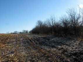
In a field near Cox Creek, north of Ashland, IL.
Participants
Plans
To go there!
Expedition


Although I dislike burning gas to drive to hashpoint, I do make exceptions. For example, the month of January in the American midwest. I (Mystrsyko) was briefly considering riding my bike to this point, but 50+ miles in temperatures hovering around 36 degrees (2C) and needing to be back in time for work at 3pm, it was decided to drive instead. Also, Dolphintreasure could go with then.
We grabbed our hashfox Collin and his big brother Todd, and headed out. We crossed through several small towns of less than 1000 residents, and although it is deep in the winter here, there were still a fair number of tractors and such driving around. Just north of Ashland, we turned off the main road and headed north to the hash. Along the way we passed a few small parking areas, which we later found out were pheasent hunting spots. Soon, it came time to turn off onto the one lane, semi-paved road that led past the field that contained the hashpoint.
We pulled up where the GPS said was the closest the road came and pulled off. The overwhelming flatness of the surrounding countryside was broken only by some short but steep hills here due to the small creek running just east of us. As I was getting GeohashDroid running, Dolphintreasure spotted some deer in the distance. It seemed they were heading for the hash point as well!
Pictures were taken and then we began the roughly 1/4 mile hike through the frozen, harvested corn field. We were nervous about being spotted by the local farmers, but luckily the trees around the creek provided a great deal of concealment. In fact, there wasn't a sign of humanity in sight, except of course for the field below our feet. As we neared the point, the land began to dip down towards the creek, and suddenly the deer came back into view. And just as quickly they bolted off into the woods! It would seem they had been waiting for us just below the crest of the hill.
I did the GPS hashdance, and got the "distance to point" down to 0.157 feet at one point, but for some reason my phone decided to do everything except take a screenshot. When it finally did, it was reading over 3 feet to the point, which was still in our margin of error. First hash of the year successfully found! Pictures were taken with our hashfoxes. I also had brought along my bike's speedometer because it had a temperature setting and I wanted to try for a Frozen Geohash, but it picked up the body heat from our fingers and wouldn't read below 45F (7C).
Then suddenly, deer began sprinting past, about 40 feet from us. One big buck stopped and stared us down, which made Dolphintreasure nervous, thinking it might charge. But then it turned and ran off with the others over the hill to our west. We thought we might have heard coyotes, which worried us, especially if they had been pursuing the deer, and so we decided to bravely retreat back to the car.
Back across the frozen corn we hiked, encountering a third group of deer, which fled to the north. We also heard a quiet rumbling, which we thought might be a vehicle approaching, but nothing turned up. We piled ourselves back in the car and drove home very pleased with our morning geohashing.
Photos
- Photo Gallery
Are they geohashing too?
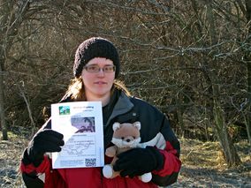
DolphinTreasure and Todd the hashfox
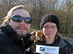
Mystrsyko and Collin the hashfox join them
From the hash looking east
From the hash looking west
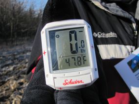
Faulty temperature reading
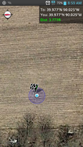
Proof


Achievements
Mystrsyko & DolphinTreasure earned the Graticule Unlocked Achievement
|
Mystrsyko & DolphinTreasure earned the Land geohash achievement
|
Mystrsyko & DolphinTreasure achieved level 1 of the Minesweeper Geohash achievement
|