Difference between revisions of "2015-01-20 49 8"
From Geohashing
imported>Q-Owl (Created page with "<!-- Christmas Hash|thumb|left -->{{meetup graticule | lat=49 | lon=8 | date=2015-01-20 }}__NOTOC__ == Location == In the west of w...") |
imported>FippeBot m (Location) |
||
| (7 intermediate revisions by 2 users not shown) | |||
| Line 1: | Line 1: | ||
| − | + | [[Image:2015-01-20 49 8 near.jpg | Near the hashpoint|thumb|left | |
| − | ]] | + | ]]{{meetup graticule |
| lat=49 | | lat=49 | ||
| lon=8 | | lon=8 | ||
| Line 22: | Line 22: | ||
== Expedition == | == Expedition == | ||
| − | + | Success: | |
| − | + | * I arrived at about 16:50 (15 min after sunset), | |
| − | Success: | + | * walked a little bit back and forth in tractor tracks to find the best position, |
| − | + | * marked the hp with a little piece of paper, | |
| + | * took some photos, | ||
| + | * smiled :-) | ||
| + | * returned to the car and drove home. | ||
== Photos == | == Photos == | ||
| − | |||
| − | |||
<gallery perrow="5" > | <gallery perrow="5" > | ||
| − | Image:2015-01-20 49 8 proof1.png | Proof | + | Image:2015-01-20 49 8 proof1.png | Proof 1 |
| − | Image:2015-01-20 49 8 hp.jpg | | + | Image:2015-01-20 49 8 proof2.png | Proof 2 |
| + | Image:2015-01-20 49 8 near.jpg | Near the hashpoint next to the railway | ||
| + | Image:2015-01-20 49 8 hp.jpg | Marked hashpoint and view to north | ||
Image:2015-01-20 49 8 e.jpg | East | Image:2015-01-20 49 8 e.jpg | East | ||
| + | Image:2015-01-20 49 8 se.jpg | Southeast | ||
Image:2015-01-20 49 8 s.jpg | South | Image:2015-01-20 49 8 s.jpg | South | ||
Image:2015-01-20 49 8 w.jpg | West | Image:2015-01-20 49 8 w.jpg | West | ||
| − | |||
Image:2015-01-20 49 8 grin.jpg | Smile | Image:2015-01-20 49 8 grin.jpg | Smile | ||
| − | </gallery | + | </gallery> |
<!-- | <!-- | ||
List of uploaded Files: | List of uploaded Files: | ||
| Line 56: | Line 59: | ||
| name = [[User:Q-Owl|Q-Owl]] | | name = [[User:Q-Owl|Q-Owl]] | ||
}} | }} | ||
| − | + | <!-- | |
| + | {{Easy_geohash | ||
| + | | latitude = 49 | ||
| + | | longitude = 8 | ||
| + | | date = 2015-01-20 | ||
| + | | name = [[User:Q-Owl|Q-Owl]] | ||
| + | | image = image name (optional) | ||
| + | }} | ||
| + | --> | ||
[[Category:Expeditions]] | [[Category:Expeditions]] | ||
[[Category:Coordinates reached]] | [[Category:Coordinates reached]] | ||
[[Category:Expeditions with photos]] | [[Category:Expeditions with photos]] | ||
| + | {{location|DE|HE|DA}} | ||
Latest revision as of 02:30, 15 August 2019

| Tue 20 Jan 2015 in 49,8: 49.7473503, 8.6047148 geohashing.info google osm bing/os kml crox |
Location
In the west of Alsbach at the eastern rim of the upper Rhine valley.
Participants
Plan
Todays hashpoint is not far from home. So I plan:
- Do a little detour on the way home.
- Drive to Alsbach-Sandwiese (little detour on the way home).
- Arrive about 17:00.
- Reach the hash point.
- Return home.
Expedition
Success:
- I arrived at about 16:50 (15 min after sunset),
- walked a little bit back and forth in tractor tracks to find the best position,
- marked the hp with a little piece of paper,
- took some photos,
- smiled :-)
- returned to the car and drove home.
Photos
Proof 1
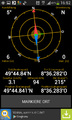
Proof 2
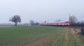
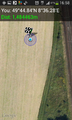
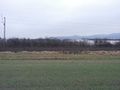
Near the hashpoint next to the railway
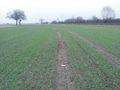
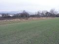
Marked hashpoint and view to north
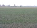
East
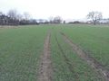
Southeast
South
West

Smile


Achievements
Q-Owl earned the Land geohash achievement
|