Difference between revisions of "2015-01-21 42 -78"
imported>Pedalpusher m (→Location: punctuation) |
imported>Pedalpusher (expedition summary) |
||
| Line 5: | Line 5: | ||
== Location == | == Location == | ||
| − | In the Boston Forest County Park, South of Hamburg | + | In the Boston Forest County Park, South of Hamburg, NY |
== Participants == | == Participants == | ||
| Line 13: | Line 13: | ||
== Expedition == | == Expedition == | ||
| + | The expedition went better than expected. The county is great with maintaining their parking areas and when I got there, the whole area was plowed. There was no concern about getting stuck today! | ||
| + | |||
| + | Getting out of the car, there was a wide path leading out in the direction I wanted to go. I couldn't go directly to the hash because cutting the corner would have me going over private (and posted) land. So I walked South about a half mile down this path where I met a snow-mobile trail that was now going the same way I needed to go(East). I followed that to a junction and left the trail to walk along the edge of the County forest. To the left I saw posted signs and to the right were the County Forest signs. | ||
| + | |||
| + | I finally made it to the hash after crossing a few frozen streams and it took a while today to do the GPS dance. Once I finally got it under 10 feet, I got my pictures and we headed back. While the high for today was under 32F, it was close enough that without a thermometer, I won't take a frozen hash. The Snowman Ribbon will also have to wait as the snow was hard from the warmer weather we had earlier in the week which softened everything and then the colder temps really harden the snow and make it crisp. | ||
| + | |||
| + | I have issued another Tale of Two challenge, this one for Boston as I was in the Boston Forest County Park and also in the Town of Boston. I'm very surprised no one had issued a Boston challenge for this until now! | ||
| + | |||
| + | Another note, This was the closest so far to a Déjà vu achievement. On [[2014-09-22 42 -78 | 2014-09-22]] I rode my bike down Feddick Rd which is the Western boundary for the park and about a half mile from where I parked. The hash is about 1 mile from that road and very close to the road that the earlier hash was next to. Google says the hashes are 2.1 miles apart. | ||
== Photos == | == Photos == | ||
| − | <gallery perrow=" | + | <gallery perrow="4"> |
| − | Image: | + | Image: 2015-01-21 ParkSign.jpg | The park signage. |
| − | Image: | + | Image: 2015-01-21 path.jpg | Nice hiking path, the dogs were happy to stretch their legs. |
| − | Image: | + | Image: 2015-01-21 SnowmobileMap.jpg | The snow-mobile junction and giant map. Apparently, there are snow-mobile trails all over the southern half of Erie County. |
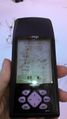
| − | Image: | + | Image: 2015-01-21 gps1.jpg | Finally got a good picture of the distance to the hash. |
| − | Image: | + | Image: 2015-01-21 gps2.jpg | No wonder it took a while, the satellite reception was poor. |
| − | Image: | + | Image: 2015-01-21 me.jpg | Standard stupid grin |
| − | Image: | + | Image: 2015-01-21 dogsAtHash.jpg | Bored dogs waiting for me to finish so they could run again. |
| − | Image: | + | Image: 2015-01-21 signsOfRodent.jpg| On the way back, I came across evidence of a chipmunk or mouse that came out of this hole in the snow to eat a pine-cone. |
</gallery> | </gallery> | ||
== Ribbons == | == Ribbons == | ||
| − | + | {{land geohash | |
| latitude = 42 | | latitude = 42 | ||
| longitude = -78 | | longitude = -78 | ||
| − | | date = 2015- | + | | date = 2015-01-21 |
}} | }} | ||
| − | |||
| − | [[Category: | + | {{A Tale of Two Hashes challenge |
| + | | latitude = 42 | ||
| + | | longitude = -78 | ||
| + | | date = 2015-01-21 | ||
| + | | name = Pedalpusher | ||
| + | | place = Boston | ||
| + | | image = 2015-01-21 ParkSign.jpg | ||
| + | }} | ||
| + | |||
| + | |||
| + | [[Category:Expeditions]] | ||
| + | [[Category:Coordinates reached]] | ||
| + | [[Category:Expeditions with dogs]] | ||
Revision as of 21:22, 21 January 2015
| Wed 21 Jan 2015 in 42,-78: 42.6232245, -78.7734263 geohashing.info google osm bing/os kml crox |
Plans
This is a close hash so the plan is to take the dogs out for a run around lunchtime so we still have light for getting to the hash. The concern again will be the snowbanks. If there is nowhere to park, it will end up like my last expedition. I have hope though because there is a driveway to a parking area on the North side and if the driveway is plowed or even if the road shoulder is clear, it should be ok. Then, it will just be about a mile hike through the woods to the hash.
Location
In the Boston Forest County Park, South of Hamburg, NY
Participants
- Pedalpusher (talk)
- Simon the dog
- Myka the dog
Expedition
The expedition went better than expected. The county is great with maintaining their parking areas and when I got there, the whole area was plowed. There was no concern about getting stuck today!
Getting out of the car, there was a wide path leading out in the direction I wanted to go. I couldn't go directly to the hash because cutting the corner would have me going over private (and posted) land. So I walked South about a half mile down this path where I met a snow-mobile trail that was now going the same way I needed to go(East). I followed that to a junction and left the trail to walk along the edge of the County forest. To the left I saw posted signs and to the right were the County Forest signs.
I finally made it to the hash after crossing a few frozen streams and it took a while today to do the GPS dance. Once I finally got it under 10 feet, I got my pictures and we headed back. While the high for today was under 32F, it was close enough that without a thermometer, I won't take a frozen hash. The Snowman Ribbon will also have to wait as the snow was hard from the warmer weather we had earlier in the week which softened everything and then the colder temps really harden the snow and make it crisp.
I have issued another Tale of Two challenge, this one for Boston as I was in the Boston Forest County Park and also in the Town of Boston. I'm very surprised no one had issued a Boston challenge for this until now!
Another note, This was the closest so far to a Déjà vu achievement. On 2014-09-22 I rode my bike down Feddick Rd which is the Western boundary for the park and about a half mile from where I parked. The hash is about 1 mile from that road and very close to the road that the earlier hash was next to. Google says the hashes are 2.1 miles apart.
Photos
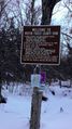
The park signage.
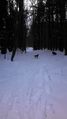
Nice hiking path, the dogs were happy to stretch their legs.
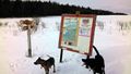
The snow-mobile junction and giant map. Apparently, there are snow-mobile trails all over the southern half of Erie County.
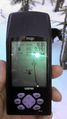
Finally got a good picture of the distance to the hash.
No wonder it took a while, the satellite reception was poor.

Standard stupid grin
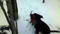
Bored dogs waiting for me to finish so they could run again.

On the way back, I came across evidence of a chipmunk or mouse that came out of this hole in the snow to eat a pine-cone.


Ribbons
This user earned the Land geohash achievement
|

