Difference between revisions of "2015-02-02 49 8"
imported>DODO (→Tracklog) |
imported>FippeBot m (Location) |
||
| (7 intermediate revisions by one other user not shown) | |||
| Line 39: | Line 39: | ||
It's a little bit hard to proof my visit as there is absolutely no gps-reception in the tunnel. So I can just proof that I've been on the train, and hope that google shows the course of the tunnel right. Well, in this case that has to be good enough for me. | It's a little bit hard to proof my visit as there is absolutely no gps-reception in the tunnel. So I can just proof that I've been on the train, and hope that google shows the course of the tunnel right. Well, in this case that has to be good enough for me. | ||
| + | |||
| + | Oh, and I've been in this tunnel several times before. Best proof is the tracklog from [[2014-09-17_49_8]]. | ||
== Tracklog == | == Tracklog == | ||
| Line 48: | Line 50: | ||
Image:2012-##-## ## ## Alpha.jpg | Witty Comment | Image:2012-##-## ## ## Alpha.jpg | Witty Comment | ||
--> | --> | ||
| − | <gallery perrow=" | + | <gallery perrow="6"> |
| + | Image:2015-02-02_49_8-1.jpg | The station Mannheim-Seckenheim. The snow-white mountain in the background accommodates todays hash | ||
| + | Image:2015-02-02_49_8-2.jpg | I paid 2,90 € for one direction | ||
| + | Image:2015-02-02_49_8-3.jpg | in this train | ||
| + | Image:2015-02-02_49_8-4.jpg | the closest view to the hashmountain | ||
| + | Image:2015-02-02_49_8-5.jpg | the far side of the tunnel next to the station Heidelberg-Altstadt | ||
| + | Image:2015-02-02_49_8-6.jpg | and I paid 2,90 € for the other direction. | ||
</gallery> | </gallery> | ||
| Line 54: | Line 62: | ||
{{#vardefine:ribbonwidth|800px}} | {{#vardefine:ribbonwidth|800px}} | ||
<!-- Add any achievement ribbons you earned below, or remove this section --> | <!-- Add any achievement ribbons you earned below, or remove this section --> | ||
| + | {{going deep geohash | ||
| + | | latitude = 49 | ||
| + | | longitude = 8 | ||
| + | | date = 2015-02-02 | ||
| + | | name = DODO | ||
| + | | image = 2015-02-02_49_8-5.jpg | ||
| + | }} | ||
| + | |||
| + | {{Admit One geohash | ||
| + | | latitude = 49 | ||
| + | | longitude = 8 | ||
| + | | date = 2015-02-02 | ||
| + | | name = DODO | ||
| + | | price = 2 * 2,90 € | ||
| + | | venue = train from Mannheim-Seckenheim to Heidelberg-Altstadt | ||
| + | | image = 2015-02-02_49_8-6.jpg | ||
| + | }} | ||
| + | {{Déjà vu geohash | ||
| − | + | | latitude = 49 | |
| − | + | | longitude = 8 | |
| − | [[ | + | | date = 2015-02-02 |
| + | | olddate = [[2014-09-17_49_8|2014-09-17]] | ||
| + | | name = DODO | ||
| + | }} | ||
| − | + | Of course I met a lot of strangers at the geohash, but none of them knew. | |
| − | + | And unfortunatly ilpadre (or anyone else) wasn't at the geohash at 5 pm to obtain a stacking achievement. But three brand new achievements on one day is satisfying enough. | |
| − | |||
| − | |||
| − | |||
| − | |||
[[Category:Expeditions]] | [[Category:Expeditions]] | ||
| − | |||
[[Category:Expeditions with photos]] | [[Category:Expeditions with photos]] | ||
| − | |||
| − | |||
| − | |||
| − | |||
| − | |||
[[Category:Coordinates reached]] | [[Category:Coordinates reached]] | ||
| − | + | {{location|DE|BW|HD|city=true}} | |
| − | |||
| − | |||
| − | |||
| − | |||
| − | |||
| − | |||
| − | |||
| − | |||
| − | |||
| − | |||
| − | |||
| − | |||
| − | |||
| − | |||
| − | |||
| − | |||
| − | |||
Latest revision as of 02:37, 15 August 2019
| Mon 2 Feb 2015 in 49,8: 49.4033898, 8.7009610 geohashing.info google osm bing/os kml crox |
Location
On the way from Heidelberg to the Königstuhl (kings chair), the local mountain. Or - to be precise - far below it.
Participants
Plans
Todays hashpoint was pretty close to Heidelberg, so I hoped that ilpadre would announce his coming and I could finally meet him. On the other hand, I had no idea when I can leave the office and so I can't predict, when I can be there. So I gave up meeting anybody and decided not to go (although I've already prepared my gps-device at home).
Tomorrows hashpoint would be my first anniversary and so I had a close look to it. But although it's not far from home I won't make it as I have hardly any time tomorrow and it looks like the point isn't accessible anyway(the second closest hashpoint (48,8) is inside of a house and not accessibleat all and the third closest is a more than 100 KM drive). So I had a closer look at this one. "Oh, that's funny, there's a high voltage power supply line just at the hashpoint on google maps. ... a power supply line on google maps? Since when does google show power supply lines on its maps? Hey, that's not a power supply line but the railway line from Heidelberg Weststadt/Südstadt to Heidelberg Altstadt that take course in a tunnel just exactly under the hashpoint. Well, could I?"
So, here's the plan: drive to the closest railway station from the office at that line (Mannheim-Seckenheim), enter the train, ride to Heidelberg-Altstadt, leave the train, take the next one in the opposite direction, visit the hashpoint once again and drive home.
Expedition
Well, everything went as planned. I could leave the office pretty early and reached the station Mannheim-Seckenheim at 16:30, so I had plenty of time to reach the 16:44 train. I reached Heidelberg-Altstadt at 17:05 and had to wait there until 17:27 to go back to Mannheim-Seckenheim. So I had a short walk into the city but didn't get very far.
It's a little bit hard to proof my visit as there is absolutely no gps-reception in the tunnel. So I can just proof that I've been on the train, and hope that google shows the course of the tunnel right. Well, in this case that has to be good enough for me.
Oh, and I've been in this tunnel several times before. Best proof is the tracklog from 2014-09-17_49_8.
Tracklog
33KM train and 11 KM by car (not recorded). There is no reception on the part between Heidelberg Weststadt/Südstadt and Heidelberg Altstadt, so the straight line is not really the way the train took.
Photos
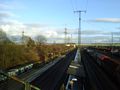
The station Mannheim-Seckenheim. The snow-white mountain in the background accommodates todays hash
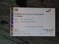
I paid 2,90 € for one direction
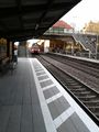
in this train
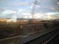
the closest view to the hashmountain
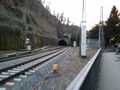
the far side of the tunnel next to the station Heidelberg-Altstadt
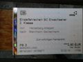
and I paid 2,90 € for the other direction.


Achievements
DODO earned the Going deep geohash achievement
|

DODO earned the Déjà Vu Geohash Achievement
|
Of course I met a lot of strangers at the geohash, but none of them knew.
And unfortunatly ilpadre (or anyone else) wasn't at the geohash at 5 pm to obtain a stacking achievement. But three brand new achievements on one day is satisfying enough.