Difference between revisions of "2015-02-08 49 9"
imported>Danatar (backbone) |
imported>Danatar (Report!) |
||
| Line 8: | Line 8: | ||
== Location == | == Location == | ||
| − | Today's location is in the forest behind the Waldfriedhof (forest cemetery) of Würzburg, near the "peak" of the ''Unglücksberg'' (Mount Misfortune/Mount Bad Luck), at an elevation of about 328 m. | + | Today's location is in the forest behind the ''Waldfriedhof'' (forest cemetery) of Würzburg, near the "peak" of the ''Unglücksberg'' (Mount Misfortune/Mount Bad Luck), at an elevation of about 328 m. |
Country: Germany; state: Bayern (Bavaria, EU:DE:BY); administrative region: Unterfranken; district: Würzburg city district | Country: Germany; state: Bayern (Bavaria, EU:DE:BY); administrative region: Unterfranken; district: Würzburg city district | ||
| − | Weather: Sunny, | + | Weather: Sunny, cold. |
| Line 18: | Line 18: | ||
===[[User:Danatar|Danatar]]=== | ===[[User:Danatar|Danatar]]=== | ||
| + | I was in Würzburg for the weekend and this hashpoint fell in a nice distance from the place I was staying. The weather was nice and I had no plans for the morning, I took this opportunity for a walk in the forest. I thought about taking the tramway for part of the route but I would have had to wait almost as long as it would take me to walk, so I walked. I crossed the Main, then I followed the tramway route until I reached the ''Steinbachtal'' valley. From there I had to go uphill towards the ''Waldfriedhof'', but left the road in favor of a smaller track. The weather was cold but it got quite warm under my clothes. The last part of the route went along forest tracks that were covered in a thin layer of snow. Near the hashpoint I left the track and walked the last meters to the spot. | ||
*Hashpoint reached on Mount Misfortune. So far everything went fine. -- [[User:Danatar|Danatar]] ([[User talk:Danatar|talk]]) [http://www.openstreetmap.org/?lat=49.76013906&lon=9.90819370&zoom=16&layers=B000FTF @49.7601,9.9082] 11:12, 8 February 2015 (CET) | *Hashpoint reached on Mount Misfortune. So far everything went fine. -- [[User:Danatar|Danatar]] ([[User talk:Danatar|talk]]) [http://www.openstreetmap.org/?lat=49.76013906&lon=9.90819370&zoom=16&layers=B000FTF @49.7601,9.9082] 11:12, 8 February 2015 (CET) | ||
| − | |||
| − | + | ||
| + | After taking the usual pictures I built a marker, then I started to walk back. On the return route I went across the ''Waldfriedhof'', then down the hill. I crossed the Main, then walked along it back to the place I was staying. I had enough time to rest my legs for a moment before I met a friend over lunch. | ||
<gallery> | <gallery> | ||
| − | File:2015-02- | + | File:2015-02-08_49_9_festung.jpg|Festung Marienberg Würzburg |
| + | File:2015-02-08_49_9_weg1.jpg|walking through the forest | ||
| + | File:2015-02-08_49_9_weg2.jpg|walking through the forest | ||
| + | File:2015-02-08_49_9_gps.jpg|GPS | ||
| + | File:2015-02-08_49_9_spot.jpg|the hashpoint | ||
| + | File:2015-02-08_49_9_hp.jpg|coordinates reached | ||
| + | File:2015-02-08_49_9_pano.jpg|panorama | ||
| + | File:2015-02-08_49_9_marker.jpg|marker | ||
| + | File:2015-02-08_49_9_friedhof.jpg|cemetery | ||
</gallery> | </gallery> | ||
| Line 36: | Line 45: | ||
[[Category:Expeditions with photos]] | [[Category:Expeditions with photos]] | ||
[[Category:Coordinates reached]] | [[Category:Coordinates reached]] | ||
| − | [[Category:Danatar | + | [[Category:Danatar]] |
| − | |||
Revision as of 03:34, 19 February 2015
| Sun 8 Feb 2015 in Würzburg: 49.7601862, 9.9082210 geohashing.info google osm bing/os kml crox |
Location
Today's location is in the forest behind the Waldfriedhof (forest cemetery) of Würzburg, near the "peak" of the Unglücksberg (Mount Misfortune/Mount Bad Luck), at an elevation of about 328 m.
Country: Germany; state: Bayern (Bavaria, EU:DE:BY); administrative region: Unterfranken; district: Würzburg city district
Weather: Sunny, cold.
Expedition
Danatar
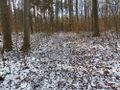
I was in Würzburg for the weekend and this hashpoint fell in a nice distance from the place I was staying. The weather was nice and I had no plans for the morning, I took this opportunity for a walk in the forest. I thought about taking the tramway for part of the route but I would have had to wait almost as long as it would take me to walk, so I walked. I crossed the Main, then I followed the tramway route until I reached the Steinbachtal valley. From there I had to go uphill towards the Waldfriedhof, but left the road in favor of a smaller track. The weather was cold but it got quite warm under my clothes. The last part of the route went along forest tracks that were covered in a thin layer of snow. Near the hashpoint I left the track and walked the last meters to the spot.
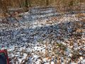
- Hashpoint reached on Mount Misfortune. So far everything went fine. -- Danatar (talk) @49.7601,9.9082 11:12, 8 February 2015 (CET)
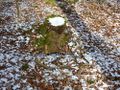
After taking the usual pictures I built a marker, then I started to walk back. On the return route I went across the Waldfriedhof, then down the hill. I crossed the Main, then walked along it back to the place I was staying. I had enough time to rest my legs for a moment before I met a friend over lunch.

Festung Marienberg Würzburg
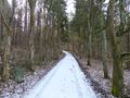
walking through the forest
walking through the forest

GPS
the hashpoint

coordinates reached

panorama
marker
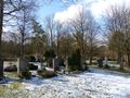
cemetery


tracklog
will follow