Difference between revisions of "2015-02-11 47 -122"
From Geohashing
imported>Thomcat ([live picture] North [http://www.openstreetmap.org/?lat=47.72381388&lon=-122.15010713&zoom=16&layers=B000FTF @47.7238,-122.1501]) |
imported>Thomcat ([live picture] [http://www.openstreetmap.org/?lat=47.71657296&lon=-122.15369742&zoom=16&layers=B000FTF @47.7166,-122.1537]) |
||
| Line 34: | Line 34: | ||
Image:2015-02-11_47_-122_thomcat_1423697836690.jpg | North [http://www.openstreetmap.org/?lat=47.72381388&lon=-122.15010713&zoom=16&layers=B000FTF @47.7238,-122.1501] | Image:2015-02-11_47_-122_thomcat_1423697836690.jpg | North [http://www.openstreetmap.org/?lat=47.72381388&lon=-122.15010713&zoom=16&layers=B000FTF @47.7238,-122.1501] | ||
| + | |||
| + | Image:2015-02-11_47_-122_thomcat_1423698808815.jpg | [http://www.openstreetmap.org/?lat=47.71657296&lon=-122.15369742&zoom=16&layers=B000FTF @47.7166,-122.1537] | ||
</gallery> | </gallery> | ||
Revision as of 23:54, 11 February 2015
| Wed 11 Feb 2015 in Seattle: 47.7237989, -122.1507513 geohashing.info google osm bing/os kml crox |
Location
A wooded hillside, south of Chateau Ste Michelle winery and west of the Sammamish river.
Participants
Plans
Visit sometime in the early afternoon, after work.
Expedition
Tracklog
Photos
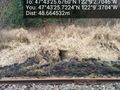
Hashpoint 48 m ahead @47.7238,-122.1501
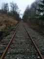
South @47.7238,-122.1501
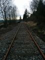
North @47.7238,-122.1501


Achievements