Difference between revisions of "2015-02-14 54 -2"
From Geohashing
imported>Angel (I'll go check the achievements, then be back to add if there's any relevant ones) |
imported>Angel m (oops) |
||
| Line 2: | Line 2: | ||
[[Image:{{{image|2015-02-14_54_-2_angel_1423936168406.jpg}}}|thumb|left]] | [[Image:{{{image|2015-02-14_54_-2_angel_1423936168406.jpg}}}|thumb|left]] | ||
| − | |||
| − | |||
| − | |||
| − | |||
{{meetup graticule | {{meetup graticule | ||
| lat=54 | | lat=54 | ||
Revision as of 12:57, 16 February 2015

| Sat 14 Feb 2015 in 54,-2: 54.0697436, -2.8113111 geohashing.info google osm bing/os kml crox |
Location
Beside the Lancaster canal, on the path. An easy place to reach.
Participants
Just Angel today.
Plans
Get up early, walk up the canal, then back into town for lunch. Maybe go out again later in case other people arrive at Meetup Time.
Expedition
- Feeling sick, feeling dizzy. This should have been an easy one, but having only just got out of bed makes it a challenge. -- Angel (talk) @54.0311,-2.7943 10:59, 14 February 2015 (EST)
- Finally left the house at some time after 3, I think.
- Reached the hash around sunset. Massive construction works, they're building a bridge over the canal right at the hash point.
- A good omen at last: the canal path has a wiggly detour, but comes within range of the hash!
- Tried to go back by road, there's a path across the site, but the gate onto the road was padlocked. So ended up needing to use my phone as a torch to make sure I didn't fall in the canal on the way home.
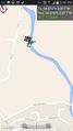
Tracklog
Endomondo tracklog from my phone
Photos
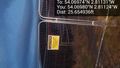
View from the hash... as far as I can tell, the exact point might be here, or might be on the closed part of the path
10 feet away; best I can get @54.0697,-2.8113
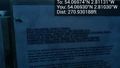
270 feet away, a diversion sign. Thought I'd failed! @54.0693,-2.8103
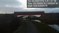
I guess this is where the new motorway is going to cross the canal :S @54.0690,-2.8092


