Difference between revisions of "2015-02-25 44 11"
imported>LucaPost (entered basic categories) |
imported>LucaPost (categories fix) |
||
| Line 62: | Line 62: | ||
<!-- ==REQUEST FOR TWITTER BOT== Please leave either the New report or the Expedition planning category in as long as you work on it. This helps the twitter bot a lot with announcing the right outcome at the right moment. --> | <!-- ==REQUEST FOR TWITTER BOT== Please leave either the New report or the Expedition planning category in as long as you work on it. This helps the twitter bot a lot with announcing the right outcome at the right moment. --> | ||
| − | |||
| − | |||
| − | |||
| − | |||
| − | |||
| − | |||
| − | |||
[[Category:Expeditions]] | [[Category:Expeditions]] | ||
[[Category:Expeditions with photos]] | [[Category:Expeditions with photos]] | ||
[[Category:Coordinates reached]] | [[Category:Coordinates reached]] | ||
Revision as of 11:33, 25 February 2015
| Wed 25 Feb 2015 in 44,11: 44.3887025, 11.4125312 geohashing.info google osm bing/os kml crox |
Location
Right on the ridge between Zena valley and Idice valley
Participants
Plans
This looked like an easy expedition, being just a few kilometers out of Bologna urban area, along a road where I often go biking in the summer.
Hence the plan was for a quick before-work detour but, because of the rain and a road landslide, it turned into quite a challenge; I guess it counts as a significative first-ever geoHash -I still have to browse for proper geohash categories and achievements...
Expedition
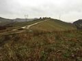
After driving to the road landslide I parked and decided to try by foot, all in all it turned out to be a one-hour walk on steep and muddy hills, under light rain; luckily I have extra shoes, socks and pants in the car trunk!
Tracklog
Photos
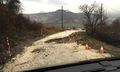
ooppps road landslide, let's walk
WAit me there, Car
- 2015-02-25 44 11 3.JPG
Witty Comment
- 2015-02-25 44 11 4.JPG
Witty Comment
- 2015-02-25 44 11 5.JPG
Witty Comment
- 2015-02-25 44 11 6.JPG
Witty Comment
- 2015-02-25 44 11 7.JPG
Witty Comment
- 2015-02-25 44 11 8.JPG
Witty Comment
- 2015-02-25 44 11 9.JPG
Witty Comment
- 2015-02-25 44 11 10.JPG
Witty Comment
- 2015-02-25 44 11 11.JPG
Witty Comment
- 2015-02-25 44 11 12.JPG
Witty Comment
- 2015-02-25 44 11 13.JPG
Witty Comment
- 2015-02-25 44 11 14.JPG
Witty Comment
- 2015-02-25 44 11 15.JPG
Witty Comment

