Difference between revisions of "2015-02-28 41 -93"
From Geohashing
imported>Trenchcoat (An expedition message sent via Geohash Droid for Android.) |
imported>FippeBot m (Location) |
||
| (7 intermediate revisions by 2 users not shown) | |||
| Line 21: | Line 21: | ||
== Participants == | == Participants == | ||
| − | + | [[User:Trenchcoat|Trenchcoat]] and three or four drag-alongs | |
| − | |||
| − | |||
== Plans == | == Plans == | ||
<!-- what were the original plans --> | <!-- what were the original plans --> | ||
| Line 38: | Line 36: | ||
--> | --> | ||
<gallery perrow="5"> | <gallery perrow="5"> | ||
| + | |||
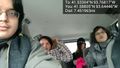
| + | Image:2015-02-28_41_-93_Trenchcoat_1425147756788.jpg | Getting ready to go. [http://www.openstreetmap.org/?lat=41.58830969&lon=-93.64028152&zoom=16&layers=B000FTF @41.5883,-93.6403] | ||
| + | |||
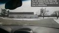
| + | Image:2015-02-28_41_-93_Trenchcoat_-1.jpg | Got our last member. [http://www.openstreetmap.org/?lat=41.58805171&lon=-93.64445803&zoom=16&layers=B000FTF @41.5881,-93.6445] | ||
| + | |||
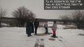
| + | Image:2015-02-28_41_-93_Trenchcoat_1425150788155.jpg | Waterworks Park. [http://www.openstreetmap.org/?lat=41.56857077&lon=-93.65274568&zoom=16&layers=B000FTF @41.5686,-93.6527] | ||
| + | |||
| + | Image:2015-02-28_41_-93_Trenchcoat_1425150951134.jpg | The frozen river. [http://www.openstreetmap.org/?lat=41.56074637&lon=-93.67142031&zoom=16&layers=B000FTF @41.5607,-93.6714] | ||
| + | |||
| + | Image:2015-02-28_41_-93_Trenchcoat_1425153233623.jpg | Failed due to swampland. [http://www.openstreetmap.org/?lat=41.52677022&lon=-93.76611125&zoom=16&layers=B000FTF @41.5268,-93.7661] | ||
</gallery> | </gallery> | ||
| Line 45: | Line 53: | ||
| − | |||
| − | |||
| − | |||
| − | |||
| − | |||
| − | |||
| − | |||
| − | |||
| − | |||
| − | |||
| − | |||
| − | |||
[[Category:Expeditions]] | [[Category:Expeditions]] | ||
| − | |||
[[Category:Expeditions with photos]] | [[Category:Expeditions with photos]] | ||
| − | |||
| − | |||
| − | |||
| − | |||
| − | |||
| − | |||
| − | |||
| − | |||
| − | |||
[[Category:Coordinates not reached]] | [[Category:Coordinates not reached]] | ||
| − | |||
| − | |||
[[Category:Not reached - Mother Nature]] | [[Category:Not reached - Mother Nature]] | ||
| − | + | {{location|US|IA|PK}} | |
| − | |||
| − | |||
| − | |||
| − | |||
| − | |||
| − | |||
| − | |||
| − | |||
| − | |||
| − | |||
Latest revision as of 02:52, 15 August 2019
| Sat 28 Feb 2015 in 41,-93: 41.5330389, -93.7681674 geohashing.info google osm bing/os kml crox |
Location
Participants
Trenchcoat and three or four drag-alongs
Plans
Expedition
Tracklog
Photos

Getting ready to go. @41.5883,-93.6403
Got our last member. @41.5881,-93.6445
Waterworks Park. @41.5686,-93.6527
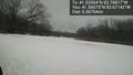
The frozen river. @41.5607,-93.6714
Failed due to swampland. @41.5268,-93.7661


