Difference between revisions of "2015-03-05 45 9"
imported>Thomcat ([live] Returning to the hotel. Successo!) |
imported>Thomcat (Success, story) |
||
| Line 18: | Line 18: | ||
== Expedition == | == Expedition == | ||
| − | + | Wednesday night I went for a quick scoping expedition, heading down to the San Donato station at the end of the M2 line. The ticket and inquiries window was closed, but I could see where I would need to catch the bus. A 48 hour bus pass can be quite useful! Unfortunately, I was caught by a cloud burst on the way home, just when I stopped at a local Pizzeria. | |
| + | Thursday morning broke bright, sunny and clear - amazing how a little cloudburst can clear the air! I took first a local bus, then metro to the same spot I was the previous night. The cashier at the ticket window helpfully pointed out to me (and his English was better than my Italian) that I should take the 8:05 bus, a local which stopped at my desired location. | ||
| + | |||
| + | This bus ride was relatively quick, as most of the traffic was coming into the city for an ordinary work day. So quick, in fact, that once I realized I would need a stop we were already upon it! I signaled anyhow and took the next stop, half a kilometer further away. No matter - this hash point could be approached from the east as well as from the west. | ||
| + | |||
| + | Crossing the road, I entered the field east of the location, which contained the remains of harvested corn. Heading west, I then came to an irrigation ditch, with a helpful crossing point (a sluice gate for controlling the flow). Crossing that, I entered the larger field which contained the hashpoint. | ||
| + | |||
| + | This field was turned earth, not planted, but ready. Slightly muddy due to last night's rainfall, but nothing I couldn't hike through. I kept to the edge until I reached the north-south level, then headed straight west. The geohashpoint was found easily, with a small hashdance on the muddy earth required for best accuracy. I snapped a few more pictures and continued west, to join the tractor track and eventually the road. | ||
| + | |||
| + | I found the bus back to Milano easily, but the trip back took three times as long. Apparently the commute doesn't end at 9 am. While on the bus I contemplated various photographs and sent a final message to the wiki... | ||
*Returning to the hotel. Successo! -- [[User:Thomcat|Thomcat]] ([[User talk:Thomcat|talk]]) [http://www.openstreetmap.org/?lat=45.42904156&lon=9.30756610&zoom=16&layers=B000FTF @45.4290,9.3076] 09:13, 5 March 2015 (CET) | *Returning to the hotel. Successo! -- [[User:Thomcat|Thomcat]] ([[User talk:Thomcat|talk]]) [http://www.openstreetmap.org/?lat=45.42904156&lon=9.30756610&zoom=16&layers=B000FTF @45.4290,9.3076] 09:13, 5 March 2015 (CET) | ||
| + | |||
== Tracklog == | == Tracklog == | ||
<!-- if your GPS device keeps a log, you may post a link here --> | <!-- if your GPS device keeps a log, you may post a link here --> | ||
| Line 54: | Line 64: | ||
<!-- Add any achievement ribbons you earned below, or remove this section --> | <!-- Add any achievement ribbons you earned below, or remove this section --> | ||
| − | |||
| − | |||
| − | |||
| − | |||
[[Category:Expeditions]] | [[Category:Expeditions]] | ||
| − | |||
[[Category:Expeditions with photos]] | [[Category:Expeditions with photos]] | ||
| − | |||
| − | |||
| − | |||
| − | |||
| − | |||
[[Category:Coordinates reached]] | [[Category:Coordinates reached]] | ||
| − | |||
| − | |||
| − | |||
| − | |||
| − | |||
| − | |||
| − | |||
| − | |||
| − | |||
| − | |||
| − | |||
| − | |||
| − | |||
| − | |||
| − | |||
| − | |||
| − | |||
| − | |||
Revision as of 10:01, 5 March 2015
| Thu 5 Mar 2015 in Milano: 45.4277491, 9.3520480 geohashing.info google osm bing/os kml crox |
Location
On crop land just south of Vigliano, which is just east of Milano.
Participants
Plans
Early morning visit, assuming the bus schedule can be worked out. May visit the eastern end of the M3 line on Wednesday to explore those options.
Expedition
Wednesday night I went for a quick scoping expedition, heading down to the San Donato station at the end of the M2 line. The ticket and inquiries window was closed, but I could see where I would need to catch the bus. A 48 hour bus pass can be quite useful! Unfortunately, I was caught by a cloud burst on the way home, just when I stopped at a local Pizzeria.
Thursday morning broke bright, sunny and clear - amazing how a little cloudburst can clear the air! I took first a local bus, then metro to the same spot I was the previous night. The cashier at the ticket window helpfully pointed out to me (and his English was better than my Italian) that I should take the 8:05 bus, a local which stopped at my desired location.
This bus ride was relatively quick, as most of the traffic was coming into the city for an ordinary work day. So quick, in fact, that once I realized I would need a stop we were already upon it! I signaled anyhow and took the next stop, half a kilometer further away. No matter - this hash point could be approached from the east as well as from the west.
Crossing the road, I entered the field east of the location, which contained the remains of harvested corn. Heading west, I then came to an irrigation ditch, with a helpful crossing point (a sluice gate for controlling the flow). Crossing that, I entered the larger field which contained the hashpoint.
This field was turned earth, not planted, but ready. Slightly muddy due to last night's rainfall, but nothing I couldn't hike through. I kept to the edge until I reached the north-south level, then headed straight west. The geohashpoint was found easily, with a small hashdance on the muddy earth required for best accuracy. I snapped a few more pictures and continued west, to join the tractor track and eventually the road.
I found the bus back to Milano easily, but the trip back took three times as long. Apparently the commute doesn't end at 9 am. While on the bus I contemplated various photographs and sent a final message to the wiki...
- Returning to the hotel. Successo! -- Thomcat (talk) @45.4290,9.3076 09:13, 5 March 2015 (CET)
Tracklog
Photos
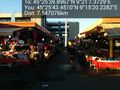
Waiting for #93 bus @45.4654,9.2277
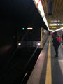
Taking to the underground @45.4405,9.2241
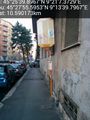
Next bus 412 at 8:05, so time for shopping @45.4287,9.2556
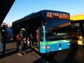
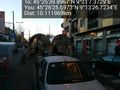
Bus to Vigliano @45.4295,9.2564
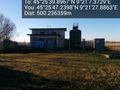
Unusual structure @45.4298,9.3577
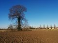
More or less west @45.4278,9.3520
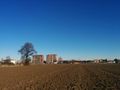
Northwestish @45.4278,9.3521


