Difference between revisions of "2015-03-08 48 8"
imported>Elimik31 ([live picture] [http://www.openstreetmap.org/?lat=48.92234167&lon=8.29734333&zoom=16&layers=B000FTF @48.9223,8.2973]) |
imported>FippeBot m (Location) |
||
| (11 intermediate revisions by 5 users not shown) | |||
| Line 18: | Line 18: | ||
__NOTOC__ | __NOTOC__ | ||
== Location == | == Location == | ||
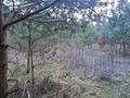
| − | + | The geohash was next to a gravel pit in Durmersheim, between some trees on the edge of a forest. There were bycicle tracks nearby and some desire paths leading to the exact location of the geohash. | |
| + | |||
== Participants == | == Participants == | ||
| − | + | [[User:Elimik31|Elimik31]] ([[User talk:Elimik31|talk]]) | |
| − | + | ||
| + | [[User:Ator|Ator]] ?? | ||
== Plans == | == Plans == | ||
| Line 28: | Line 30: | ||
== Expedition == | == Expedition == | ||
| − | + | Today was really nice weather, probably the warmest day this year and the geohash location was only 13 km from me, so I spontaneously decided to do a small bycicle tour and get to this lazy geohash, which is actually my second geohash ever. On the way there I drove past a place where sailplanes were launching and landing, that was nice. At the geohash location I left my bike at the nearest dirt track and went into the trees. My cheap smartphone has some weird GPS and it was a bit glitchy, so it took me some time to find the "exact" location. It seem that at some point, the geohasher Ator found my bike, but somehow we didn't meet each other. Is it possible that Ator didn't went off the dirt track as I did? --[[User:Elimik31|Elimik31]] ([[User talk:Elimik31|talk]]) 17:50, 8 March 2015 (EDT) | |
== Tracklog == | == Tracklog == | ||
| Line 42: | Line 44: | ||
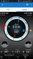
Image:2015-03-08_48_8_elimik31_1425832818109.jpg | [http://www.openstreetmap.org/?lat=48.92234167&lon=8.29734333&zoom=16&layers=B000FTF @48.9223,8.2973] | Image:2015-03-08_48_8_elimik31_1425832818109.jpg | [http://www.openstreetmap.org/?lat=48.92234167&lon=8.29734333&zoom=16&layers=B000FTF @48.9223,8.2973] | ||
| + | |||
| + | Image:2015-03-08_48_8_elimik31_1425833422978.jpg | [http://www.openstreetmap.org/?lat=48.92216000&lon=8.29612500&zoom=16&layers=B000FTF @48.9222,8.2961] "Kiesgrube" | ||
| + | |||
| + | Image:2015-03-08_48_8_Ator_1425834707000.jpg | It was a nice way on a nice Sunday. | ||
| + | |||
| + | Image:2015-03-08_48_8_Ator_1425834770131.jpg | | ||
| + | |||
| + | Image:2015-03-08_48_8_Ator_1425834802118.jpg | Wow, how did we mange to miss each other? Is there an achievment for that? ~Elimik | ||
</gallery> | </gallery> | ||
| Line 49: | Line 59: | ||
| − | |||
| − | |||
| − | |||
| − | |||
| − | |||
| − | |||
| − | |||
| − | |||
| − | |||
| − | |||
| − | |||
[[Category:Expeditions]] | [[Category:Expeditions]] | ||
| − | |||
[[Category:Expeditions with photos]] | [[Category:Expeditions with photos]] | ||
| − | |||
| − | |||
| − | |||
| − | |||
| − | |||
[[Category:Coordinates reached]] | [[Category:Coordinates reached]] | ||
| − | + | {{location|DE|BW|RA}} | |
| − | |||
| − | |||
| − | |||
| − | |||
| − | |||
| − | |||
| − | |||
| − | |||
| − | |||
| − | |||
| − | |||
| − | |||
| − | |||
| − | |||
| − | |||
| − | |||
| − | |||
Latest revision as of 02:58, 15 August 2019
| Sun 8 Mar 2015 in 48,8: 48.9223329, 8.2975105 geohashing.info google osm bing/os kml crox |
Location
The geohash was next to a gravel pit in Durmersheim, between some trees on the edge of a forest. There were bycicle tracks nearby and some desire paths leading to the exact location of the geohash.
Participants
Ator ??
Plans
Expedition
Today was really nice weather, probably the warmest day this year and the geohash location was only 13 km from me, so I spontaneously decided to do a small bycicle tour and get to this lazy geohash, which is actually my second geohash ever. On the way there I drove past a place where sailplanes were launching and landing, that was nice. At the geohash location I left my bike at the nearest dirt track and went into the trees. My cheap smartphone has some weird GPS and it was a bit glitchy, so it took me some time to find the "exact" location. It seem that at some point, the geohasher Ator found my bike, but somehow we didn't meet each other. Is it possible that Ator didn't went off the dirt track as I did? --Elimik31 (talk) 17:50, 8 March 2015 (EDT)
Tracklog
Photos

GPS is crappy... But I arrived at the Geohash. More info later. @48.9223,8.2974
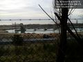
@48.9222,8.2961 "Kiesgrube"
It was a nice way on a nice Sunday.
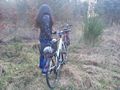
Wow, how did we mange to miss each other? Is there an achievment for that? ~Elimik


