Difference between revisions of "2015-03-14 49 8"
From Geohashing
imported>Q-Owl m (→Achievements / Honorable Mention) |
imported>Q-Owl |
||
| Line 16: | Line 16: | ||
== Plan == | == Plan == | ||
| − | Drive by car to the hash area after work and walk to the hashpoint. | + | Drive by car to the hash area after work and walk to the hashpoint. Find some geocaches. |
== Expedition == | == Expedition == | ||
| − | + | We drove to [[wikipedia:Ober-Ramstadt|Ober-Ramstadt]] in the northern part of the Odenwald and then to the little village Hahn. From here we walked into the wood and half a mile up a hill. The hashpoint was easy to find (about 16:40 h), I took some photos and we walked back to the car. After that we visited an eartcache and a geocache. | |
| − | |||
| − | |||
| − | |||
| − | |||
| − | |||
| − | |||
== Photos == | == Photos == | ||
<!-- Insert pictures between the gallery tags using the following format: | <!-- Insert pictures between the gallery tags using the following format: | ||
| Line 34: | Line 28: | ||
<gallery perrow="5" > | <gallery perrow="5" > | ||
| − | Image:2015-03-14 49 8 walk.jpg | Walk to the hashpoint and view | + | Image:2015-03-14 49 8 walk.jpg | Walk to the hashpoint and view NE |
Image:2015-03-14 49 8 proof.png | Proof | Image:2015-03-14 49 8 proof.png | Proof | ||
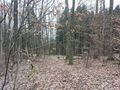
Image:2015-03-14 49 8 view.jpg | The hp lies there in the west | Image:2015-03-14 49 8 view.jpg | The hp lies there in the west | ||
Revision as of 21:57, 14 March 2015

| Sat 14 Mar 2015 in 49,8: 49.8088568, 8.7734155 geohashing.info google osm bing/os kml crox |
Location
Near Wembach-Hahn in the northwestern part of the Odenwald.
Participants
Plan
Drive by car to the hash area after work and walk to the hashpoint. Find some geocaches.
Expedition
We drove to Ober-Ramstadt in the northern part of the Odenwald and then to the little village Hahn. From here we walked into the wood and half a mile up a hill. The hashpoint was easy to find (about 16:40 h), I took some photos and we walked back to the car. After that we visited an eartcache and a geocache.
Photos
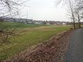
Walk to the hashpoint and view NE
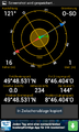
Proof
- 2015-03-14 49 8 view.jpg
The hp lies there in the west
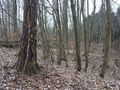
At the hp: View north
View west

Grin²


Achievements / Honorable Mention
Q-Owl earned the Land geohash achievement
|
Q-Owl & Q-Owla earned the Consecutive geohash achievement
|
Q-Owl & Q-Owla earned the Pi Day Achievement
|