Difference between revisions of "2015-03-22 50 20"
imported>Malgond (Created page with "{{subst:Expedition|lat=50|lon=20|date=2015-03-22}}") |
imported>FippeBot m (Location) |
||
| (29 intermediate revisions by one other user not shown) | |||
| Line 1: | Line 1: | ||
| − | |||
| − | |||
| − | |||
| − | |||
| − | |||
| − | |||
| − | |||
| − | |||
| − | |||
| − | |||
{{meetup graticule | {{meetup graticule | ||
| lat=50 | | lat=50 | ||
| Line 15: | Line 5: | ||
}} | }} | ||
| − | |||
| − | |||
== Location == | == Location == | ||
| − | + | ||
| + | Just off Igołomska street in Cracow, in a patch of willow trees. | ||
== Participants == | == Participants == | ||
| − | + | ||
| − | + | [[User:Malgond|Malgond]] with kids. | |
== Plans == | == Plans == | ||
| − | < | + | |
| + | [[User:Malgond|Malgond]] plans go there <del>by tram</del> <ins>by car</ins>, to arrive at meet-up time. | ||
| + | |||
| + | [[File:2015-03-22_50_20_plans_view.png]] | ||
== Expedition == | == Expedition == | ||
| − | |||
| − | == | + | We have encountered some unforeseen time constraints, so we had to forgo going there by public transport and we were able to set out only at 3:26 local time. Therefore even if I drove semi-aggresively, we have arrived a bit late, at six past four. We (rightly!) did not expect to meet anyone, but just in case... |
| − | <!-- if | + | |
| + | ==== Communist legacy ==== | ||
| + | |||
| + | Our route led us through [[wikipedia:Nowa Huta|Nowa Huta]], a new city (now being a district of Cracow) constructed in early 1950s during [[wikipedia:Peoples' Republic of Poland|Communist rule]] in Poland, around huge [[wikipedia:Tadeusz Sendzimir Steelworks|steel works]] named after [[wikipedia:Vladimir Lenin|Vladimir Lenin]]. In fact, the Igołomska street near wich the hash point was located runs along the southern fence of the industrial complex. | ||
| + | |||
| + | We got into the car and drove off. My daughter was making some photos along the way - thanks to her I have some more to write about. All photos from the car trip are by her, the photos from the hashpoint by me - except one. Soon we drove past the southernmost tram line terminus in Cracow, from which we originally intended to take tram number 10 to reach a tram stop in the Igołomska street just shy of the easternmost terminus in Pleszów - unfortunately we could not afford the time required to complete such a journey this Sunday. We crossed the Vistula river on a bridge in Nowohucka street and soon reached somewhat convoluted net of streets and roundabouts of Nowa Huta and the neighbouring residential districts. I rarely visit those parts and sometimes get lost there even if no road works. Fortunately, this time I have managed to stick to the planned route without undue detours - on the way there, at least. After not so much time we arrived at the central square of Nowa Huta, with its characteristic and unique socrealistic architecture. Previously it was devoted to [[wikipedia:Joseph Stalin|Joseph Stalin]], currently it is named after U.S. President [[wikipedia:Ronald Reagan|Ronald Reagan]]. | ||
| + | |||
| + | <gallery perrow="5"> | ||
| + | Image:2015-03-22 50 20-1.jpeg | Crossing the Vistula river. The Cracow CHP plant in the background. | ||
| + | Image:2015-03-22 50 20-2.jpeg | Road works in Aleja Pokoju. | ||
| + | Image:2015-03-22 50 20-3.jpeg | Speeding along the tram line we failed to ride today. | ||
| + | Image:2015-03-22 50 20-4.jpeg | Ronald Reagan Central Square in Nowa Huta. | ||
| + | Image:2015-03-22 50 20-5.jpeg | Reagan square. Still some road works. | ||
| + | </gallery> | ||
| + | |||
| + | After driving past Central Square we passed by a building in which a museum of the [[wikipedia:Peoples' Republic of Poland|PRL]] is going to be open some day. The building had been erected exactly in that time, and its facade is a bit tarnished today - I just thought it should be left like it is now to better depict the sorry state of the communist Poland. | ||
| + | |||
| + | A few minutes later we arrived at the intersection which lies not far from the [[wikipedia:Wanda Mound|Mound of Wanda]], named after a legendary daughter of a legendary founder of our city. We turned right and drove along the Igołomska street and the perimeter fence of the steel works. The tram line goes between the street and the fence, with the stops dully named ''Gate no. 4.'', ''Gate no. 5'', ''Coke works'' etc. - after the numbers of the entry gates to the steel works complex and the function of one of the subdivisions. One stop name, however, tells a story. The second-to-last tram stop on the line is mysteriously called '''''Meksyk''''' (''Mexico''). Indeed the whole neighborhood is called so. How come? | ||
| + | |||
| + | First of all, I need to explain the likely origin and popular meaning of the name. The primary meaning of the word ''Meksyk'' in the Polish language is ''Mexico'', i.e. the name of the country in Central America and its capital. In colloquial or slang usage, however, it serves as a metaphor of an unruly, out-of-control place or situation. The metaphor, most likely influenced by Western movies, refers to the stereotype of a faraway, wild country, where violence prevails and the rule of law do not reach. Even today one could hear ''Ale Meksyk!'' (''What a Mexico!'') in reference to a nasty brawl, riot, or just a really bad neighborhood. | ||
| + | |||
| + | The place we're talking about has been named ''Meksyk'' in the early years of construction of the giant steel works complex [http://ciekawykrakow.blogspot.com/2013/01/nowohucki-meksyk.html], when a part of a former rural village of Pleszów become a work settlement for four thousands of construction workers, comprised of 38 wooden and 4 brick barracks. The original settlers were members of the so-called work brigades of a compulsory paramilitary youth organisation existing in the early years of communist Poland called (my imperfect translation) [[wikipedia:pl:Powszechna Organizacja „Służba Polsce”|''Universal Organisation „Service for Poland”'']] [http://historia.org.pl/2011/02/07/sluzba-polsce-zapomniana-organizacja/], modeled along the lines of the [[wikipedia:Soviet Union|Soviet Russia's]] [[wikipedia:Komsomol|Komsomol]]. The yunacks (as the members were called) lived and worked there for no more than six months at a time, and were rather poorly supervised - the supervisors within the organization were mostly demobilized, demoted or otherwise ''unwanted'' (mostly for political reasons) officers of the military; their poor morale did not influence the young people positively, to say the least. Moreover, the barracks were heavily overcrowded. The loosely coupled, poorly supervised and compulsory community developed all sorts of problems: heavy drinking, thievery, robbery, beatings etc. Bad reputation of Meksyk soon reached Cracow and urban legends sprawled: that inhabitants layed down to sleep in their clothes or they would be robbed of them otherwise; that [[wikipedia:Milicja Obywatelska|militiamen]] and other figures of authority rarely if ever ventured there out of fear; and even a purported statement of an anonymous militiaman that ''the only way to calm down the company was shooting several rounds from [[wikipedia:PPSh-41|pepesha]] through the roof''. | ||
| + | |||
| + | In the later years after the steel works complex have started operating, voluntary seasonal construction workers lived there (only men), mostly villagers who came there to earn relatively good wages during autumn and winter when the work on their home farms mostly stopped. The settlement was officially renamed ''Workers' Hostels Settlement of the State Enterprise for Construction of Lenin Steel Works in Nowa Huta'', but the much shorter name ''Meksyk'' apparently stuck. | ||
| + | |||
| + | Today there's no trace of the barracks and only the name remained - as the traditional name of the neighborhood, the official name of the tram stop and the name of a private-owned truckers' bar and (currently a BP franchise) gas station. Several other private enterprises are located on the former work settlement grounds as well. | ||
| − | |||
| − | |||
| − | |||
| − | |||
<gallery perrow="5"> | <gallery perrow="5"> | ||
| + | Image:2015-03-22 50 20-6.jpeg | Museum of Peoples' Republic of Poland under construction. Looks like a real thing! | ||
| + | Image:2015-03-22 50 20-7.jpeg | Approaching Igołomska street. Mound of Wanda behind the trees. | ||
| + | Image:2015-03-22 50 20-8.jpeg | Tram stop on the line to Pleszów. Steel works in the background. | ||
| + | Image:2015-03-22 50 20-9.jpeg | Half-successful attempt at capturing the "Meksyk" ("Mexico") bar. | ||
</gallery> | </gallery> | ||
| − | == | + | ==== At the hash ==== |
| − | |||
| − | |||
| + | We drove past the ''Meksyk'' bar and a few moments later we've arrived at the hash. I have parked the car in the driveway of a car repair company specializing in exhaust mufflers (Polish: tłumiki) and went to the other side of the road to take photos as the evidence of our expedtion, the first two photos in the below gallery can be compared to [http://goo.gl/maps/BBgqj this] and [http://goo.gl/maps/pUcQu this] Google Street Views, if anybody really wants to make sure we got to the right place :-) | ||
| − | + | I have also made a photo from the driveway towards the hash and the two trees that can be seen on the aerial view, than we have found the approximate location of the hash between budding willow-trees. In the last photo (by my daughter) male catkins of a willow can be seen. | |
| − | |||
| − | |||
| − | + | There were no signs of other geohashers and nobody appeared within some time so we got back to the car and drove home. The kids wanted to see the Mound of Wanda closer, so I decided to take a different route in order to drive along it as we had no time to climb it, and I got lost in the streets of Nowa Huta, as usual. Finally I encountered a somewhat familiar street and was able to reestablish my orientation and drive straight home. | |
| − | < | + | <gallery perrow="5"> |
| − | <!-- | + | Image:2015-03-22 50 20-10.jpeg | In the Igołomska street looking south. Kids have already found the hash. |
| − | + | Image:2015-03-22 50 20-11.jpeg | In the Igołomska street looking north. Huge gantries of the steel works. | |
| − | --> | + | Image:2015-03-22 50 20-12.jpeg | The Two Trees :-) |
| + | Image:2015-03-22 50 20-13.jpeg | Kids and our dog at the hash. | ||
| + | <!-- Image:2015-03-22 50 20-14.jpeg --> | ||
| + | Image:2015-03-22 50 20-15.jpeg | Geohashers in the willows... | ||
| + | </gallery> | ||
| − | + | == Achievements == | |
| + | {{#vardefine:ribbonwidth|600px}} | ||
| + | [[Category:Poland]] | ||
[[Category:Expeditions]] | [[Category:Expeditions]] | ||
| − | + | [[Category:Coordinates reached]] | |
[[Category:Expeditions with photos]] | [[Category:Expeditions with photos]] | ||
| − | |||
[[Category:Expedition without GPS]] | [[Category:Expedition without GPS]] | ||
| − | + | [[Category:Expeditions with dogs]] | |
| − | |||
| − | |||
| − | [[Category: | ||
| + | {{land geohash | ||
| + | | latitude = 50 | ||
| + | | longitude = 20 | ||
| + | | date = 2015-03-22 | ||
| + | | name = [[User:Malgond|Malgond]] | ||
| + | | image = 2015-03-22_50_20-15.jpeg | ||
| + | }} | ||
| − | - | + | {{drag-along |
| − | + | | latitude = 50 | |
| − | -- | + | | longitude = 20 |
| − | + | | date = 2015-03-22 | |
| − | [[ | + | | name = [[User:Malgond|Malgond]] |
| − | + | | partner = his kids | |
| − | + | | image = 2015-03-22_50_20-15.jpeg | |
| − | + | }} | |
| − | + | {{No_batteries_geohash | |
| − | + | | latitude = 50 | |
| − | + | | longitude = 20 | |
| − | + | | date = 2015-03-22 | |
| − | [[ | + | | name = [[User:Malgond|Malgond]] |
| − | + | | image = 2015-03-22_50_20-15.jpeg | |
| − | + | }} | |
| + | {{location|PL|K|K}} | ||
Latest revision as of 03:08, 15 August 2019
| Sun 22 Mar 2015 in 50,20: 50.0718751, 20.1057869 geohashing.info google osm bing/os kml crox |
Contents
Location
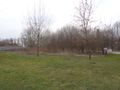
Just off Igołomska street in Cracow, in a patch of willow trees.
Participants
Malgond with kids.
Plans
Malgond plans go there by tram by car, to arrive at meet-up time.

Expedition
We have encountered some unforeseen time constraints, so we had to forgo going there by public transport and we were able to set out only at 3:26 local time. Therefore even if I drove semi-aggresively, we have arrived a bit late, at six past four. We (rightly!) did not expect to meet anyone, but just in case...
Communist legacy
Our route led us through Nowa Huta, a new city (now being a district of Cracow) constructed in early 1950s during Communist rule in Poland, around huge steel works named after Vladimir Lenin. In fact, the Igołomska street near wich the hash point was located runs along the southern fence of the industrial complex.
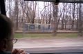
We got into the car and drove off. My daughter was making some photos along the way - thanks to her I have some more to write about. All photos from the car trip are by her, the photos from the hashpoint by me - except one. Soon we drove past the southernmost tram line terminus in Cracow, from which we originally intended to take tram number 10 to reach a tram stop in the Igołomska street just shy of the easternmost terminus in Pleszów - unfortunately we could not afford the time required to complete such a journey this Sunday. We crossed the Vistula river on a bridge in Nowohucka street and soon reached somewhat convoluted net of streets and roundabouts of Nowa Huta and the neighbouring residential districts. I rarely visit those parts and sometimes get lost there even if no road works. Fortunately, this time I have managed to stick to the planned route without undue detours - on the way there, at least. After not so much time we arrived at the central square of Nowa Huta, with its characteristic and unique socrealistic architecture. Previously it was devoted to Joseph Stalin, currently it is named after U.S. President Ronald Reagan.
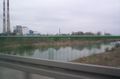
Crossing the Vistula river. The Cracow CHP plant in the background.
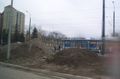
Road works in Aleja Pokoju.
Speeding along the tram line we failed to ride today.
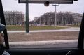
Ronald Reagan Central Square in Nowa Huta.
Reagan square. Still some road works.


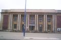
After driving past Central Square we passed by a building in which a museum of the PRL is going to be open some day. The building had been erected exactly in that time, and its facade is a bit tarnished today - I just thought it should be left like it is now to better depict the sorry state of the communist Poland.
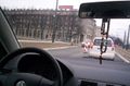
A few minutes later we arrived at the intersection which lies not far from the Mound of Wanda, named after a legendary daughter of a legendary founder of our city. We turned right and drove along the Igołomska street and the perimeter fence of the steel works. The tram line goes between the street and the fence, with the stops dully named Gate no. 4., Gate no. 5, Coke works etc. - after the numbers of the entry gates to the steel works complex and the function of one of the subdivisions. One stop name, however, tells a story. The second-to-last tram stop on the line is mysteriously called Meksyk (Mexico). Indeed the whole neighborhood is called so. How come?
First of all, I need to explain the likely origin and popular meaning of the name. The primary meaning of the word Meksyk in the Polish language is Mexico, i.e. the name of the country in Central America and its capital. In colloquial or slang usage, however, it serves as a metaphor of an unruly, out-of-control place or situation. The metaphor, most likely influenced by Western movies, refers to the stereotype of a faraway, wild country, where violence prevails and the rule of law do not reach. Even today one could hear Ale Meksyk! (What a Mexico!) in reference to a nasty brawl, riot, or just a really bad neighborhood.
The place we're talking about has been named Meksyk in the early years of construction of the giant steel works complex [1], when a part of a former rural village of Pleszów become a work settlement for four thousands of construction workers, comprised of 38 wooden and 4 brick barracks. The original settlers were members of the so-called work brigades of a compulsory paramilitary youth organisation existing in the early years of communist Poland called (my imperfect translation) Universal Organisation „Service for Poland” [2], modeled along the lines of the Soviet Russia's Komsomol. The yunacks (as the members were called) lived and worked there for no more than six months at a time, and were rather poorly supervised - the supervisors within the organization were mostly demobilized, demoted or otherwise unwanted (mostly for political reasons) officers of the military; their poor morale did not influence the young people positively, to say the least. Moreover, the barracks were heavily overcrowded. The loosely coupled, poorly supervised and compulsory community developed all sorts of problems: heavy drinking, thievery, robbery, beatings etc. Bad reputation of Meksyk soon reached Cracow and urban legends sprawled: that inhabitants layed down to sleep in their clothes or they would be robbed of them otherwise; that militiamen and other figures of authority rarely if ever ventured there out of fear; and even a purported statement of an anonymous militiaman that the only way to calm down the company was shooting several rounds from pepesha through the roof.
In the later years after the steel works complex have started operating, voluntary seasonal construction workers lived there (only men), mostly villagers who came there to earn relatively good wages during autumn and winter when the work on their home farms mostly stopped. The settlement was officially renamed Workers' Hostels Settlement of the State Enterprise for Construction of Lenin Steel Works in Nowa Huta, but the much shorter name Meksyk apparently stuck.
Today there's no trace of the barracks and only the name remained - as the traditional name of the neighborhood, the official name of the tram stop and the name of a private-owned truckers' bar and (currently a BP franchise) gas station. Several other private enterprises are located on the former work settlement grounds as well.
Museum of Peoples' Republic of Poland under construction. Looks like a real thing!
Approaching Igołomska street. Mound of Wanda behind the trees.
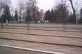
Tram stop on the line to Pleszów. Steel works in the background.
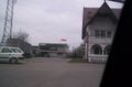
Half-successful attempt at capturing the "Meksyk" ("Mexico") bar.


At the hash
We drove past the Meksyk bar and a few moments later we've arrived at the hash. I have parked the car in the driveway of a car repair company specializing in exhaust mufflers (Polish: tłumiki) and went to the other side of the road to take photos as the evidence of our expedtion, the first two photos in the below gallery can be compared to this and this Google Street Views, if anybody really wants to make sure we got to the right place :-)
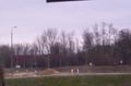
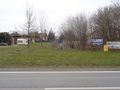
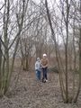
I have also made a photo from the driveway towards the hash and the two trees that can be seen on the aerial view, than we have found the approximate location of the hash between budding willow-trees. In the last photo (by my daughter) male catkins of a willow can be seen.
There were no signs of other geohashers and nobody appeared within some time so we got back to the car and drove home. The kids wanted to see the Mound of Wanda closer, so I decided to take a different route in order to drive along it as we had no time to climb it, and I got lost in the streets of Nowa Huta, as usual. Finally I encountered a somewhat familiar street and was able to reestablish my orientation and drive straight home.
In the Igołomska street looking south. Kids have already found the hash.
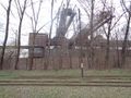
In the Igołomska street looking north. Huge gantries of the steel works.
The Two Trees :-)
Kids and our dog at the hash.

Geohashers in the willows...


Achievements
Malgond earned the Land geohash achievement
|
Malgond earned the Drag-along achievement
|
Malgond earned the No Batteries Geohash Achievement
|