Difference between revisions of "2015-03-24 49 8"
From Geohashing
imported>Tads |
imported>FippeBot m (Location) |
||
| (4 intermediate revisions by one other user not shown) | |||
| Line 41: | Line 41: | ||
--> | --> | ||
<gallery perrow="5"> | <gallery perrow="5"> | ||
| + | Image:Tads_proof_2015-03-24.png | proof | ||
| + | Image:Tads_marker_2015-03-24.jpg | fragile wooden marker | ||
| + | Image:Tads_2015-03-24_49_8-1.jpg | surrounding 1 | ||
| + | Image:Tads_2015-03-24_49_8-2.jpg | surrounding 2 | ||
</gallery> | </gallery> | ||
| − | |||
| − | |||
== Achievements == | == Achievements == | ||
{{#vardefine:ribbonwidth|800px}} | {{#vardefine:ribbonwidth|800px}} | ||
| − | + | {{Bicycle geohash | latitude = 49 | longitude = 8 | date = 2015-03-24 | name = [[User:tads|tads]] }} | |
| − | |||
| − | |||
| − | |||
| − | |||
| − | |||
| − | |||
| − | |||
| − | |||
| − | [[ | ||
| − | |||
| − | |||
[[Category:Expeditions]] | [[Category:Expeditions]] | ||
| − | |||
[[Category:Expeditions with photos]] | [[Category:Expeditions with photos]] | ||
| − | |||
| − | |||
| − | |||
| − | |||
| − | |||
| − | |||
[[Category:Coordinates reached]] | [[Category:Coordinates reached]] | ||
| − | + | {{location|DE|HE|DA}} | |
| − | |||
| − | |||
| − | |||
| − | |||
| − | |||
| − | |||
| − | |||
| − | |||
| − | |||
| − | |||
| − | |||
| − | |||
| − | |||
| − | |||
| − | |||
| − | |||
| − | |||
Latest revision as of 03:09, 15 August 2019
| Tue 24 Mar 2015 in 49,8: 49.8835257, 8.5783652 geohashing.info google osm bing/os kml crox |
Location
The hashpoint is located at (49.88352569, 8.57836523) in a wood between Griesheim and Weiterstadt close to Darmstadt.
Participants
Plans
tads plans to visit the HP by bike right after lunch. Hoping for some sunny moments.
Expedition
tads had a nice bike tour to the hash point. Walked into the forest for the last steps and had a snack at the coordinates.
Photos
proof
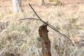
fragile wooden marker
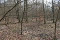
surrounding 1
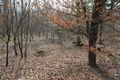
surrounding 2


Achievements
tads earned the Bicycle geohash achievement
|