Difference between revisions of "2015-03-30 49 7"
imported>DLichti (Location added) |
imported>FippeBot m (Location) |
||
| (6 intermediate revisions by one other user not shown) | |||
| Line 1: | Line 1: | ||
| − | + | [[Image:{{{image|2015-03-30_49_7_Rock.jpg}}}|thumb|left]] | |
| − | |||
| − | |||
| − | [[Image:{{{image| | ||
| − | |||
| − | |||
| − | |||
| − | |||
| − | |||
| − | |||
{{meetup graticule | {{meetup graticule | ||
| lat=49 | | lat=49 | ||
| Line 15: | Line 6: | ||
}} | }} | ||
| − | |||
__NOTOC__ | __NOTOC__ | ||
== Location == | == Location == | ||
| Line 28: | Line 18: | ||
== Expedition == | == Expedition == | ||
| − | + | We parked the car in Birkenhördt at 15:50. From there, the map suggested a 1km walk to the HP. But because this seemed to be an unnecessary detour, we decided to go straight through the forest. Interestingly, there already was a path which didn't show up on the map, so we followed it. This resulted in an only 450m walk to the HP which we found at around 16:00. The GPS was not very reliable, and when we followed it 10m in one direction, it told us, that the point was now 10m in the opposite direction. But since we danced around the place for some time, I think we very probably reached it at some point. | |
| − | + | Since we didn't want to go home after only a few meters, we decided to go on to explore the rest of the hill. It was nice, but otherwise rather unspectacular. We reached the top of the hill, but couldn't see very far from there. On our way back down, we came by a rock which we climbed. There, the view was slightly better. After some more detours, we returned to the car at around 17:10 a drove home. | |
| − | |||
== Photos == | == Photos == | ||
| Line 38: | Line 27: | ||
--> | --> | ||
<gallery perrow="5"> | <gallery perrow="5"> | ||
| + | Image:2015-03-30 49 7 Surroundings.jpg | According to map and GPS, the HP is probably visible somewhere on this photo. | ||
| + | Image:2015-03-30 49 7 Hashpoint.jpg | After some dancing around, we decided to declare this tree the hash point and our goal reached. | ||
| + | Image:2015-03-30 49 7 Proof.png | I finally got a small distance (labeled Avst. (m)) displayed on my GPS. | ||
| + | Image:2015-03-30 49 7 Summit.jpg | The top of the hill marked by a stone. | ||
| + | Image:2015-03-30 49 7 Rock.jpg | A rock. | ||
</gallery> | </gallery> | ||
== Achievements == | == Achievements == | ||
{{#vardefine:ribbonwidth|800px}} | {{#vardefine:ribbonwidth|800px}} | ||
| − | |||
| + | {{Minesweeper geohash | ||
| − | + | | graticule = Mannheim, Germany | |
| − | + | | ranknumber = 1 | |
| − | + | | w = true | |
| + | | name = DLichti | ||
| − | + | }} | |
| + | |||
| + | {{OpenStreetMap achievement | ||
| + | |||
| + | | latitude = 49 | ||
| + | | longitude = 7 | ||
| + | | date = 2015-03-30 | ||
| + | | OSMlink = 29870531 | ||
| + | | name = DLichti | ||
| − | + | }} | |
| − | |||
| − | |||
| − | |||
| − | |||
[[Category:Expeditions]] | [[Category:Expeditions]] | ||
| − | + | [[Category:Coordinates reached]] | |
[[Category:Expeditions with photos]] | [[Category:Expeditions with photos]] | ||
| − | + | {{location|DE|RP|SÜW}} | |
| − | |||
| − | |||
| − | |||
| − | |||
| − | |||
| − | |||
| − | |||
| − | |||
| − | |||
| − | |||
| − | |||
| − | |||
| − | |||
| − | |||
| − | |||
| − | |||
| − | |||
| − | |||
| − | |||
| − | |||
| − | |||
| − | |||
| − | |||
Latest revision as of 03:11, 15 August 2019

| Mon 30 Mar 2015 in 49,7: 49.1196432, 7.9262909 geohashing.info google osm bing/os kml crox |
Location
In the woods near Birkenhördt.
Participants
- DLichti
- A friend
Plans
Take the car to Birkenhördt. Try to be at the HP at around 16:00.
Expedition
We parked the car in Birkenhördt at 15:50. From there, the map suggested a 1km walk to the HP. But because this seemed to be an unnecessary detour, we decided to go straight through the forest. Interestingly, there already was a path which didn't show up on the map, so we followed it. This resulted in an only 450m walk to the HP which we found at around 16:00. The GPS was not very reliable, and when we followed it 10m in one direction, it told us, that the point was now 10m in the opposite direction. But since we danced around the place for some time, I think we very probably reached it at some point.
Since we didn't want to go home after only a few meters, we decided to go on to explore the rest of the hill. It was nice, but otherwise rather unspectacular. We reached the top of the hill, but couldn't see very far from there. On our way back down, we came by a rock which we climbed. There, the view was slightly better. After some more detours, we returned to the car at around 17:10 a drove home.
Photos
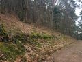
According to map and GPS, the HP is probably visible somewhere on this photo.
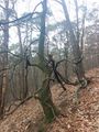
After some dancing around, we decided to declare this tree the hash point and our goal reached.
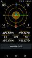
I finally got a small distance (labeled Avst. (m)) displayed on my GPS.
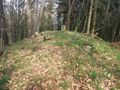
The top of the hill marked by a stone.
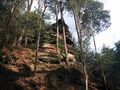
A rock.


Achievements
DLichti achieved level 1 of the Minesweeper Geohash achievement
|
DLichti earned the OpenStreetMap achievement
|