Difference between revisions of "2015-04-04 48 9"
imported>DODO (Created page with "{{Subst:Expedition |lat=48 |lon=9 |date=2015-04-04 }}") |
imported>FippeBot m (Location) |
||
| (12 intermediate revisions by one other user not shown) | |||
| Line 19: | Line 19: | ||
== Location == | == Location == | ||
<!-- where you've surveyed the hash to be --> | <!-- where you've surveyed the hash to be --> | ||
| + | In a forest next to a mainroad and an exqusit hotel in Stuttgart Degerloch. | ||
== Participants == | == Participants == | ||
<!-- who attended: If you link to your wiki user name in this section, your expedition will be picked up by the various statistics generated for geohashing. You may use three tildes ~ as a shortcut to automatically insert the user signature of the account you are editing with. | <!-- who attended: If you link to your wiki user name in this section, your expedition will be picked up by the various statistics generated for geohashing. You may use three tildes ~ as a shortcut to automatically insert the user signature of the account you are editing with. | ||
--> | --> | ||
| + | [[User:DODO|DODO]] | ||
== Plans == | == Plans == | ||
<!-- what were the original plans --> | <!-- what were the original plans --> | ||
| + | To go there by bike and stay the night at the hotel. | ||
== Expedition == | == Expedition == | ||
<!-- how it all turned out. your narrative goes here. --> | <!-- how it all turned out. your narrative goes here. --> | ||
| + | Number one in this years bicycle hash tour (to number [[2015-04-05_49_9|two]]). | ||
| + | |||
| + | I had some days of,and as the girls were away for playing music this week, I wanted to go hash-biking. So the moment the hash came up on thursday, I started planing the different options. The nearest hashpoint was 49_8 near Alzey, and I could go to Wiesbaden from there and then to Aschaffenburg. But that would have meant, that I had to cross the city of Frankfurt on the third day,what sounded boring. | ||
| + | |||
| + | The next opportunity would be to start with 48_8 south of Baden-Baden. I had to go to Sankt Georgen in the Black Forest the next day and then continue to Freiburg. But it was probable that the next hash would be in the black forest again and I didn't want to just drive up and down the black forest again and again in my holiday. Nevertheless this seemed to be the most reasonable decision. | ||
| + | |||
| + | Well, just for fun, let's have a look at 49_9. Near Miltenberg, 130 KM by bike. No, that's to far. And 48_9? It's even farer as the crow flies, but it is "only" 110 KM by bike. And look, there is a hotel direct next to the hash. Come on, you did longer tours when you were younger - yeah, but I was younger then... Well, maybe there is no good continuation and I can still go to Baden-Baden? No, there are even two possibilities to continue: to the south east via Sigmaringen and Memmingen, or to the north east via Heilbronn and Ellwangen. And so the target for today was set on friday evening. | ||
| + | |||
| + | On the next morning it was raining, but the girls teased me, that a little rain won't stop me from my big plans.Well, Ok, but first I'll do the dishes. And buy beverages and... well, I have to start now, I have a long way to go. And the rain continued. Well, what should I tell about the ride? I saw several castles on the way but it was to wet, to take the camera out for them. I saw an ostrich, and it was exotic enough to pick the camera even if it rains and a celtic barrow what was surprising enough to do so again. I had a flat tire in Bretten and resigned a break in the very nice town of Vaihingen an der Enz as I didn't want to sit around in my wet clothes. | ||
| + | |||
| + | At 5 o'clock I reached the northern outskirts of Stuttgart. I crossed the industrial surroundings and then the inner city and an hour later I reached the Gablenberger Hauptstraße respectively the Gablenberger Weg. I was on my bike nearly nonstop for seven hours now and did more than 100 kilometers. I was tired and wet and now the final step-up begins. As I found out on the next morning it was a distance of less than 1 KM but it gains more than 200 m of heigth. Of course Ipushed my bike, but even this was hardly possible. My legs hurt with every step (and even when I paused, what happened every 100m (at the beginning, soon it was every 25 m). And then a young couple with a dog came from a byroad and the man asked if he should push my bike. I must have looked really pitiful. Unfortunately they had to deflect 200 m before the top, and so I had to do the rest on my own again (although the man offered to do the rest for me to, but I couldn't accept that, as he definitely was much more interested in the girl than in me). So I did the rest on my own with four or five more brakes. All in all it took me an hour to climb that last mountain and I don't know if I would had made it by my own. | ||
| + | |||
| + | From there it was just 3 more kilometers to the hashpoint in a forest next to a busy road. I just jumped in, took some pictures, left a mark and ... well, 200 m back the road then turn left and 300 m further there was a very nice hotel. So I celebrated my painful success with a soft bed, a sauna, and a delicious meal. | ||
== Tracklog == | == Tracklog == | ||
<!-- if your GPS device keeps a log, you may post a link here --> | <!-- if your GPS device keeps a log, you may post a link here --> | ||
| + | [https://www.komoot.de/tour/4493091 113 KM by bike] and please stop me from doing this again. | ||
== Photos == | == Photos == | ||
| Line 38: | Line 55: | ||
--> | --> | ||
<gallery perrow="5"> | <gallery perrow="5"> | ||
| + | Image: 2015-04-04_48_9-1.jpg|even ostriches get wet | ||
| + | Image: 2015-04-04_48_9-2.jpg|and Dodos do so either | ||
| + | Image: 2015-04-04_48_9-3.jpg|and even celtic rulers | ||
| + | Image: 2015-04-04_48_9-4.jpg|after 116 KM (the gps device voted for 112 KM) I reached the final destination | ||
| + | Image: 2015-04-04_48_9-5.jpg|the first picture of my bike (you'll see some more the next days) | ||
| + | Image: 2015-04-04_48_9-6.jpg|proof | ||
| + | Image: 2015-04-04_48_9-7.jpg|view to the west | ||
| + | Image: 2015-04-04_48_9-8.jpg|and to the east (you can see my bike next to the street) | ||
| + | Image: 2015-04-04_48_9-9.jpg|no better grin possible anymore | ||
| + | Image: 2015-04-04_48_9-10.jpg|but I still could leave a mark | ||
</gallery> | </gallery> | ||
== Achievements == | == Achievements == | ||
{{#vardefine:ribbonwidth|800px}} | {{#vardefine:ribbonwidth|800px}} | ||
| − | <!-- Add any achievement ribbons you earned below, or remove | + | <!-- Add any achievement ribbons you earned below, or remove --> |
| + | The pickings: my longest bicycle hash so far (it won't last long), a further step in the minesweeper and a totally new ribbon in my collection. And land. Yeah! | ||
| + | {{land geohash | ||
| + | | latitude = 48 | ||
| + | | longitude =9 | ||
| + | | date = 2015-04-04 | ||
| + | | name = DODO | ||
| + | }} | ||
| − | + | {{bicycle geohash | |
| − | + | | latitude = 48 | |
| − | + | | longitude = 9 | |
| + | | date = 2015-04-04 | ||
| + | | name = DODO | ||
| + | | distance = 113 KM | ||
| + | }} | ||
| − | + | {{Minesweeper geohash | |
| + | | graticule = Mannheim, Germany | ||
| + | | ranknumber = 6 | ||
| + | | nw = true | ||
| + | | n = true | ||
| + | | sw = true | ||
| + | | s = true | ||
| + | | e=true | ||
| + | | se=true | ||
| + | | name = DODO | ||
| + | }} | ||
| − | + | {{Drowned rat geohash | |
| − | + | | latitude = 48 | |
| − | + | | longitude = 9 | |
| − | + | | date = 2015-04-04 | |
| + | | name = DODO | ||
| + | | reason = cycling through rain for more than 8 hours | ||
| + | }} | ||
| − | |||
[[Category:Expeditions]] | [[Category:Expeditions]] | ||
| − | |||
[[Category:Expeditions with photos]] | [[Category:Expeditions with photos]] | ||
| − | |||
| − | |||
| − | |||
| − | |||
| − | |||
[[Category:Coordinates reached]] | [[Category:Coordinates reached]] | ||
| − | + | {{location|DE|BW|S}} | |
| − | |||
| − | |||
| − | |||
| − | |||
| − | |||
| − | |||
| − | |||
| − | |||
| − | |||
| − | |||
| − | |||
| − | |||
| − | |||
| − | |||
| − | |||
| − | |||
| − | |||
Latest revision as of 00:53, 7 August 2019
| Sat 4 Apr 2015 in 48,9: 48.7515844, 9.1959298 geohashing.info google osm bing/os kml crox |
Location
In a forest next to a mainroad and an exqusit hotel in Stuttgart Degerloch.
Participants
Plans
To go there by bike and stay the night at the hotel.
Expedition
Number one in this years bicycle hash tour (to number two).
I had some days of,and as the girls were away for playing music this week, I wanted to go hash-biking. So the moment the hash came up on thursday, I started planing the different options. The nearest hashpoint was 49_8 near Alzey, and I could go to Wiesbaden from there and then to Aschaffenburg. But that would have meant, that I had to cross the city of Frankfurt on the third day,what sounded boring.
The next opportunity would be to start with 48_8 south of Baden-Baden. I had to go to Sankt Georgen in the Black Forest the next day and then continue to Freiburg. But it was probable that the next hash would be in the black forest again and I didn't want to just drive up and down the black forest again and again in my holiday. Nevertheless this seemed to be the most reasonable decision.
Well, just for fun, let's have a look at 49_9. Near Miltenberg, 130 KM by bike. No, that's to far. And 48_9? It's even farer as the crow flies, but it is "only" 110 KM by bike. And look, there is a hotel direct next to the hash. Come on, you did longer tours when you were younger - yeah, but I was younger then... Well, maybe there is no good continuation and I can still go to Baden-Baden? No, there are even two possibilities to continue: to the south east via Sigmaringen and Memmingen, or to the north east via Heilbronn and Ellwangen. And so the target for today was set on friday evening.
On the next morning it was raining, but the girls teased me, that a little rain won't stop me from my big plans.Well, Ok, but first I'll do the dishes. And buy beverages and... well, I have to start now, I have a long way to go. And the rain continued. Well, what should I tell about the ride? I saw several castles on the way but it was to wet, to take the camera out for them. I saw an ostrich, and it was exotic enough to pick the camera even if it rains and a celtic barrow what was surprising enough to do so again. I had a flat tire in Bretten and resigned a break in the very nice town of Vaihingen an der Enz as I didn't want to sit around in my wet clothes.
At 5 o'clock I reached the northern outskirts of Stuttgart. I crossed the industrial surroundings and then the inner city and an hour later I reached the Gablenberger Hauptstraße respectively the Gablenberger Weg. I was on my bike nearly nonstop for seven hours now and did more than 100 kilometers. I was tired and wet and now the final step-up begins. As I found out on the next morning it was a distance of less than 1 KM but it gains more than 200 m of heigth. Of course Ipushed my bike, but even this was hardly possible. My legs hurt with every step (and even when I paused, what happened every 100m (at the beginning, soon it was every 25 m). And then a young couple with a dog came from a byroad and the man asked if he should push my bike. I must have looked really pitiful. Unfortunately they had to deflect 200 m before the top, and so I had to do the rest on my own again (although the man offered to do the rest for me to, but I couldn't accept that, as he definitely was much more interested in the girl than in me). So I did the rest on my own with four or five more brakes. All in all it took me an hour to climb that last mountain and I don't know if I would had made it by my own.
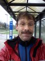
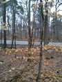
From there it was just 3 more kilometers to the hashpoint in a forest next to a busy road. I just jumped in, took some pictures, left a mark and ... well, 200 m back the road then turn left and 300 m further there was a very nice hotel. So I celebrated my painful success with a soft bed, a sauna, and a delicious meal.
Tracklog
113 KM by bike and please stop me from doing this again.
Photos
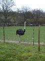
even ostriches get wet
and Dodos do so either
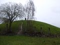
and even celtic rulers
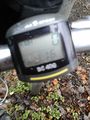
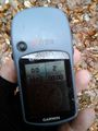
after 116 KM (the gps device voted for 112 KM) I reached the final destination
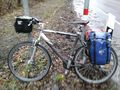
the first picture of my bike (you'll see some more the next days)
proof
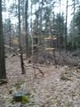
view to the west
and to the east (you can see my bike next to the street)
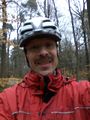
no better grin possible anymore
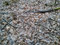
but I still could leave a mark


Achievements
The pickings: my longest bicycle hash so far (it won't last long), a further step in the minesweeper and a totally new ribbon in my collection. And land. Yeah!
DODO earned the Land geohash achievement
|
DODO earned the Bicycle geohash achievement
|
DODO achieved level 6 of the Minesweeper Geohash achievement
|
DODO earned the Drowned Rat Geohash Achievement
|