2015-04-05 48 11
From Geohashing
Revision as of 16:55, 5 April 2015 by imported>TheOneRing (Created page with "{{meetup graticule | lat=48 | lon=11 | date=2015-04-05 }} == Location == The geohash is at the edge of Alling near Fürstenfeldbruck. == Who Went == *User:TheOneRing|TheOn...")
| Sun 5 Apr 2015 in 48,11: 48.1333651, 11.2982086 geohashing.info google osm bing/os kml crox |
Contents
Location
The geohash is at the edge of Alling near Fürstenfeldbruck.
Who Went
- TheOneRing - by car.
The Expedition
TheOneRing
Happy Easter altogether. I had no other plans for today, so I took my car and drove to Alling. I found a parking spot about 140m away from the geohash and walked the rest.
The view was not very impressive and I just took the usual photographs. I walked back and drove home. I wanted to stop every now and then to take some photos of the Bayrisches Oberland, but the weather was strange: sunny, then cloudy and snowy. These weren't conditions for nice photos.
In the end I had some coffee at home. Quite a sprint trip today.
Photos
TheOneRing
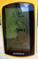
Coordinates reached
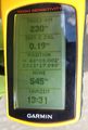
Some more information
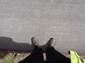
Here I am

The hasher
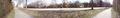
A panoramic view over the street next to the geohash


Achievements
TheOneRing earned the Land geohash achievement
|