Difference between revisions of "2015-04-07 48 11"
imported>DODO (Created page with "{{subst:Expedition |lat = 48 |lon = 11 |date = 2015-04-07 }}") |
imported>FippeBot m (Location) |
||
| (8 intermediate revisions by one other user not shown) | |||
| Line 19: | Line 19: | ||
== Location == | == Location == | ||
<!-- where you've surveyed the hash to be --> | <!-- where you've surveyed the hash to be --> | ||
| + | In the middle of a wheat field south of Neuburg an der Donau. | ||
== Participants == | == Participants == | ||
<!-- who attended: If you link to your wiki user name in this section, your expedition will be picked up by the various statistics generated for geohashing. You may use three tildes ~ as a shortcut to automatically insert the user signature of the account you are editing with. | <!-- who attended: If you link to your wiki user name in this section, your expedition will be picked up by the various statistics generated for geohashing. You may use three tildes ~ as a shortcut to automatically insert the user signature of the account you are editing with. | ||
--> | --> | ||
| + | [[User:DODO|DODO]] | ||
== Plans == | == Plans == | ||
| Line 29: | Line 31: | ||
== Expedition == | == Expedition == | ||
<!-- how it all turned out. your narrative goes here. --> | <!-- how it all turned out. your narrative goes here. --> | ||
| + | Number four in this years bicycle hash tour (to number [[2015-04-06_48_9|three]] and [[2015-04-08_48_10|five]]). | ||
| + | |||
| + | I was in the hotel in Ellwangen yesterday and were looking for todays hashpoints. So, 48_10 looks convenient. Only 30 KM away, and I am exhausted enough. But - it's in a private home. OK, maybe 48_9? It's 75 kilometers (as the crow flies). Pretty far, but possible. But it's next to a skyscraper on a parking lot (hopefully) - and it is in Stuttgart. Hey, I just came from [[2015-04-04_48_9|Stuttgart]], I don't want to go there again. But I'm tired and I promised myself, to never go more than 100 kilometers on my bike again. 49_10 is 82 kilometers, that means 130 in reality. Maybe, I can drive part of the way by train? And - just for fun - where is 48_11? | ||
| + | |||
| + | Hey, it's near Neuburg an der Donau. I've been there before and know it as a very picturesque town. It's 81 kilometers. But look, komoot says, it's only 110 kilometers by bike, and -uh, I can't believe that - just 500 m total rise. And if it get's to far, I still can take the train from Donauwörth to Neuburg. | ||
| + | |||
| + | So the promise, not to go so far again holds just 3 days. I started following the river Jagst for a while and after 10 KM I found the first landmark, the remaining of a portal to the german limes. In Lauchheim, I had to leaf the Jagst (which had its source 10 KM further anyway) and climb the first mountain. Then I came down to Bopfingen and had immediately to go upwards again. I came to a mountain called Ipf. It houses the remaining of a celtic castle. From here I crossed the Nördlinger Ried, a landscape that formed through a meteor strike and was very flat. Just in the center of the Ried lies the medieval town Nördlingen. I had a break there to buy some picnic and do some sightseeing. | ||
| + | |||
| + | Then I followed the river Wörnitz until it flows in the Donau (Danube) at Donauwörth. There are some hills ranging immediately to the banks of the Danube, so the rest of the tour was't complete flat, but it was a quite easy going and I reached Neuburg around half past four. I decided, that that's still early enough to go to the hash before I'll look for a place for the night. So I crossed Neuburg, and after 3 kliometers I reached a country lane that runs along todays hash - field. The field was planted with young wheat (I guess) and next to the field was a farm and a woman just came out of the farm with a horse. Just next to the farm was a bench and a wayside cross where I parked the bike and waited for the lady to disappear. I usually don't hurt fresh planted fields but I ride more than 100 kilometers only to walk on that field and that was exactly what I would have told anyone, who would have asked me what I was doing. But nobody asked. I reached the hashpoint next to a power pole, took the usual pictures and hurried back to my bike. Then I returned to Neuburg to find a place for my last night of this journey. | ||
== Tracklog == | == Tracklog == | ||
<!-- if your GPS device keeps a log, you may post a link here --> | <!-- if your GPS device keeps a log, you may post a link here --> | ||
| + | [https://www.komoot.de/tour/4525195 120 KM by bike] | ||
== Photos == | == Photos == | ||
| Line 38: | Line 50: | ||
--> | --> | ||
<gallery perrow="5"> | <gallery perrow="5"> | ||
| + | Image:2015-04-07_48_11-1.jpg|a gate in the limes | ||
| + | Image:2015-04-07_48_11-2.jpg|and the corresponding description | ||
| + | Image:2015-04-07_48_11-3.jpg|the church in Nördlingen | ||
| + | Image:2015-04-07_48_11-4.jpg|and a cheese shop | ||
| + | Image:2015-04-07_48_11-5.jpg|the castle in Harburg | ||
| + | Image:2015-04-07_48_11-6.jpg|my picnic place | ||
| + | Image:2015-04-07_48_11-7.jpg|view to Neuburg | ||
| + | Image:2015-04-07_48_11-8.jpg|a hash field | ||
| + | Image:2015-04-07_48_11-9.jpg|with a bicycle parking lot next to it | ||
| + | Image:2015-04-07_48_11-10.jpg|proof | ||
| + | Image:2015-04-07_48_11-11.jpg|view from the hash- to the power pole | ||
| + | Image:2015-04-07_48_11-12.jpg|- to the farm | ||
| + | Image:2015-04-07_48_11-13.jpg| - to the hasher | ||
</gallery> | </gallery> | ||
| Line 43: | Line 68: | ||
{{#vardefine:ribbonwidth|800px}} | {{#vardefine:ribbonwidth|800px}} | ||
<!-- Add any achievement ribbons you earned below, or remove this section --> | <!-- Add any achievement ribbons you earned below, or remove this section --> | ||
| + | {{land geohash | ||
| + | | latitude = 48 | ||
| + | | longitude =11 | ||
| + | | date = 2015-04-07 | ||
| + | | name = DODO | ||
| + | }} | ||
| + | {{bicycle geohash | ||
| + | | latitude = 48 | ||
| + | | longitude = 11 | ||
| + | | date = 2015-04-07 | ||
| + | | name = DODO | ||
| + | | distance = 120 KM | ||
| + | }} | ||
| − | + | {{consecutive geohash | |
| − | + | | count = 4 | |
| − | + | | latitude = 48 | |
| + | | longitude = 9 | ||
| + | | date = 2015-04-04 | ||
| + | | name = DODO | ||
| + | }} | ||
| − | |||
| − | + | And what came to my mind as I was cycling through Neuburg? Wasn't there a "Tale of two Hashes" year ago. I never thought that I would earn this one by myself. | |
| − | + | {{A Tale of Two Hashes| latitude = 48| longitude = 11| date = 2015-04-07|user2=himself| place = Neuburg(an der Donau)| name = [[User:DODO|DODO]] }} | |
| − | [[ | ||
| − | |||
| − | |||
[[Category:Expeditions]] | [[Category:Expeditions]] | ||
| − | |||
[[Category:Expeditions with photos]] | [[Category:Expeditions with photos]] | ||
| − | |||
| − | |||
| − | |||
| − | |||
| − | |||
[[Category:Coordinates reached]] | [[Category:Coordinates reached]] | ||
| − | + | {{location|DE|BY|ND}} | |
| − | |||
| − | |||
| − | |||
| − | |||
| − | |||
| − | |||
| − | |||
| − | |||
| − | |||
| − | |||
| − | |||
| − | |||
| − | |||
| − | |||
| − | |||
| − | |||
| − | |||
Latest revision as of 00:54, 7 August 2019
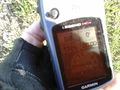
| Tue 7 Apr 2015 in 48,11: 48.7079838, 11.1690045 geohashing.info google osm bing/os kml crox |
Location
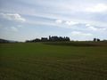
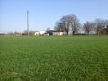
In the middle of a wheat field south of Neuburg an der Donau.
Participants
Plans
Expedition
Number four in this years bicycle hash tour (to number three and five).
I was in the hotel in Ellwangen yesterday and were looking for todays hashpoints. So, 48_10 looks convenient. Only 30 KM away, and I am exhausted enough. But - it's in a private home. OK, maybe 48_9? It's 75 kilometers (as the crow flies). Pretty far, but possible. But it's next to a skyscraper on a parking lot (hopefully) - and it is in Stuttgart. Hey, I just came from Stuttgart, I don't want to go there again. But I'm tired and I promised myself, to never go more than 100 kilometers on my bike again. 49_10 is 82 kilometers, that means 130 in reality. Maybe, I can drive part of the way by train? And - just for fun - where is 48_11?
Hey, it's near Neuburg an der Donau. I've been there before and know it as a very picturesque town. It's 81 kilometers. But look, komoot says, it's only 110 kilometers by bike, and -uh, I can't believe that - just 500 m total rise. And if it get's to far, I still can take the train from Donauwörth to Neuburg.
So the promise, not to go so far again holds just 3 days. I started following the river Jagst for a while and after 10 KM I found the first landmark, the remaining of a portal to the german limes. In Lauchheim, I had to leaf the Jagst (which had its source 10 KM further anyway) and climb the first mountain. Then I came down to Bopfingen and had immediately to go upwards again. I came to a mountain called Ipf. It houses the remaining of a celtic castle. From here I crossed the Nördlinger Ried, a landscape that formed through a meteor strike and was very flat. Just in the center of the Ried lies the medieval town Nördlingen. I had a break there to buy some picnic and do some sightseeing.
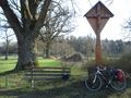
Then I followed the river Wörnitz until it flows in the Donau (Danube) at Donauwörth. There are some hills ranging immediately to the banks of the Danube, so the rest of the tour was't complete flat, but it was a quite easy going and I reached Neuburg around half past four. I decided, that that's still early enough to go to the hash before I'll look for a place for the night. So I crossed Neuburg, and after 3 kliometers I reached a country lane that runs along todays hash - field. The field was planted with young wheat (I guess) and next to the field was a farm and a woman just came out of the farm with a horse. Just next to the farm was a bench and a wayside cross where I parked the bike and waited for the lady to disappear. I usually don't hurt fresh planted fields but I ride more than 100 kilometers only to walk on that field and that was exactly what I would have told anyone, who would have asked me what I was doing. But nobody asked. I reached the hashpoint next to a power pole, took the usual pictures and hurried back to my bike. Then I returned to Neuburg to find a place for my last night of this journey.
Tracklog
Photos
a gate in the limes
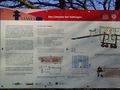
and the corresponding description
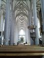
the church in Nördlingen

and a cheese shop
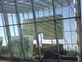
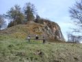
the castle in Harburg
my picnic place
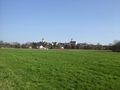
view to Neuburg
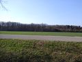
a hash field
with a bicycle parking lot next to it
proof
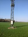
view from the hash- to the power pole
- to the farm

- to the hasher


Achievements
DODO earned the Land geohash achievement
|
DODO earned the Bicycle geohash achievement
|
DODO earned the Consecutive geohash achievement
|
And what came to my mind as I was cycling through Neuburg? Wasn't there a "Tale of two Hashes" year ago. I never thought that I would earn this one by myself.
