Difference between revisions of "2015-04-18 -32 -64"
imported>Onicofago (→Expedition) |
m (per Renaming Proposal) |
||
| (12 intermediate revisions by 2 users not shown) | |||
| Line 18: | Line 18: | ||
== Expedition == | == Expedition == | ||
| − | This expedition was special because it was the first in which the hashpoint was very near of Río Tercero city, the birthplace of yours truly. My wife decided not to accompany us this time, so after lunch and being a sunny day Juan & me got into the car and put some music to endure the 1 hour and a half | + | This expedition was special because it was the first in which the hashpoint was very near of Río Tercero city, the birthplace of yours truly. My wife decided not to accompany us this time, so after lunch and being a sunny day Juan & me got into the car and put some music to endure the 1 hour and a half drive. Also, we called my dad, who lives not far away from there, to see if he wanted to join. He agreed, dragging along his girlfriend and not understanding very much what the fuss was all about, but nonetheless wanting to share some time with his grandson. |
<br /><br /> | <br /><br /> | ||
We met near the hashpoint almost at 4pm (Saturday meetup anyone?) and after 10 min of roaming badly maintained dirt roads we arrived at a motocross track in the wild, near the river, with some guys doing their tricks. Also we saw a few abandoned structures, presumably from a construction site or something like that. It rained heavily the last few days in the region son it was muddy everywhere. | We met near the hashpoint almost at 4pm (Saturday meetup anyone?) and after 10 min of roaming badly maintained dirt roads we arrived at a motocross track in the wild, near the river, with some guys doing their tricks. Also we saw a few abandoned structures, presumably from a construction site or something like that. It rained heavily the last few days in the region son it was muddy everywhere. | ||
| Line 28: | Line 28: | ||
== Photos == | == Photos == | ||
<gallery perrow="5"> | <gallery perrow="5"> | ||
| − | Image:2015- | + | Image:2015-04-18_-32,-64_track.jpg | Motocross track. |
| − | Image:2015- | + | Image:2015-04-18_-32,-64_abandoned.jpg | Abandoned equipment and ruins. |
| − | Image:2015- | + | Image:2015-04-18_-32,-64_bike.jpg | Very close. |
| − | Image:2015- | + | Image:2015-04-18_-32,-64_mud.jpg | Muddy mud mud. |
| − | Image:2015- | + | Image:2015-04-18_-32,-64_walk.jpg | Walking to the hashpoint. |
| − | Image:2015- | + | Image:2015-04-18_-32,-64_hash.jpg | Pond, photo taken from the actual hashpoint. |
| − | Image:2015- | + | Image:2015-04-18_-32,-64_coord.jpg | Coordinates reached. |
| − | Image:2015- | + | Image:2015-04-18_-32,-64_party.jpg | Smiles. |
| + | Image:2015-04-18_-32,-64_pose.jpg | Stoopid Pose (TM). | ||
| + | Image:2015-04-18_-32,-64_views.jpg | View South from the hashpoint. | ||
| + | Image:2015-04-18_-32,-64_viewn.jpg | View North from the hashpoint. | ||
</gallery> | </gallery> | ||
| Line 42: | Line 45: | ||
{{land geohash | {{land geohash | ||
| − | | latitude = - | + | | latitude = -32 |
| longitude = -64 | | longitude = -64 | ||
| − | | date = 2015- | + | | date = 2015-04-18 |
| name = [[User:Onicofago|Onicofago]] | | name = [[User:Onicofago|Onicofago]] | ||
}} | }} | ||
| − | {{ | + | {{drag-along |
| − | | latitude = - | + | | latitude = -32 |
| longitude = -64 | | longitude = -64 | ||
| − | | date = 2015- | + | | date = 2015-04-18 |
| − | | name = [[User:Onicofago|Onicofago]] | + | | partner = Chachi, Mity and Juan |
| − | | image = 2015- | + | | name = [[User:Onicofago|Onicofago]] |
| + | | image = 2015-04-18_-32,-64_party.jpg | ||
| + | }} | ||
| + | |||
| + | {{Graticule unlocked | ||
| + | | latitude = -32 | ||
| + | | longitude = -64 | ||
| + | | date = 2015-04-18 | ||
| + | | name = [[User:Onicofago|Onicofago]] | ||
}} | }} | ||
| + | |||
| + | {{Minesweeper geohash | ||
| + | | graticule = Córdoba, Argentina | ||
| + | | ranknumber = 1 | ||
| + | | s = true | ||
| + | | name = [[User:Onicofago|Onicofago]] | ||
| + | }} | ||
[[Category:Expeditions]] | [[Category:Expeditions]] | ||
[[Category:Expeditions with photos]] | [[Category:Expeditions with photos]] | ||
[[Category:Coordinates reached]] | [[Category:Coordinates reached]] | ||
| + | {{location|AR|X}} | ||
Latest revision as of 05:05, 20 March 2024
| Sat 18 Apr 2015 in -32,-64: -32.1620383, -64.1700695 geohashing.info google osm bing/os kml crox |
Location
Wasteland in the outskirts of Río Tercero, near the river of the same name. Province of Córdoba, Argentina.
Participants
- Onicofago
- My son Juan
- Chachi (my dad) and Mity
Plans
Onicofago looked the hash up on Friday but remained unsure of the expedition because it was a long drive.
Expedition
This expedition was special because it was the first in which the hashpoint was very near of Río Tercero city, the birthplace of yours truly. My wife decided not to accompany us this time, so after lunch and being a sunny day Juan & me got into the car and put some music to endure the 1 hour and a half drive. Also, we called my dad, who lives not far away from there, to see if he wanted to join. He agreed, dragging along his girlfriend and not understanding very much what the fuss was all about, but nonetheless wanting to share some time with his grandson.
We met near the hashpoint almost at 4pm (Saturday meetup anyone?) and after 10 min of roaming badly maintained dirt roads we arrived at a motocross track in the wild, near the river, with some guys doing their tricks. Also we saw a few abandoned structures, presumably from a construction site or something like that. It rained heavily the last few days in the region son it was muddy everywhere.
The four of us walked pass the track down south into a prairie and 20 min later arrived to a little pond of mud which embodied the hashpoint in one of its shores. After three attempts to explain What Geohashing Is to my dad I finally gave up and proceed with the photos and congratulations, maybe pushing for the Drag Along Ribbon. Also, another Virgin Graticule! Yay! I might try the Minesweeper also starting at -31,-64.
After that was all a matter of hugs and kisses (and Juan having his GeoSquishy in the form of his milk bottle) and everyone returning back home. 252 km and 4,5 hours in total for another successful expedition.
Photos
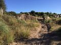
Motocross track.
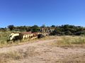
Abandoned equipment and ruins.
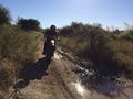
Very close.
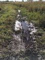
Muddy mud mud.
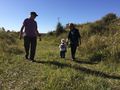
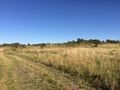
Walking to the hashpoint.
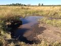
Pond, photo taken from the actual hashpoint.
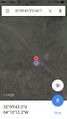
Coordinates reached.
- Error creating thumbnail: Unable to save thumbnail to destination
Smiles.
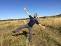
Stoopid Pose (TM).
View South from the hashpoint.
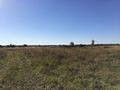
View North from the hashpoint.


Achievements
Onicofago earned the Land geohash achievement
|
Onicofago earned the Drag-along achievement
|
Onicofago earned the Graticule Unlocked Achievement
|
Onicofago achieved level 1 of the Minesweeper Geohash achievement
|