Difference between revisions of "2015-04-19 51 9"
From Geohashing
imported>GeorgDerReisende (create page) |
imported>FippeBot m (Location) |
||
| (One intermediate revision by one other user not shown) | |||
| Line 1: | Line 1: | ||
| − | |||
| − | |||
| − | |||
| − | |||
| − | |||
| − | |||
| − | |||
| − | |||
| − | |||
| − | |||
{{meetup graticule | {{meetup graticule | ||
| lat=51 | | lat=51 | ||
| Line 18: | Line 8: | ||
__NOTOC__ | __NOTOC__ | ||
== Location == | == Location == | ||
| − | + | The hash lay on a field near Hembsen. | |
== Participants == | == Participants == | ||
| − | + | ||
| − | + | [[User:GeorgDerReisende|GeorgDerReisende]] | |
== Plans == | == Plans == | ||
| − | + | ||
| + | Hitchhiking and walking. | ||
== Expedition == | == Expedition == | ||
| − | |||
| − | + | I left home at 10:10, with two trams, a bus and some walking I reached the B83. At 11:17 I started to hitchhike. With cars to Hofgeismar, Trendelburg, Godelheim and Hembsen I came near to the hash. Then I walked to the hash. Afterwards I walked to Ottbergen, there I started to hitchhike at 14:44. With a change of direction at the service station Soester Börde I arrived in Kassel at 17:44 and at home at 19:00. | |
| − | |||
== Photos == | == Photos == | ||
| − | |||
| − | |||
| − | |||
<gallery perrow="5"> | <gallery perrow="5"> | ||
| + | Image:2015-04-19 51 9 GeorgDerReisende 5381.jpg | arrived near Hembsen | ||
| + | Image:2015-04-19 51 9 GeorgDerReisende 5391.jpg | view to Hembsen | ||
| + | Image:2015-04-19 51 9 GeorgDerReisende 5416.jpg | hash comes nearer | ||
| + | Image:2015-04-19 51 9 GeorgDerReisende 5423.jpg | ... and nearer | ||
| + | Image:2015-04-19 51 9 GeorgDerReisende 5424.jpg | there it is | ||
| + | Image:2015-04-19 51 9 GeorgDerReisende 5426.jpg | east | ||
| + | Image:2015-04-19 51 9 GeorgDerReisende 5427.jpg | north | ||
| + | Image:2015-04-19 51 9 GeorgDerReisende 5428.jpg | west | ||
| + | Image:2015-04-19 51 9 GeorgDerReisende 5429.jpg | south | ||
| + | Image:2015-04-19 51 9 GeorgDerReisende 5430.jpg | the geohasher | ||
</gallery> | </gallery> | ||
| Line 44: | Line 40: | ||
<!-- Add any achievement ribbons you earned below, or remove this section --> | <!-- Add any achievement ribbons you earned below, or remove this section --> | ||
| + | {{Thumbs Up | latitude = 51 | longitude = 9 | date = 2015-04-19 | name = GeorgDerReisende }} | ||
| − | + | [[Category:Expeditions]] | |
| − | |||
| − | [[Category: | ||
| − | + | [[Category:Expeditions with photos]] | |
| − | |||
| − | |||
| − | |||
| − | |||
| − | |||
| − | |||
| − | |||
| − | |||
| − | |||
| − | |||
| − | |||
| − | |||
| − | |||
| − | |||
[[Category:Coordinates reached]] | [[Category:Coordinates reached]] | ||
| − | + | {{location|DE|NW|HX}} | |
| − | |||
| − | |||
| − | |||
| − | |||
| − | |||
| − | |||
| − | |||
| − | |||
| − | |||
| − | |||
| − | |||
| − | |||
| − | |||
| − | |||
| − | |||
| − | |||
| − | |||
Latest revision as of 03:24, 15 August 2019
| Sun 19 Apr 2015 in 51,9: 51.7078848, 9.2581882 geohashing.info google osm bing/os kml crox |
Location
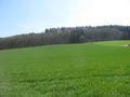
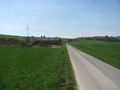
The hash lay on a field near Hembsen.
Participants
Plans
Hitchhiking and walking.
Expedition
I left home at 10:10, with two trams, a bus and some walking I reached the B83. At 11:17 I started to hitchhike. With cars to Hofgeismar, Trendelburg, Godelheim and Hembsen I came near to the hash. Then I walked to the hash. Afterwards I walked to Ottbergen, there I started to hitchhike at 14:44. With a change of direction at the service station Soester Börde I arrived in Kassel at 17:44 and at home at 19:00.
Photos
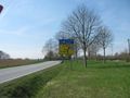
arrived near Hembsen
view to Hembsen
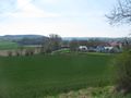
hash comes nearer
... and nearer
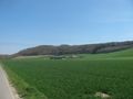
there it is

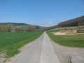
east
north
west
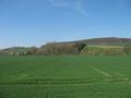
south
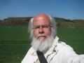
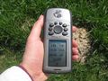
the geohasher


Achievements
GeorgDerReisende earned the Thumbs Up Geohash Achievement
|