Difference between revisions of "2015-04-29 49 8"
From Geohashing
imported>Tads (→Photos) |
imported>FippeBot m (Location) |
||
| (2 intermediate revisions by one other user not shown) | |||
| Line 45: | Line 45: | ||
Image:Tads 2015-04-29 49 8-2.jpg | many more trees | Image:Tads 2015-04-29 49 8-2.jpg | many more trees | ||
</gallery> | </gallery> | ||
| + | [https://plus.google.com/photos/+DavidScheffler/albums/5923037653150444913/6146931226540437474?pid=6146931226540437474&oid=111854160512581471503 Photo Sphere (Panorama View)] | ||
== Achievements == | == Achievements == | ||
{{#vardefine:ribbonwidth|800px}} | {{#vardefine:ribbonwidth|800px}} | ||
| − | + | {{Bicycle geohash | latitude = 49 | longitude = 8 | date = 2015-04-29 | name = [[User:tads|tads]] }} | |
| − | |||
| − | |||
| − | |||
| − | |||
| − | |||
| − | |||
| − | |||
| − | |||
| − | |||
| − | |||
| − | [[ | ||
| − | |||
[[Category:Expeditions]] | [[Category:Expeditions]] | ||
| − | |||
| − | |||
[[Category:Expeditions with photos]] | [[Category:Expeditions with photos]] | ||
| − | |||
| − | |||
| − | |||
| − | |||
[[Category:Coordinates reached]] | [[Category:Coordinates reached]] | ||
| − | + | {{location|DE|HE|DA}} | |
| − | |||
| − | |||
| − | |||
| − | |||
| − | |||
| − | |||
| − | |||
| − | |||
| − | |||
| − | |||
| − | |||
| − | |||
| − | |||
| − | |||
| − | |||
| − | |||
| − | |||
| − | |||
| − | |||
Latest revision as of 03:29, 15 August 2019
| Wed 29 Apr 2015 in 49,8: 49.8532944, 8.7348798 geohashing.info google osm bing/os kml crox |
Location
Today's geohashpoint was located in a wood close to Roßdorf near Darmstadt.
Participants
Expedition
tads enjoyed a nice 18km tour on his bike from Darmstadt to the hashpoint and back. He marked the place with a wooden X on the ground, had a rest and took some photos.
Photos
proof
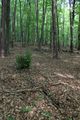
wooden marker
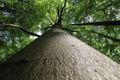
tree
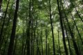
many more trees


Achievements
tads earned the Bicycle geohash achievement
|