Difference between revisions of "2015-05-07 52 1"
From Geohashing
imported>Sourcerer m (→New Expedition) |
imported>Sourcerer m (→Added Photo) |
||
| Line 22: | Line 22: | ||
<gallery perrow="5"> | <gallery perrow="5"> | ||
Image:2015-05-07_52_1_Sourcerer_1430987766712.jpg | So close but ... [http://www.openstreetmap.org/?lat=52.57317960&lon=1.71208620&zoom=16&layers=B000FTF @52.5732,1.7121] | Image:2015-05-07_52_1_Sourcerer_1430987766712.jpg | So close but ... [http://www.openstreetmap.org/?lat=52.57317960&lon=1.71208620&zoom=16&layers=B000FTF @52.5732,1.7121] | ||
| + | Image:2015-05-07_52_1_Sourcerer.jpg | Almost there | ||
</gallery> | </gallery> | ||
Revision as of 09:08, 7 May 2015
| Thu 7 May 2015 in 52,1: 52.5728423, 1.7119334 geohashing.info google osm bing/os kml crox |
Location
In a back garden in St. Anne's Crescent, Gorleston, Norfolk, UK.
Participants
Expedition
- In a private back garden. Coords not reached. -- Sourcerer (talk) @52.5732,1.7121 09:42, 7 May 2015 (GMT+01:00)
Normally 5 metre accuracy would be coordinates-reached but not today. Sadly my GPSr has GLONASS and WAAS enabled and the hashpoint was unambiguously on the other side of the garden fence - also according to Google Earth - Drat!
Photos
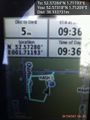
So close but ... @52.5732,1.7121
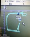
Almost there

