Difference between revisions of "2015-05-11 37 -122"
imported>Erik r (→Photos) |
imported>FippeBot m (Location) |
||
| (4 intermediate revisions by one other user not shown) | |||
| Line 4: | Line 4: | ||
| date=2015-05-11 | | date=2015-05-11 | ||
}} | }} | ||
| − | |||
__NOTOC__ | __NOTOC__ | ||
| Line 12: | Line 11: | ||
== Participants == | == Participants == | ||
| − | *[[User:Erik_r| | + | *[[User:Erik_r|Erik]] |
*[[User:meta-alt|meta-alt]] | *[[User:meta-alt|meta-alt]] | ||
| Line 26: | Line 25: | ||
<gallery perrow="5"> | <gallery perrow="5"> | ||
Image:2015-05-11_37_-122Erik_at_hashpoint.jpg | Erik standing on the hashpoint | Image:2015-05-11_37_-122Erik_at_hashpoint.jpg | Erik standing on the hashpoint | ||
| + | Image:2015-05-11 37 -122Arthurat hashpoint.jpg |Arthur standing on the hashpoint | ||
Image:2015-05-11_37_-122donkey.jpg | A donkey we met on the way | Image:2015-05-11_37_-122donkey.jpg | A donkey we met on the way | ||
Image:2015-05-11_37_-122proof.PNG | Screenshot of iPhone app | Image:2015-05-11_37_-122proof.PNG | Screenshot of iPhone app | ||
| − | Image:2015-05- | + | Image:2015-05-11 37 -122Erik and Arthur at hashpoint.jpg| Erik and Arthur at the spot |
| + | Image:2015-05-11 37 -122ArthurWithDonkeys.jpg|Donkeys once more. | ||
| + | Image:2015-05-11 37 -122Arthur Biking.jpg|Arthur on his bike. | ||
| + | |||
</gallery> | </gallery> | ||
| Line 38: | Line 41: | ||
| longitude = -122 | | longitude = -122 | ||
| date = 2015-05-11 | | date = 2015-05-11 | ||
| − | | name = | + | | name = Erik r |
}} | }} | ||
| Line 52: | Line 55: | ||
| longitude = -122 | | longitude = -122 | ||
| date = 2015-05-11 | | date = 2015-05-11 | ||
| − | | name = | + | | name = Erik r |
| bothways = true | | bothways = true | ||
| Line 70: | Line 73: | ||
[[Category:Expeditions with photos]] | [[Category:Expeditions with photos]] | ||
[[Category:Coordinates reached]] | [[Category:Coordinates reached]] | ||
| + | {{location|US|CA|SL}} | ||
Latest revision as of 03:35, 15 August 2019
| Mon 11 May 2015 in 37,-122: 37.3916227, -122.1061915 geohashing.info google osm bing/os kml crox |
Location
A sidewalk in residential Los Altos.
Participants
Plans
Simply to bike 5 miles to the hash point, and return.
Expedition
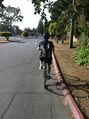
The two of us took off on bicycles from Stanford campus, the hash point being about 5 miles away. The way there was relatively uneventful, with just one wrong turn that was quickly amended. Upon arrival, we discovered that there was little interesting about this random suburban street in Los Altos. We had a spot of trouble, since Google Maps had indicated the hash point to be roughly around 407 Alvarado St., which it turns out does not in fact exist. Using GPS on foot in the near vicinity, we quickly found the point, on the sidewalk. After snapping a few photos and of course a few high-fives, we departed once again. On the return trip, we stopped to visit with some donkeys, and returned home once more.
Photos
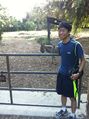
Erik standing on the hashpoint

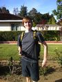
Arthur standing on the hashpoint
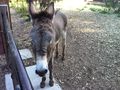
A donkey we met on the way
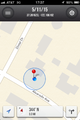
Screenshot of iPhone app

Erik and Arthur at the spot
Donkeys once more.
Arthur on his bike.


Achievements
Erik r earned the Land geohash achievement
|
meta-alt earned the Land geohash achievement
|
Erik r earned the Bicycle geohash achievement
|
meta-alt earned the Bicycle geohash achievement
|