Difference between revisions of "2015-05-11 52 1"
From Geohashing
imported>Sourcerer m ([live picture] Wading in undies to zero in. [http://www.openstreetmap.org/?lat=52.68205047&lon=1.71820700&zoom=16&layers=B000FTF @52.6821,1.7182]) |
imported>Sourcerer m ([live picture] View. [http://www.openstreetmap.org/?lat=52.68204510&lon=1.71821237&zoom=16&layers=B000FTF @52.6820,1.7182]) |
||
| Line 28: | Line 28: | ||
Image:2015-05-11_52_1_Sourcerer_1431332031859.jpg | Wading in undies to zero in. [http://www.openstreetmap.org/?lat=52.68205047&lon=1.71820700&zoom=16&layers=B000FTF @52.6821,1.7182] | Image:2015-05-11_52_1_Sourcerer_1431332031859.jpg | Wading in undies to zero in. [http://www.openstreetmap.org/?lat=52.68205047&lon=1.71820700&zoom=16&layers=B000FTF @52.6821,1.7182] | ||
| + | |||
| + | Image:2015-05-11_52_1_Sourcerer_1431332042504.jpg | View. [http://www.openstreetmap.org/?lat=52.68204510&lon=1.71821237&zoom=16&layers=B000FTF @52.6820,1.7182] | ||
</gallery> | </gallery> | ||
Revision as of 08:20, 11 May 2015
| Mon 11 May 2015 in 52,1: 52.6821113, 1.7184362 geohashing.info google osm bing/os kml crox |
Location
This off-shore point might be reachable at low tide at 08:40 local summer time. It's a spring tide and the water will go out further than usual here at Scratby, Norfolk, UK.
Participants
Expedition
- Arrived. Underpants wade needed for zeroing in! -- Sourcerer (talk) @52.6821,1.7182 09:17, 11 May 2015 (GMT+01:00)
Photos
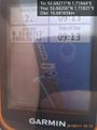
Proof. @52.6821,1.7182
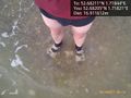
Wading in undies to zero in. @52.6821,1.7182
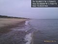
View. @52.6820,1.7182


