Difference between revisions of "2015-05-23 51 4"
imported>FelixTheCat |
imported>FippeBot m (Location) |
||
| (12 intermediate revisions by one other user not shown) | |||
| Line 4: | Line 4: | ||
| date=2015-05-23 | | date=2015-05-23 | ||
}} | }} | ||
| − | |||
| − | |||
__NOTOC__ | __NOTOC__ | ||
== Location == | == Location == | ||
| Line 17: | Line 15: | ||
== Expedition == | == Expedition == | ||
| − | The hash was about 80 km from my home. I could have driven there in about an hour, but | + | The hash was about 80 km from my home. I could have driven there in about an hour, but the weather was nice, and I'd just taken my long-distance touring bike out of storage (where it had been collecting dust for about seven years), so I thought that I could also just go by bike. Looking back, I'm not sure what possessed me to think that this was a reasonable idea, but I just packed my camera and GPS, put on my cycling shoes and headed out around noon. |
| − | The first part was rather uneventful. | + | The first part was rather uneventful, although my GPS ran out of juice after about 5 km. I bought it some new batteries in a small electronics shop in Overschie, after which it guided me through the centre of Rotterdam with all its skycrapers and busy traffic. I crossed the Nieuwe Maas using the famous Erasmus bridge. After that I headed SE towards Zwijndrecht. Crossing the Oude Maas I reached Dordrecht and turned South. Crossing yet another huge river using the Moerdijk Bridge I entered the province of Brabant. After a loooong stretch of emptiness (or at least as empty as this country gets) I entered the outskirts of the city of Breda. Crossing the southern suburbs I headed further South, towards the Belgian border. In the small village of Strijbeek I turned left and reached Strijbeekse Heide natural area. I parked my bike at the gate and walked a few hundred metres to finally reach the point. |
| − | That was a tough ride. | + | That was a tough ride. After 84 km my legs were aching, my body was covered in sweat, I had already emptied my extra-large water bottle and I was sitting on a bench in a pretty forest with not a soul in sight. I had reached the hashpoint, on Mouseover Day! |
| − | I really wasn't feeling like cycling any more, but I had to get back home somehow. So I got back on my bike, and set off again. The first part was rather uneventful again. Had an ice cream and a bottle of Mountain Dew at a service station, and rode the same route back. Reaching Dordrecht, I decided to head into the city centre to get some food. After a nice and hot Thai | + | I really wasn't feeling like cycling any more, but I had to get back home somehow. So I got back on my bike, and set off again. The first part was rather uneventful again. Had an ice cream and a bottle of Mountain Dew at a service station, and rode the same route back. Reaching Dordrecht, I decided to head into the city centre to get some food. After a nice and hot Thai curry I headed North towards Papendrecht, trying to avoid having to go through the centre of Rotterdam again. Not being able to find an easy route back to Delft I decided to let my GPS guide me. In the end it did drag me through Rotterdam yet again, crossing the Erasmus Bridge once more. Finally, I reached Delft around 23:00, having covered a total of 172 km in one day. |
| − | |||
| − | |||
| − | |||
== Photos == | == Photos == | ||
| − | |||
| − | |||
| − | |||
<gallery perrow="5"> | <gallery perrow="5"> | ||
| + | Image:2015-05-23 51 4 FelixTheCat 1.JPG | The famous Erasmus Bridge in central Rotterdam. | ||
| + | Image:2015-05-23 51 4 FelixTheCat 2.JPG | Moerdijk Bridge crossing towards Brabant. | ||
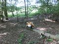
| + | Image:2015-05-23 51 4 FelixTheCat 3.JPG | My bike near the hash. | ||
| + | Image:2015-05-23 51 4 FelixTheCat 4.JPG | The entrance sign near the natural area. | ||
| + | Image:2015-05-23 51 4 FelixTheCat 5.JPG | It's a very pretty natural area indeed. | ||
| + | Image:2015-05-23 51 4 FelixTheCat 6.JPG | Lloyd posing at the hash. | ||
| + | Image:2015-05-23 51 4 FelixTheCat 7.JPG | GPS coordinates. | ||
| + | Image:2015-05-23 51 4 FelixTheCat 8.JPG | I had to use this ferry to get from Dordrecht to Papendrecht. | ||
| + | Image:2015-05-23 51 4 FelixTheCat 9.JPG | This is an Ark, apparently made to the original Biblical specs by some guy in Dordrecht. | ||
</gallery> | </gallery> | ||
== Achievements == | == Achievements == | ||
{{#vardefine:ribbonwidth|800px}} | {{#vardefine:ribbonwidth|800px}} | ||
| − | + | {{bicycle geohash | |
| + | | latitude = 51 | ||
| + | | longitude = 4 | ||
| + | | date = 2015-05-23 | ||
| + | | name = [[User:FelixTheCat|FelixTheCat]] ([[User talk:FelixTheCat|talk]]) | ||
| + | | distance = 172 km | ||
| + | | bothways = true | ||
| + | }} | ||
| + | {{Geohashing Day | ||
| − | + | | latitude = 51 | |
| − | + | | longitude = 4 | |
| − | [[ | + | | year = 2015 |
| + | | coorddate= 2015-05-23 | ||
| + | | mouseover = true | ||
| + | | name = [[User:FelixTheCat|FelixTheCat]] ([[User talk:FelixTheCat|talk]]) | ||
| + | }} | ||
| − | |||
| − | |||
| − | |||
| − | |||
| − | |||
| − | |||
| − | |||
| − | |||
[[Category:Expeditions]] | [[Category:Expeditions]] | ||
| − | |||
[[Category:Expeditions with photos]] | [[Category:Expeditions with photos]] | ||
| − | |||
| − | |||
| − | |||
| − | |||
| − | |||
[[Category:Coordinates reached]] | [[Category:Coordinates reached]] | ||
| − | + | {{location|NL|NB}} | |
| − | |||
| − | |||
| − | |||
| − | |||
| − | |||
| − | |||
| − | |||
| − | |||
| − | |||
| − | |||
| − | |||
| − | |||
| − | |||
| − | |||
| − | |||
| − | |||
| − | |||
Latest revision as of 03:43, 15 August 2019
| Sat 23 May 2015 in 51,4: 51.4992878, 4.8056535 geohashing.info google osm bing/os kml crox |
Location
Strijbeekse Heide, just outside Strijbeek. Municipality of Alphen-Chaam.
Participants
Plans
As usual, cycle to the hash and see if it's accessible. This time using my long-distance touring bike, for two reasons: the hash was at least 80 km from my home, and my regular everyday bike had been stolen after last week's expedition.
Expedition
The hash was about 80 km from my home. I could have driven there in about an hour, but the weather was nice, and I'd just taken my long-distance touring bike out of storage (where it had been collecting dust for about seven years), so I thought that I could also just go by bike. Looking back, I'm not sure what possessed me to think that this was a reasonable idea, but I just packed my camera and GPS, put on my cycling shoes and headed out around noon.
The first part was rather uneventful, although my GPS ran out of juice after about 5 km. I bought it some new batteries in a small electronics shop in Overschie, after which it guided me through the centre of Rotterdam with all its skycrapers and busy traffic. I crossed the Nieuwe Maas using the famous Erasmus bridge. After that I headed SE towards Zwijndrecht. Crossing the Oude Maas I reached Dordrecht and turned South. Crossing yet another huge river using the Moerdijk Bridge I entered the province of Brabant. After a loooong stretch of emptiness (or at least as empty as this country gets) I entered the outskirts of the city of Breda. Crossing the southern suburbs I headed further South, towards the Belgian border. In the small village of Strijbeek I turned left and reached Strijbeekse Heide natural area. I parked my bike at the gate and walked a few hundred metres to finally reach the point.
That was a tough ride. After 84 km my legs were aching, my body was covered in sweat, I had already emptied my extra-large water bottle and I was sitting on a bench in a pretty forest with not a soul in sight. I had reached the hashpoint, on Mouseover Day!
I really wasn't feeling like cycling any more, but I had to get back home somehow. So I got back on my bike, and set off again. The first part was rather uneventful again. Had an ice cream and a bottle of Mountain Dew at a service station, and rode the same route back. Reaching Dordrecht, I decided to head into the city centre to get some food. After a nice and hot Thai curry I headed North towards Papendrecht, trying to avoid having to go through the centre of Rotterdam again. Not being able to find an easy route back to Delft I decided to let my GPS guide me. In the end it did drag me through Rotterdam yet again, crossing the Erasmus Bridge once more. Finally, I reached Delft around 23:00, having covered a total of 172 km in one day.
Photos
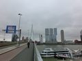
The famous Erasmus Bridge in central Rotterdam.
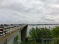
Moerdijk Bridge crossing towards Brabant.
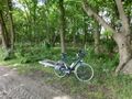
My bike near the hash.
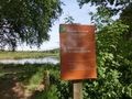
The entrance sign near the natural area.
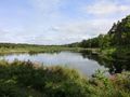
It's a very pretty natural area indeed.
Lloyd posing at the hash.
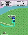
GPS coordinates.
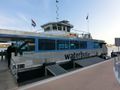
I had to use this ferry to get from Dordrecht to Papendrecht.
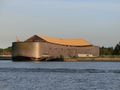
This is an Ark, apparently made to the original Biblical specs by some guy in Dordrecht.


Achievements
FelixTheCat (talk) earned the Bicycle geohash achievement
|
FelixTheCat (talk) earned the 2015 Mouse Over Day achievement
|