Difference between revisions of "2015-05-29 41 -88"
imported>Mystrsyko (Created page with "{{subst:Expedition |lat = 41 |lon = -88 |date = 2015-05-29 }}") |
imported>Mystrsyko (Finished!) |
||
| Line 1: | Line 1: | ||
| − | |||
| − | |||
| − | |||
| − | |||
| − | |||
| − | |||
| − | |||
| − | |||
| − | |||
| − | |||
{{meetup graticule | {{meetup graticule | ||
| lat=41 | | lat=41 | ||
| Line 15: | Line 5: | ||
}} | }} | ||
| − | + | ||
__NOTOC__ | __NOTOC__ | ||
== Location == | == Location == | ||
| − | + | Just off Big Woods Road in Aurora, IL | |
== Participants == | == Participants == | ||
| − | + | [[User:Rookiek13|Rookiek13]] | |
| − | |||
| − | |||
| − | |||
== Expedition == | == Expedition == | ||
| − | + | My geohashing brother had visited the day before and with the thought fresh in my mind, I dug out the trusty hand-me-down gps. A quick check of the site told me that the point wasn't too far away. As I have the sense of direction of a baked potato, I texted my closest evil minion to assist me in getting to the hashpoint and not one in Bangkok. We hopped in her car and drove down to the point. It was located in a small subdivision, but there was ample room to park so we hopped out and began doing the hash dance. Unfortunately I had only used the gps for geocacheing and it does not have a way to input coordinates correctly, so I had to guess that I was close enough. With bored housewives staring at us, we set up for a few quick photos before hightailing it out of there for noms. | |
| − | |||
| − | |||
== Photos == | == Photos == | ||
| − | + | ||
| − | |||
| − | |||
<gallery perrow="5"> | <gallery perrow="5"> | ||
| + | Image:2015-05-29 41 -88 hashscots.JPG|The group assembles | ||
| + | Image:2015-05-29 41 -88 grins.JPG|Us at the point | ||
| + | Image:2015-05-29 41 -88 screenshot.png|Proof | ||
</gallery> | </gallery> | ||
== Achievements == | == Achievements == | ||
{{#vardefine:ribbonwidth|800px}} | {{#vardefine:ribbonwidth|800px}} | ||
| − | + | {{land geohash | |
| − | |||
| − | + | | latitude = 41 | |
| − | + | | longitude = -88 | |
| − | + | | date = 2015-05-29 | |
| + | | name = Rookiek13 | ||
| − | + | }} | |
| − | |||
| − | |||
| − | |||
| − | |||
| − | |||
| − | |||
[[Category:Expeditions]] | [[Category:Expeditions]] | ||
| − | |||
[[Category:Expeditions with photos]] | [[Category:Expeditions with photos]] | ||
| − | |||
| − | |||
| − | |||
| − | |||
| − | |||
[[Category:Coordinates reached]] | [[Category:Coordinates reached]] | ||
| − | |||
| − | |||
| − | |||
| − | |||
| − | |||
| − | |||
| − | |||
| − | |||
| − | |||
| − | |||
| − | |||
| − | |||
| − | |||
| − | |||
| − | |||
| − | |||
| − | |||
| − | |||
Revision as of 21:40, 5 June 2015
| Fri 29 May 2015 in 41,-88: 41.8078270, -88.2518924 geohashing.info google osm bing/os kml crox |
Location
Just off Big Woods Road in Aurora, IL
Participants
Expedition
My geohashing brother had visited the day before and with the thought fresh in my mind, I dug out the trusty hand-me-down gps. A quick check of the site told me that the point wasn't too far away. As I have the sense of direction of a baked potato, I texted my closest evil minion to assist me in getting to the hashpoint and not one in Bangkok. We hopped in her car and drove down to the point. It was located in a small subdivision, but there was ample room to park so we hopped out and began doing the hash dance. Unfortunately I had only used the gps for geocacheing and it does not have a way to input coordinates correctly, so I had to guess that I was close enough. With bored housewives staring at us, we set up for a few quick photos before hightailing it out of there for noms.
Photos
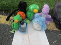
The group assembles

Us at the point
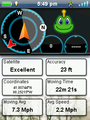
Proof


Achievements
Rookiek13 earned the Land geohash achievement
|