Difference between revisions of "2015-05-30 52 1"
From Geohashing
imported>Sourcerer m ([live] Arrived.) |
imported>Sourcerer m ([live picture] Proof [http://www.openstreetmap.org/?lat=52.70805717&lon=1.24032319&zoom=16&layers=B000FTF @52.7081,1.2403]) |
||
| Line 24: | Line 24: | ||
<gallery perrow="5"> | <gallery perrow="5"> | ||
| + | |||
| + | Image:2015-05-30_52_1_Sourcerer_1432941698866.jpg | Proof [http://www.openstreetmap.org/?lat=52.70805717&lon=1.24032319&zoom=16&layers=B000FTF @52.7081,1.2403] | ||
</gallery> | </gallery> | ||
Revision as of 23:23, 29 May 2015
| Sat 30 May 2015 in 52,1: 52.7080893, 1.2402456 geohashing.info google osm bing/os kml crox |
Location
In a field north of Horsford, Norfolk, UK.
Participants
Plans
This looks reachable unless crops block access.
Expedition
- Arrived. -- Sourcerer (talk) @52.7081,1.2403 00:22, 30 May 2015 (GMT+01:00)
Photos
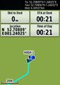
Proof @52.7081,1.2403

Other geohashing expeditions on the same day
Expeditions and Plans
| 2015-05-30 | ||
|---|---|---|
| Atlanta, Georgia | NWoodruff | In the flood plain of a subdivision East of Panthersville. |
| Mannheim, Germany | DODO | In a vineyard in the Höllenbrand between Gundersheim and Westhofen |
| Norwich, United Kingdom | Sourcerer | In a field north of Horsford, Norfolk, UK. |
| Sheffield, United Kingdom | GydeonMylls | In a pile of glass in Knottingley |