Difference between revisions of "2015-06-01 52 1"
imported>Sourcerer m (→Photo Added) |
imported>Sourcerer m (→Expedition Detail) |
||
| Line 23: | Line 23: | ||
*Failed. Vegetation and terrain. -- [[User:Sourcerer|Sourcerer]] ([[User talk:Sourcerer|talk]]) [http://www.openstreetmap.org/?lat=52.49762177&lon=1.63029492&zoom=16&layers=B000FTF @52.4976,1.6303] 22:15, 1 June 2015 (GMT+01:00) | *Failed. Vegetation and terrain. -- [[User:Sourcerer|Sourcerer]] ([[User talk:Sourcerer|talk]]) [http://www.openstreetmap.org/?lat=52.49762177&lon=1.63029492&zoom=16&layers=B000FTF @52.4976,1.6303] 22:15, 1 June 2015 (GMT+01:00) | ||
| − | After setting out early, there was still useful daylight. The woodland was surrounded by a drainage moat. I | + | After setting out early, there was still useful daylight. The woodland was surrounded by a drainage moat. I made four attempts to cross the moat. Two were successful. The first lead to very soft wet ground and the potential route was choked with fallen branches, nettles and brambles. The second was similar with waist high nettles and 200 metres of very uncertain terrain to cross. With failing light and deteriorating weather I abandoned the attempt. |
My route took me closer to [[2012-02-20 52 1]] that I got to today's point. Very déjà vu and almost a retrohash. | My route took me closer to [[2012-02-20 52 1]] that I got to today's point. Very déjà vu and almost a retrohash. | ||
Revision as of 22:48, 1 June 2015
| Mon 1 Jun 2015 in 52,1: 52.5001180, 1.6271177 geohashing.info google osm bing/os kml crox |
Location
Close to a public footpath in a woodland marsh, Wheatacre, Norfolk, UK.
Participants
Plans
Expedition one of two spanning midnight. ETA 23:00. 2015-06-01 52 1 2015-06-02 52 1
The hashpoint is close to a public right of way but might be under water. Bad weather is forecast.
Expedition
- Failed. Vegetation and terrain. -- Sourcerer (talk) @52.4976,1.6303 22:15, 1 June 2015 (GMT+01:00)
After setting out early, there was still useful daylight. The woodland was surrounded by a drainage moat. I made four attempts to cross the moat. Two were successful. The first lead to very soft wet ground and the potential route was choked with fallen branches, nettles and brambles. The second was similar with waist high nettles and 200 metres of very uncertain terrain to cross. With failing light and deteriorating weather I abandoned the attempt.
My route took me closer to 2012-02-20 52 1 that I got to today's point. Very déjà vu and almost a retrohash.
Photos
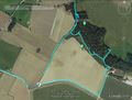
Google Earth Track Log
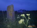
The standing stone


Other geohashing expeditions on the same day
Expeditions and Plans
| 2015-06-01 | ||
|---|---|---|
| Newark, New Jersey | Someone went | University Ave. in Newark, adjacent to the Rutgers Newark campus. Shouting ... |
| Norwich, United Kingdom | Sourcerer | Close to a public footpath in a woodland marsh, Wheatacre, Norfolk, UK. |
| Manchester, United Kingdom | Angel | Looks like this is near to both Three Sisters and Viridor Wood. Not sure if... |