Difference between revisions of "2015-06-10 48 8"
From Geohashing
imported>RecentlyChanged ([live picture] The four parts of forest around me. The light part (south) [http://www.openstreetmap.org/?lat=48.79563689&lon=8.28856230&zoom=16&layers=B000FTF @48.7956,8.2886]) |
imported>FippeBot m (Location) |
||
| (5 intermediate revisions by 2 users not shown) | |||
| Line 43: | Line 43: | ||
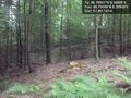
Image:2015-06-10_48_8_RecentlyChanged_1433963095000.jpg | The four parts of forest around me. The light part (south) [http://www.openstreetmap.org/?lat=48.79563689&lon=8.28856230&zoom=16&layers=B000FTF @48.7956,8.2886] | Image:2015-06-10_48_8_RecentlyChanged_1433963095000.jpg | The four parts of forest around me. The light part (south) [http://www.openstreetmap.org/?lat=48.79563689&lon=8.28856230&zoom=16&layers=B000FTF @48.7956,8.2886] | ||
| + | |||
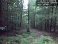
| + | Image:2015-06-10_48_8_RecentlyChanged_1433963106000.jpg | The dark part. (west) [http://www.openstreetmap.org/?lat=48.79563689&lon=8.28845501&zoom=16&layers=B000FTF @48.7956,8.2885] | ||
| + | |||
| + | Image:2015-06-10_48_8_RecentlyChanged_1433963100000.jpg | Another part (east) [http://www.openstreetmap.org/?lat=48.79595876&lon=8.28907728&zoom=16&layers=B000FTF @48.7960,8.2891] | ||
| + | |||
| + | Image:2015-06-10_48_8_RecentlyChanged_1433963112000.jpg | The last part (north) [http://www.openstreetmap.org/?lat=48.79562616&lon=8.28849792&zoom=16&layers=B000FTF @48.7956,8.2885] | ||
</gallery> | </gallery> | ||
| Line 49: | Line 55: | ||
<!-- Add any achievement ribbons you earned below, or remove this section --> | <!-- Add any achievement ribbons you earned below, or remove this section --> | ||
| − | |||
| − | |||
| − | |||
| − | |||
| − | |||
| − | |||
| − | |||
| − | |||
| − | |||
| − | |||
| − | |||
| − | |||
| − | |||
[[Category:Expeditions]] | [[Category:Expeditions]] | ||
| − | |||
[[Category:Expeditions with photos]] | [[Category:Expeditions with photos]] | ||
| − | |||
| − | |||
| − | |||
| − | |||
| − | |||
[[Category:Coordinates reached]] | [[Category:Coordinates reached]] | ||
| − | + | {{location|DE|BW|RA}} | |
| − | |||
| − | |||
| − | |||
| − | |||
| − | |||
| − | |||
| − | |||
| − | |||
| − | |||
| − | |||
| − | |||
| − | |||
| − | |||
| − | |||
| − | |||
| − | |||
| − | |||
Latest revision as of 03:59, 15 August 2019
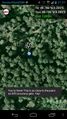
| Wed 10 Jun 2015 in 48,8: 48.7956071, 8.2885037 geohashing.info google osm bing/os kml crox |
Location
Gaggenau, forest
Participants
Plans
Take the tram there and back.
Expedition
Tracklog
Photos
I did it! Proof.
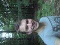
Stupid grin :) @48.7955,8.2884
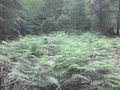
The four parts of forest around me. The light part (south) @48.7956,8.2886
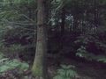
The dark part. (west) @48.7956,8.2885
Another part (east) @48.7960,8.2891
The last part (north) @48.7956,8.2885


