Difference between revisions of "2015-06-11 48 16"
imported>B2c (→Participants) |
imported>FippeBot m (Location) |
||
| (24 intermediate revisions by 4 users not shown) | |||
| Line 1: | Line 1: | ||
| − | |||
| − | |||
| − | |||
| − | |||
| − | |||
| − | |||
| − | |||
| − | |||
| − | |||
{{meetup graticule | {{meetup graticule | ||
| lat=48 | | lat=48 | ||
| Line 14: | Line 5: | ||
}} | }} | ||
| − | + | ||
| − | + | [[Image:2015-06-11-48_16-hashpoint_new.jpg | thumb | left | Hashpoint right between the branch bank and the farmers market. ]] | |
| + | |||
| + | |||
== Location == | == Location == | ||
| − | + | Atadxart | |
| + | |||
| + | Corner of Schottengasse and Helferstorfergasse in the first district of Vienna. | ||
== Participants == | == Participants == | ||
| − | + | * [[User:Atadxart|atadxart]] arrived at 1830 GMT+2 | |
| − | + | * [[User:Micsnare|Micsnare]] arrived at 17:24 GMT+2 | |
| − | [[User:Atadxart|atadxart]] | + | * [[User:Crankl|Crankl]] arrived at 17:24 GMT+2 |
| − | [[User:Micsnare|Micsnare]] | + | * [[User:B2c|B2c]] arrived at 17:24 GMT+2 |
| − | [[User:Crankl|Crankl]] | + | |
| − | [[User:B2c|B2c]] | ||
== Plans == | == Plans == | ||
| − | + | === [[User:Micsnare|Micsnare]], [[User:B2c|B2c]] and [[User:Crankl|Crankl]] plans === | |
| + | |||
| + | It was Wednesday evening when [[User:B2c|B2c]] wrote, that the next hash would be a perfect candidate to claim the Walk geohash achievement, so another trip was planned. | ||
| + | |||
== Expedition == | == Expedition == | ||
| − | + | === [[User:Atadxart|atadxart]] Expedition: === | |
| + | |||
| + | Going by Public Transport I (atadxart) arrived at about 1830 local time and tried to get a photo with the coordinates on my gps but there was a very bad GPS signal so I was going around so I am sure I got the location. | ||
| + | On a traffic sign pole nearby I placed a poster. | ||
| + | |||
| + | |||
| + | === [[User:Micsnare|Micsnare]], [[User:B2c|B2c]] and [[User:Crankl|Crankl]] Expedition: === | ||
| + | |||
| + | As we all planned to walk to the hash after work, [[User:Micsnare|Micsnare]] had to walk about an hour* (*Google maps said 1h5minutes but Micsnare made it in 47 minutes -- woot) to reach the office of [[User:B2c|B2c]] and [[User:Crankl|Crankl]]. | ||
| + | |||
| + | When she arrived, we packed up and started our walk to the hash, [[User:Micsnare|Micsnare]] decided to do some “sightseeing” and made some photographs of some landmarks around the Ring. | ||
| + | |||
| + | The walk took us about half an hour, the hash was easy to find but hard to claim because the GPS signal was very unreliable, after some tries we finally were able to get the proof. | ||
| − | + | Part 2 of the plan was to claim the Pub Geohash achievement. In the same street as the hash there is a pub called “The Pub” so the choice was obvious. | |
| − | |||
| − | |||
| − | <gallery perrow=" | + | As usual we finished the trip with some cold beers, but this time we were able to claim the achievement. :-) |
| + | |||
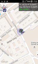
| + | == Tracklog == | ||
| + | === Micsnare, Crankl, B2c === | ||
| + | [[File:2015-06-11-48_16-tracklog.jpg]] | ||
| + | |||
| + | |||
| + | == Photos == | ||
| + | === Micsnare, Crankl, B2c === | ||
| + | <gallery caption="Photo Gallery" widths="320px" heights="213px" perrow="3"> | ||
| + | Image:2015-06-11-48_16-arsenal_new.jpg | Arsenal, the old munitions depot. | ||
| + | Image:2015-06-11-48_16-arsenalturm_new.jpg | Radio tower. | ||
| + | Image:2015-06-11-48_16-belveder_new.jpg | The Belvedere, ye olde royal summer residence. | ||
| + | Image:2015-06-11-48_16-schwarzenbergbrunnen2_new.jpg | Schwarzenbergplatz, russian war memorial. | ||
| + | Image:2015-06-11-48_16-burgtheater_new.jpg | Burgtheater, probably the most famous theatre in Vienna. | ||
| + | Image:2015-06-11-48_16-parlament_new.jpg | The parliament. | ||
| + | Image:2015-06-11-48_16-hashpoint_new.jpg | Hashpoint right between the branch bank and the farmers market. | ||
| + | Image:2015-06-11-48_16-grin_new.jpg | Stupid grin (tm). Pub in the background. | ||
| + | Image:2015-06-11-48_16-pub_new.jpg | The Pub. Literally. | ||
| + | Image:Screenshot_2015-06-11-17-23-00.png | Proof. | ||
| + | Image:Screenshot_2015-06-11-17-23-14.png | More proof. | ||
</gallery> | </gallery> | ||
| + | |||
== Achievements == | == Achievements == | ||
| + | {{#vardefine:ribbonwidth|800px}} | ||
| + | |||
| + | * [[User:Micsnare|Micsnare]] | ||
| + | {{pub geohash|name=micsnare|latitude=48|longitude=16|date=2015-06-11}} | ||
| + | |||
| + | * [[User:B2c|B2c]] | ||
| + | {{pub geohash|name=B2c|latitude=48|longitude=16|date=2015-06-11}} | ||
| + | |||
| + | * [[User:Crankl|Crankl]] | ||
| + | {{pub geohash|name=Crankl|latitude=48|longitude=16|date=2015-06-11}} | ||
| + | |||
| + | |||
| + | * [[User:Micsnare|Micsnare]] | ||
| + | {{Walk geohash|name=micsnare|latitude=48|longitude=16|date=2015-06-11}} | ||
| + | |||
| + | * [[User:B2c|B2c]] | ||
| + | {{Walk geohash|name=B2c|latitude=48|longitude=16|date=2015-06-11}} | ||
| + | |||
| + | * [[User:Crankl|Crankl]] | ||
| + | {{Walk geohash|name=Crankl|latitude=48|longitude=16|date=2015-06-11}} | ||
| + | |||
| − | + | * [[User:Crankl|Crankl]] | |
| − | + | {{Earliest geohasher | |
| + | | latitude = 48 | ||
| + | | longitude = 16 | ||
| + | | date = 2015-06-11 | ||
| + | | name = Crankl | ||
| + | }} | ||
| + | * [[User:B2c|B2c]] | ||
| + | {{Earliest geohasher | ||
| + | | latitude = 48 | ||
| + | | longitude = 16 | ||
| + | | date = 2015-06-11 | ||
| + | | name = B2c | ||
| + | }} | ||
| − | + | * [[User:Micsnare|Micsnare]] | |
| + | {{Earliest geohasher | ||
| + | | latitude = 48 | ||
| + | | longitude = 16 | ||
| + | | date = 2015-06-11 | ||
| + | | name = Micsnare | ||
| + | }} | ||
| − | |||
| − | |||
| − | |||
| − | |||
| − | |||
[[Category:Expeditions]] | [[Category:Expeditions]] | ||
| − | |||
[[Category:Expeditions with photos]] | [[Category:Expeditions with photos]] | ||
| − | |||
| − | |||
| − | |||
| − | |||
[[Category:Coordinates reached]] | [[Category:Coordinates reached]] | ||
| − | + | {{location|AT|W}} | |
| − | |||
| − | |||
| − | |||
| − | |||
| − | |||
| − | |||
| − | |||
| − | |||
| − | |||
| − | |||
| − | |||
| − | |||
| − | |||
| − | |||
| − | |||
| − | |||
Latest revision as of 04:00, 15 August 2019
| Thu 11 Jun 2015 in 48,16: 48.2128956, 16.3635839 geohashing.info google osm bing/os kml crox |

Contents
Location
Atadxart
Corner of Schottengasse and Helferstorfergasse in the first district of Vienna.
Participants
- atadxart arrived at 1830 GMT+2
- Micsnare arrived at 17:24 GMT+2
- Crankl arrived at 17:24 GMT+2
- B2c arrived at 17:24 GMT+2
Plans
Micsnare, B2c and Crankl plans
It was Wednesday evening when B2c wrote, that the next hash would be a perfect candidate to claim the Walk geohash achievement, so another trip was planned.
Expedition
atadxart Expedition:
Going by Public Transport I (atadxart) arrived at about 1830 local time and tried to get a photo with the coordinates on my gps but there was a very bad GPS signal so I was going around so I am sure I got the location. On a traffic sign pole nearby I placed a poster.
Micsnare, B2c and Crankl Expedition:
As we all planned to walk to the hash after work, Micsnare had to walk about an hour* (*Google maps said 1h5minutes but Micsnare made it in 47 minutes -- woot) to reach the office of B2c and Crankl.
When she arrived, we packed up and started our walk to the hash, Micsnare decided to do some “sightseeing” and made some photographs of some landmarks around the Ring.
The walk took us about half an hour, the hash was easy to find but hard to claim because the GPS signal was very unreliable, after some tries we finally were able to get the proof.
Part 2 of the plan was to claim the Pub Geohash achievement. In the same street as the hash there is a pub called “The Pub” so the choice was obvious.
As usual we finished the trip with some cold beers, but this time we were able to claim the achievement. :-)
Tracklog
Micsnare, Crankl, B2c

Photos
Micsnare, Crankl, B2c
- Photo Gallery
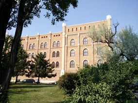
Arsenal, the old munitions depot.
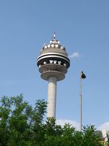
Radio tower.
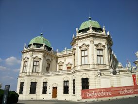
The Belvedere, ye olde royal summer residence.
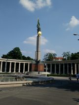
Schwarzenbergplatz, russian war memorial.
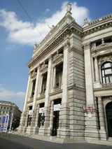
Burgtheater, probably the most famous theatre in Vienna.
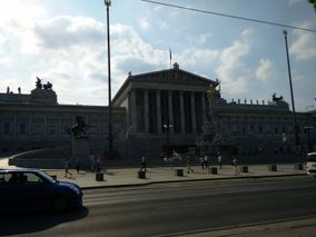
The parliament.
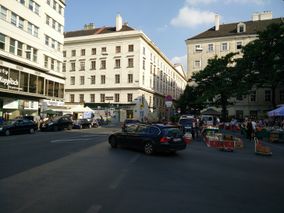
Hashpoint right between the branch bank and the farmers market.
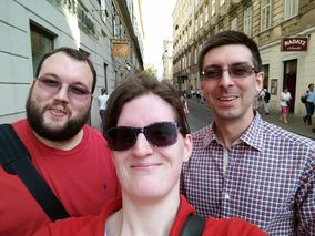
Stupid grin (tm). Pub in the background.
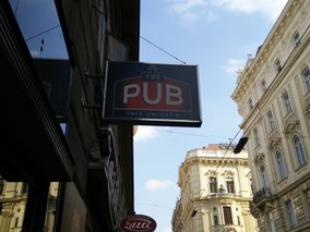
The Pub. Literally.
Proof.
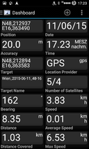
More proof.


Achievements
micsnare earned the Pub Geohash Achievement
|
B2c earned the Pub Geohash Achievement
|
Crankl earned the Pub Geohash Achievement
|
micsnare earned the Walk geohash Achievement
|
B2c earned the Walk geohash Achievement
|
Crankl earned the Walk geohash Achievement
|
Crankl earned the Earliest geohasher achievement
|
B2c earned the Earliest geohasher achievement
|
Micsnare earned the Earliest geohasher achievement
|