Difference between revisions of "2015-06-24 48 16"
From Geohashing
imported>FippeBot m (Location) |
m |
||
| Line 61: | Line 61: | ||
{{walk geohash | latitude = 48 | longitude = 16 | date = 2015-06-24 | distance = 4.1km | name = Datschech }} | {{walk geohash | latitude = 48 | longitude = 16 | date = 2015-06-24 | distance = 4.1km | name = Datschech }} | ||
| − | |||
| − | |||
| − | |||
| − | |||
| − | |||
| − | |||
| − | |||
| − | |||
| − | |||
| − | |||
| − | |||
[[Category:Expeditions]] | [[Category:Expeditions]] | ||
| − | |||
[[Category:Expeditions with photos]] | [[Category:Expeditions with photos]] | ||
| − | |||
| − | |||
| − | |||
| − | |||
| − | |||
[[Category:Coordinates reached]] | [[Category:Coordinates reached]] | ||
| − | |||
| − | |||
| − | |||
| − | |||
| − | |||
| − | |||
| − | |||
| − | |||
| − | |||
| − | |||
| − | |||
| − | |||
| − | |||
| − | |||
| − | |||
| − | |||
| − | |||
| − | |||
{{location|AT|NÖ|KO}} | {{location|AT|NÖ|KO}} | ||
Latest revision as of 15:00, 22 September 2021
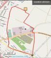
| Wed 24 Jun 2015 in 48,16: 48.3491501, 16.3503810 geohashing.info google osm bing/os kml crox |
Location
in a cropfield near Korneuburg
Participants
Plans
Expedition
- this time i succeeded, but again my gear (sgs2) wouldn't play along and on the lcation of the hp it froze right after i made the screenshot. -- Datschech (talk) 17:16, 24 June 2015 (EDT)
Tracklog
tron done by running whereever possible

Photos
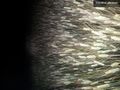
oh my. cropfield. again
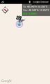
some proof

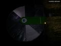
angry again, but successfil
aliens landed here, please take me with you...

now that's my ride home... or at least i wished it was.


Achievements
Datschech earned the Land geohash achievement
|
Datschech earned the Tron achievement
|
Datschech earned the Walk geohash Achievement
|