Difference between revisions of "2015-06-26 42 -78"
imported>FippeBot m (Location) |
Pedalpusher (talk | contribs) m (→Photos: adjusted grid) |
||
| (2 intermediate revisions by one other user not shown) | |||
| Line 19: | Line 19: | ||
== Photos == | == Photos == | ||
| − | <gallery perrow=" | + | <gallery perrow="6"> |
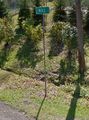
Image: 2015-06-26 hashView.jpg | View of the hash. I thought it was more in the middle of the road, but it was closer to the shoulder next to the big arrow sign. | Image: 2015-06-26 hashView.jpg | View of the hash. I thought it was more in the middle of the road, but it was closer to the shoulder next to the big arrow sign. | ||
Image: 2015-06-26 gps.jpg | Made it in a straight line, with room left over to make the turn on Grover Rd. | Image: 2015-06-26 gps.jpg | Made it in a straight line, with room left over to make the turn on Grover Rd. | ||
| Line 46: | Line 46: | ||
| longitude = -78 | | longitude = -78 | ||
| date = 2015-06-26 | | date = 2015-06-26 | ||
| − | | tracklog = | + | | tracklog = {{canonicalurl:File:2015-06-26 tronRoute.jpg}} |
| possessive = his | | possessive = his | ||
| name = Pedalpusher | | name = Pedalpusher | ||
Latest revision as of 23:14, 12 June 2020
| Fri 26 Jun 2015 in 42,-78: 42.7247405, -78.6536795 geohashing.info google osm bing/os kml crox |
Location
Middle of Mill Rd, East of Jewettville
Participants
Expedition
I saw the hash for today was closer than usual and within my range for a bike ride. It was a perfect day for a bike ride too. Always on the lookout to make things more interesting, I saw I could make this into a Tron, but I knew it wouldn't be easy due to a steep ridge I would have to ride over on the way back.
After work, I got ready and wrote out my directions. My initial plan was to make my way back to Cole Rd and finish on a route I normally take, riding through Boston(NY). I rode to the hash without any trouble taking a route that was relatively flat. Getting to the intersection with the hash, I got my pictures without getting off my bike to preserve the Tron. I then started the return trip and made it back to Rt. 240 without trouble, but once I hit Behm Rd, the road tilted WAY up. I bet the grade was over 10% in places but I impressed myself by not having to get off and rest/walk...even if I was only going 4 MPH.
Finally getting up the ridge and making it to Cole Rd, I knew I was too tired to go the whole planned route, so I cut the route in half and made my way down the other side of the ridge to North Boston instead. It was fortunate I did that because I found a restaurant that I didn't know existed that I'll have to try at some point.
I made it home and found my wife made Pho (from scratch) for dinner.
The hash being at the intersection of Mill and Grover Roads, I'm issuing a Tale of Two challenge for Mill.
Photos
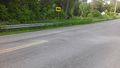
View of the hash. I thought it was more in the middle of the road, but it was closer to the shoulder next to the big arrow sign.
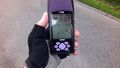
Made it in a straight line, with room left over to make the turn on Grover Rd.
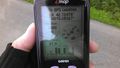
Accuracy.
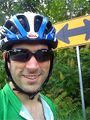
Standard stupid grin.
I made the turn onto Grover before taking a picture of the street sign so it was too late to go back. I took this off google streetview.
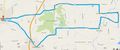
With no connector cord for my GPS, I have to create the Tron-route manually.


Ribbons
This user earned the Land geohash achievement
|
Pedalpusher earned the Bicycle geohash achievement
|
Pedalpusher earned the Tron achievement
|

