Difference between revisions of "2015-06-26 52 1"
imported>Sourcerer m (→Links) |
imported>Sourcerer m (→New Expedition) |
||
| Line 19: | Line 19: | ||
== Expedition == | == Expedition == | ||
| + | *Foiled. -- [[User:Sourcerer|Sourcerer]] ([[User talk:Sourcerer|talk]]) [http://www.openstreetmap.org/?lat=52.95492768&lon=1.05627537&zoom=16&layers=B000FTF @52.9549,1.0563] 19:57, 26 June 2015 (GMT+01:00) | ||
| + | The lagoon was fenced off and clearly signed as a sensitive nature reserve area so that was the end of the geohashing with 94 metres still to go. In real life, this was a very attractive spot with reeds, lagoons and bird hides for twitchers. There was a fine sunset. | ||
| − | |||
== Photos == | == Photos == | ||
| Line 32: | Line 33: | ||
Image:2015-06-26_52_1_Sourcerer_1435344633837.jpg | The reserve. [http://www.openstreetmap.org/?lat=52.95450389&lon=1.05684400&zoom=16&layers=B000FTF @52.9545,1.0568] | Image:2015-06-26_52_1_Sourcerer_1435344633837.jpg | The reserve. [http://www.openstreetmap.org/?lat=52.95450389&lon=1.05684400&zoom=16&layers=B000FTF @52.9545,1.0568] | ||
| − | Image:2015-06-26_52_1_Sourcerer_1435344506206.jpg | | + | Image:2015-06-26_52_1_Sourcerer_1435344506206.jpg | Sunset. [http://www.openstreetmap.org/?lat=52.95448780&lon=1.05683863&zoom=16&layers=B000FTF @52.9545,1.0568] |
</gallery> | </gallery> | ||
| Line 47: | Line 48: | ||
[[Category:Expeditions]] | [[Category:Expeditions]] | ||
[[Category:Expeditions with photos]] | [[Category:Expeditions with photos]] | ||
| − | [[Category:Coordinates reached]] | + | [[Category:Coordinates not reached]] |
Revision as of 01:30, 27 June 2015
| Fri 26 Jun 2015 in 52,1: 52.9558491, 1.0568826 geohashing.info google osm bing/os kml crox |
Location
In a waterfowl wetland at Cley Marshes, Norfolk, UK.
Participants
Plans
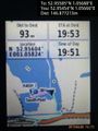
This might not be reachable for multiple reasons. Wild life disturbance is the number one obstacle. Secondly the hashpoint looks as though it's about 5 metres into a lagoon intended for the birds. If I try this one, I'll certainly respect all the guidance and signs of this nature reserve.
Expedition
- Foiled. -- Sourcerer (talk) @52.9549,1.0563 19:57, 26 June 2015 (GMT+01:00)
The lagoon was fenced off and clearly signed as a sensitive nature reserve area so that was the end of the geohashing with 94 metres still to go. In real life, this was a very attractive spot with reeds, lagoons and bird hides for twitchers. There was a fine sunset.
Photos
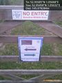
No public access. @52.9546,1.0563
Quite close. @52.9545,1.0567
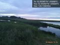
The reserve. @52.9545,1.0568
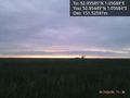
Sunset. @52.9545,1.0568


Achievements
Expeditions and Plans
| 2015-06-26 | ||
|---|---|---|
| Buffalo, New York | Pedalpusher | Middle of Mill Rd, East of Jewettville |
| Landshut, Germany | Danatar | in a wheat field between Graßlfing and Untergebraching, both of which are s... |
| Canterbury, United Kingdom | Sourcerer | 2) Cattawade Creek, River Stour, Suffolk, UK. |
| Norwich, United Kingdom | Sourcerer | 1) In a waterfowl wetland at Cley Marshes, Norfolk, UK. |
Sourcerer's Expedition Links
2015-06-25 52 1 - 2015-06-26 52 1 - 2015-06-26 51 1 - KML file download of Sourcerer's expeditions for use with Google Earth.