Difference between revisions of "2015-06-29 51 9"
From Geohashing
imported>GeorgDerReisende (create new expedition) |
imported>FippeBot m (Location) |
||
| (2 intermediate revisions by one other user not shown) | |||
| Line 1: | Line 1: | ||
| − | |||
| − | |||
| − | |||
| − | |||
| − | |||
| − | |||
| − | |||
| − | |||
| − | |||
| − | |||
{{meetup graticule | {{meetup graticule | ||
| lat=51 | | lat=51 | ||
| Line 19: | Line 9: | ||
== Location == | == Location == | ||
| − | + | ||
| + | The hash lies in the main street of Alfeld-Hörsum. | ||
== Participants == | == Participants == | ||
| − | + | ||
| − | + | [[User:GeorgDerReisende|GeorgDerReisende]] | |
== Plans == | == Plans == | ||
| − | + | ||
| + | Hitchhiking. Just starting. Arriving about 15:30. Will not wait. | ||
== Expedition == | == Expedition == | ||
| − | |||
| − | + | I left home at 11:00, started to hitchhike at 12:00. I waited at the junction of Göttingen for 90 minutes. With a lot more of cars I arrived at Hörsum at 16:40. After a short dance I found the hash. On the sidewalk at the red fence. I had a short talk with the owner of the house there. Then I went home, arrived there at 21:30. | |
| − | |||
== Photos == | == Photos == | ||
| − | |||
| − | |||
| − | |||
<gallery perrow="5"> | <gallery perrow="5"> | ||
| + | Image:2015-06-29 51 9 GeorgDerReisende 9102.jpg | Arrived. 145 m to hash. | ||
| + | Image:2015-06-29 51 9 GeorgDerReisende 9103.jpg | Found. | ||
| + | Image:2015-06-29 51 9 GeorgDerReisende 9104.jpg | Proof of dance. | ||
| + | Image:2015-06-29 51 9 GeorgDerReisende 9105.jpg | North | ||
| + | Image:2015-06-29 51 9 GeorgDerReisende 9106.jpg | South | ||
| + | Image:2015-06-29 51 9 GeorgDerReisende 9107.jpg | East | ||
| + | Image:2015-06-29 51 9 GeorgDerReisende 9110.jpg | West | ||
| + | Image:2015-06-29 51 9 GeorgDerReisende 9111.jpg | Grin | ||
| + | Image:2015-06-29 51 9 GeorgDerReisende 9112.jpg | View to the hash from the west. | ||
</gallery> | </gallery> | ||
| Line 45: | Line 41: | ||
<!-- Add any achievement ribbons you earned below, or remove this section --> | <!-- Add any achievement ribbons you earned below, or remove this section --> | ||
| − | + | {{Thumbs Up | latitude = 51 | longitude = 9 | date = 2015-06-29 | name = GeorgDerReisende }} | |
| − | |||
| − | |||
| − | + | [[Category:Expeditions]] | |
| − | |||
| − | [[Category: | ||
| − | |||
| − | |||
| − | |||
| − | |||
[[Category:Expeditions with photos]] | [[Category:Expeditions with photos]] | ||
| − | + | ||
| − | |||
| − | |||
| − | |||
| − | |||
[[Category:Coordinates reached]] | [[Category:Coordinates reached]] | ||
| − | + | {{location|DE|NI|HI}} | |
| − | |||
| − | |||
| − | |||
| − | |||
| − | |||
| − | |||
| − | |||
| − | |||
| − | |||
| − | |||
| − | |||
| − | |||
| − | |||
| − | |||
| − | |||
| − | |||
| − | |||
Latest revision as of 04:11, 15 August 2019
| Mon 29 Jun 2015 in 51,9: 51.9736694, 9.8670989 geohashing.info google osm bing/os kml crox |
Location
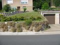
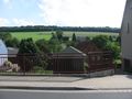
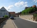
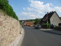
The hash lies in the main street of Alfeld-Hörsum.
Participants
Plans
Hitchhiking. Just starting. Arriving about 15:30. Will not wait.
Expedition
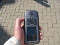
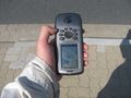
I left home at 11:00, started to hitchhike at 12:00. I waited at the junction of Göttingen for 90 minutes. With a lot more of cars I arrived at Hörsum at 16:40. After a short dance I found the hash. On the sidewalk at the red fence. I had a short talk with the owner of the house there. Then I went home, arrived there at 21:30.
Photos
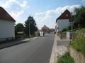
Arrived. 145 m to hash.
Found.
Proof of dance.
North
South
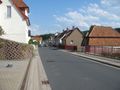
East
West
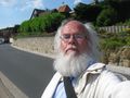
Grin
View to the hash from the west.


Achievements
GeorgDerReisende earned the Thumbs Up Geohash Achievement
|