Difference between revisions of "2015-07-06 42 -78"
imported>Pedalpusher (new report; summary, ribbons added) |
imported>FippeBot m (Location) |
||
| (One intermediate revision by one other user not shown) | |||
| Line 19: | Line 19: | ||
== Photos == | == Photos == | ||
| − | |||
<gallery perrow="5"> | <gallery perrow="5"> | ||
| − | Image: | + | Image: 2015-07-06 gps.jpg | Distance to go |
| − | Image: | + | Image: 2015-07-06 gps2.jpg | Accuracy |
| − | Image: | + | Image: 2015-07-06 hashView.jpg | View from the hash. The Cache is at the lamp post by the white car. |
| − | Image: | + | Image: 2015-07-06 stupidGrin.jpg | Standard stupid grin |
| − | Image: | + | Image: 2015-07-06 cacheSpot.jpg | Would have thought the cache would be under the lamp. |
| − | |||
| − | |||
| − | |||
</gallery> | </gallery> | ||
| Line 47: | Line 43: | ||
| − | |||
[[Category:Expeditions]] | [[Category:Expeditions]] | ||
[[Category:Coordinates reached]] | [[Category:Coordinates reached]] | ||
| + | [[Category:Expeditions with photos]] | ||
| + | {{location|US|NY|ER}} | ||
Latest revision as of 04:16, 15 August 2019
| Mon 6 Jul 2015 in 42,-78: 42.8141484, -78.7029164 geohashing.info google osm bing/os kml crox |
Location
Behind shared parking lot for the Southtowns YMCA and Ismailia Shrine Temple
Participants
Expedition
Lately, I've had a bunch of geohashes land close to me which has been a nice change. Initial plans were to ride my bike which would have been almost a duplicate of the expedition on 2015-05-28. However, there were thunderstorms in the area and I didn't want to be caught out on my bike in one of those.
With errands to run anyway, I got some grocery shopping done right after work and then drove to the hash. I pulled in the parking lot and went all the way to the back to park. My GPS picked up a signal relatively quickly, but I saw around the grassy area was a fence. I hoped the hash was close enough to the fence so I wouldn't have to jump it.
Following my GPS, I walked to the fence but saw the creek and steep ravine on the other side. There would be no jumping the fence here, and the GPS said I was over 20 feet away. I was about to call it Not Reached by Mother Nature, but tried walking further down the fence, just to see. My GPS must have picked up a better signal because the numbers started to go down! I got as close as 13 feet and I could have jumped the fence to get it closer, but decided not to, and just call it good.
Before I left for the hash, I also saw there was not only a geocache close, but it could even be in sight of the hash. Unfortunately, I was unable to find the lamp-post geocache.
I will issue a Tale of Two Challenge for The YMCA.
Photos
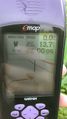
Distance to go
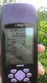
Accuracy
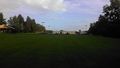
View from the hash. The Cache is at the lamp post by the white car.

Standard stupid grin
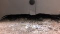
Would have thought the cache would be under the lamp.


Ribbons
This user earned the Land geohash achievement
|
