Difference between revisions of "2015-07-12 32 -110"
From Geohashing
imported>Wyle & RoadRunner (Created page with "{{meetup graticule | lat=32 | lon=-110 | date=2015-07-12 | graticule_name=Tucson | graticule_link=Tucson, Arizona}} == Location == NE of Vail, Az. == Participants == * Us...") |
imported>FippeBot m (Location) |
||
| Line 25: | Line 25: | ||
[[Category:Expeditions with photos]] | [[Category:Expeditions with photos]] | ||
[[Category:Coordinates reached]] | [[Category:Coordinates reached]] | ||
| + | {{location|US|AZ|PM}} | ||
Latest revision as of 04:20, 15 August 2019
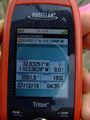
| Sun 12 Jul 2015 in Tucson: 32.0325129, -110.5363002 geohashing.info google osm bing/os kml crox |
Location
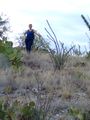
NE of Vail, Az.
Participants
Expeditions
Two possible drive routes to the location. Easiest one was barred by a locked gate at the dirt road for the gas line. Second option still got us to within a half mile and 400 foot elevation. A few rain drops the entire time and had to cover the camera on the way back. We did come across the jeep trail that was the end of route option 1 even thought we couldn't come in that way. Fun times as always. Mission Accomplished!
Tucson, Arizona
Tucson, Arizona

Tucson, Arizona


