Difference between revisions of "2015-07-22 52 1"
imported>Sourcerer m (Still foiled! [http://www.openstreetmap.org/?lat=52.45854735&lon=1.43558264&zoom=16&layers=B000FTF @52.4585,1.4356]) |
imported>Sourcerer m (→New expedition) |
||
| Line 21: | Line 21: | ||
== Expedition == | == Expedition == | ||
| − | + | This is the second time in my recent geohashing history where wet woodland has proved impassable. The track log shows my attempted approaches. From the north I was blocked by steep banks and effective fences. From the south, I was not willing to wade the shallow looking stream (the Chet) at night. A few years ago I sank up to my shoulders in soft mud in a similar location. I got out easily enough but the clean-up afterwards was not easy. Every pocket had filled with mud. And the car would get into a real mess too! | |
== Photos == | == Photos == | ||
<gallery perrow="5"> | <gallery perrow="5"> | ||
| − | |||
Image:2015-07-22_52_1_Sourcerer_1437519048467.jpg | Foiled! [http://www.openstreetmap.org/?lat=52.45855917&lon=1.43528775&zoom=16&layers=B000FTF @52.4586,1.4353] | Image:2015-07-22_52_1_Sourcerer_1437519048467.jpg | Foiled! [http://www.openstreetmap.org/?lat=52.45855917&lon=1.43528775&zoom=16&layers=B000FTF @52.4586,1.4353] | ||
| − | |||
Image:2015-07-22_52_1_Sourcerer_1437521943973.jpg | Still foiled! [http://www.openstreetmap.org/?lat=52.45854735&lon=1.43558264&zoom=16&layers=B000FTF @52.4585,1.4356] | Image:2015-07-22_52_1_Sourcerer_1437521943973.jpg | Still foiled! [http://www.openstreetmap.org/?lat=52.45854735&lon=1.43558264&zoom=16&layers=B000FTF @52.4585,1.4356] | ||
| + | Image:2015-07-22 52 1 Sourcerer.jpg | Track in Google Earth | ||
</gallery> | </gallery> | ||
| − | |||
| − | |||
| − | |||
| − | |||
| − | |||
| − | |||
| − | |||
| − | |||
| − | |||
| − | |||
| − | |||
{{Sourcerer_links | {{Sourcerer_links | ||
| prev = 2015-07-21 52 1 | | prev = 2015-07-21 52 1 | ||
| Line 50: | Line 38: | ||
}} | }} | ||
| − | |||
| − | |||
[[Category:Expeditions]] | [[Category:Expeditions]] | ||
[[Category:Expeditions with photos]] | [[Category:Expeditions with photos]] | ||
| − | [[Category:Coordinates reached]] | + | [[Category:Coordinates not reached]] |
| − | |||
Revision as of 01:01, 22 July 2015
| Wed 22 Jul 2015 in 52,1: 52.5441048, 1.4118321 geohashing.info google osm bing/os kml crox |
Location
East of Bergh Apton Hall close to the river Chet on the north bank, Norfolk, UK.
Participants
Plans
Expedition two of two spanning midnight - 2015-07-21 52 1 - 2015-07-22 52 1 - ETA 00:00.
Access to this one looks difficult. We'll see!
Expedition
This is the second time in my recent geohashing history where wet woodland has proved impassable. The track log shows my attempted approaches. From the north I was blocked by steep banks and effective fences. From the south, I was not willing to wade the shallow looking stream (the Chet) at night. A few years ago I sank up to my shoulders in soft mud in a similar location. I got out easily enough but the clean-up afterwards was not easy. Every pocket had filled with mud. And the car would get into a real mess too!
Photos
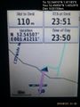
Foiled! @52.4586,1.4353
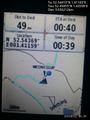
Still foiled! @52.4585,1.4356
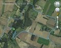
Track in Google Earth


Expeditions and Plans
| 2015-07-22 | ||
|---|---|---|
| Los Angeles, California | Erik | Turned out to be in the middle of an industrial yard in L.A. |
| Kassel, Germany | GeorgDerReisende | The hash lay on a field way beside the village Hümme. |
| Norwich, United Kingdom | Sourcerer | East of Bergh Apton Hall close to the river Chet on the north bank, Norfolk... |
| Berlin, Germany | CamelCase, Worldow | An inner courtyard of a block house. |
Sourcerer's Expedition Links
2015-07-21 52 1 - 2015-07-22 52 1 - 2015-07-23 52 1 - KML file download of Sourcerer's expeditions for use with Google Earth.