Difference between revisions of "2015-07-23 49 9"
imported>Gefrierbrand (Created page with "{{subst:Expedition |lat = 49 |lon = 09 |date = 2015-07-23 }}") |
imported>FippeBot m (Location) |
||
| (14 intermediate revisions by 2 users not shown) | |||
| Line 11: | Line 11: | ||
{{meetup graticule | {{meetup graticule | ||
| lat=49 | | lat=49 | ||
| − | | lon= | + | | lon=9 |
| date=2015-07-23 | | date=2015-07-23 | ||
| + | | graticule_name=Würzburg | ||
| + | | graticule_link=Würzburg, Germany | ||
}} | }} | ||
| − | |||
| − | |||
== Location == | == Location == | ||
| − | + | Near a skidder trail inside the [http://de.wikipedia.org/wiki/Gramschatzer_Wald Gramschatzer Wald]. | |
| − | |||
== Participants == | == Participants == | ||
| − | + | [[User:Gefrierbrand|Gefrierbrand]] | |
| − | |||
| − | == | + | == Expedition == |
| − | + | As soon as I noticed the quite close proximity of todays hashpoint to my location, I had made up my mind to go there somehow. First I considered walking and going in a straight line for the juggernaut achievement, but a quick study in Google Earth revealed that I would have to cross a highly frequented road at a very unsafe (and quite illegal) place. I therefore chose a bicycle and regular roads as the quicker and easier alternative. | |
| − | + | On my way I passed a historical marker for the [https://en.wikipedia.org/wiki/Battle_of_W%C3%BCrzburg Battle of Würzburg] in 1796 and the related "High Cross". According tho the text, the battle occurred across a 12 km long front-line and included 74000 fighting men. I was therefore surprised that the memorial cross was so plain, simple and ugly. But as the marker explained, the original one had been destroyed by a storm and the replacement one had to be replaced again as a road was built there. | |
| − | |||
| − | + | I had to go up and down again and again along the hilly terrain, and it was easy to imagine how the forests and terrain was used in the mentioned battle – however I was much more concerned with actually traveling | |
| − | + | on them than reminiscing about the past. The accumulated total height difference I had to manage was about 900 m with the steepest hill at an inclination of 54%. Walking the last few hundred meters through the forest was really easy in comparison – as was reaching the actual point as it was conveniently located in a small opening with great GPS reception. | |
== Photos == | == Photos == | ||
| Line 39: | Line 36: | ||
--> | --> | ||
<gallery perrow="5"> | <gallery perrow="5"> | ||
| + | File:2015-07-23 49 09 1.jpg| View over hilly terrain | ||
| + | File:2015-07-23 49 09 2.jpg| Historical marker for the "High Cross" | ||
| + | File:2015-07-23 49 09 3.jpg| "High Cross" | ||
| + | File:2015-07-23 49 09 4.jpg| Broken high seat | ||
| + | File:2015-07-23 49 09 5.jpg| Small trail leading towards the point | ||
| + | File:2015-07-23 49 09 6.jpg| The X marks the spot | ||
| + | File:2015-07-23 49 09 7.jpg| stupid grin™ | ||
| + | File:2015-07-23 49 09 8.jpg| Proof | ||
| + | File:2015-07-23 49 09 9.png| Heightmap (on the way home, which was easier) | ||
</gallery> | </gallery> | ||
| Line 44: | Line 50: | ||
{{#vardefine:ribbonwidth|800px}} | {{#vardefine:ribbonwidth|800px}} | ||
<!-- Add any achievement ribbons you earned below, or remove this section --> | <!-- Add any achievement ribbons you earned below, or remove this section --> | ||
| + | {{land geohash | ||
| + | | latitude = 49 | ||
| + | | longitude = 9 | ||
| + | | date = 2015-07-23 | ||
| + | | name = Gefrierbrand | ||
| + | }} | ||
| + | {{bicycle geohash | ||
| − | + | | latitude = 49 | |
| − | + | | longitude = 9 | |
| − | + | | date = 2015-07-23 | |
| − | + | | name = Gefrierbrand | |
| − | + | | distance = 9.4 km | |
| − | + | | bothways = true | |
| − | + | }} | |
| − | |||
| − | |||
| − | |||
| − | |||
[[Category:Expeditions]] | [[Category:Expeditions]] | ||
| − | |||
[[Category:Expeditions with photos]] | [[Category:Expeditions with photos]] | ||
[[Category:Expeditions with videos]] | [[Category:Expeditions with videos]] | ||
| − | |||
| − | |||
| − | |||
| − | |||
[[Category:Coordinates reached]] | [[Category:Coordinates reached]] | ||
| − | + | {{location|DE|BY|WÜ}} | |
| − | |||
| − | |||
| − | |||
| − | |||
| − | |||
| − | |||
| − | |||
| − | |||
| − | |||
| − | |||
| − | |||
| − | |||
| − | |||
| − | |||
| − | |||
| − | |||
| − | |||
Latest revision as of 04:27, 15 August 2019
| Thu 23 Jul 2015 in Würzburg: 49.8774214, 9.9706540 geohashing.info google osm bing/os kml crox |
Location
Near a skidder trail inside the Gramschatzer Wald.
Participants
Expedition
As soon as I noticed the quite close proximity of todays hashpoint to my location, I had made up my mind to go there somehow. First I considered walking and going in a straight line for the juggernaut achievement, but a quick study in Google Earth revealed that I would have to cross a highly frequented road at a very unsafe (and quite illegal) place. I therefore chose a bicycle and regular roads as the quicker and easier alternative.
On my way I passed a historical marker for the Battle of Würzburg in 1796 and the related "High Cross". According tho the text, the battle occurred across a 12 km long front-line and included 74000 fighting men. I was therefore surprised that the memorial cross was so plain, simple and ugly. But as the marker explained, the original one had been destroyed by a storm and the replacement one had to be replaced again as a road was built there.
I had to go up and down again and again along the hilly terrain, and it was easy to imagine how the forests and terrain was used in the mentioned battle – however I was much more concerned with actually traveling on them than reminiscing about the past. The accumulated total height difference I had to manage was about 900 m with the steepest hill at an inclination of 54%. Walking the last few hundred meters through the forest was really easy in comparison – as was reaching the actual point as it was conveniently located in a small opening with great GPS reception.
Photos
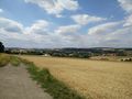
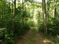
View over hilly terrain
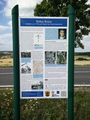
Historical marker for the "High Cross"
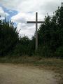
"High Cross"
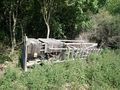
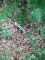
Broken high seat
Small trail leading towards the point
The X marks the spot

stupid grin™
Proof

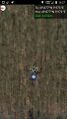
Heightmap (on the way home, which was easier)


Achievements
Gefrierbrand earned the Land geohash achievement
|
Gefrierbrand earned the Bicycle geohash achievement
|