Difference between revisions of "2015-07-24 44 -116"
imported>Eldin (add pictures) |
imported>FippeBot m (Location) |
||
| Line 36: | Line 36: | ||
[[Category:Expeditions with photos]] | [[Category:Expeditions with photos]] | ||
[[Category:Coordinates reached]] | [[Category:Coordinates reached]] | ||
| + | {{location|US|ID|PA}} | ||
Latest revision as of 01:10, 7 August 2019
| Fri 24 Jul 2015 in 44,-116: 44.0254530, -116.9337064 geohashing.info google osm bing/os kml crox |
Location
Along US-30, just east of the Oregon border.
Participants
Expedition
When I noticed how accessible this one was, I decided to drive out to it. It was a very easy hash, just parked at a closed business about a block away, and walked to the site. Didn't get a great GPS fix, but I was within the circle of uncertainty, and I did get very near to where the spot appears to be from satellite imagery.
Photos
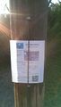
This marker was left on a pole near the hashpoint.

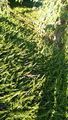
At the hash. GPS thought I was still over 20ft away, but the tree behind me appears in satelite imagery to be very nearly at the hashpoint.
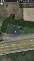
Proof that I was in the right place. One of the trees visible right by the hash in this image is the crabapple tree behind me in the previous pic.
The actual hashpoint, as near as I could figure.


Achievements
Eldin earned the Land geohash achievement
|