Difference between revisions of "2015-07-24 51 9"
imported>GeorgDerReisende (new report) |
imported>FippeBot m (Location) |
||
| (2 intermediate revisions by one other user not shown) | |||
| Line 1: | Line 1: | ||
| − | |||
| − | |||
| − | |||
| − | |||
| − | |||
| − | |||
| − | |||
| − | |||
| − | |||
| − | |||
{{meetup graticule | {{meetup graticule | ||
| lat=51 | | lat=51 | ||
| Line 19: | Line 9: | ||
== Location == | == Location == | ||
| − | + | ||
| + | The hash lay in the forest above Hann. Münden. | ||
== Participants == | == Participants == | ||
| − | + | ||
| − | + | [[User:GeorgDerReisende|GeorgDerReisende]] | |
== Plans == | == Plans == | ||
| − | + | ||
| + | Hitchhiking and walking. | ||
== Expedition == | == Expedition == | ||
| − | |||
| − | + | Like always, I prepared the expedition at home. As I started to hitchhike I noticed, that I had forgotten my notes. I thought, no problem, there is a sms service, but it was down. So I walked to the hashforest without really knewing of the exact location. At first I didn't find a way, which OpenStreetMap showed to me. It wasn't there. Then there was a thicket of young trees with nettles and thistles beyond them. There I gave up. Then I walked along the forest way to Hann. Münden and from beyond I saw, that there was no thicket at the side of the lower forest way. And I found an unknown forest way, going up the hill. While preparing the expedition I mentioned, that the hash was about 100 meters above the lower forest way. So I made some waypoints along the way and tried to find a way parallel to the forest way, but 100 meters above it. At first I walked along the new found way and as I reached the 100 m mark I tried to walk along a circle. The GPS switched to 97 m. I made ten steps, and the GPS stayed at 97 m. I made another ten steps, and the GPS stayed at 97 m. And I made another ten steps, and the GPS stayed again at 97 m, but suddenly it switched to 103 m. And there I was: on the hill, not knowing, where the hash was. Maybe here or there, somewhere beyond the young trees or within the nettles. Then I walked back to the main forest way and found another way upgoing, but I didn't make a second try. Later at home I found my notes and programmed the coordinates and found out, that the hash was only 30 meters straight along the new found forest way! Bad luck. | |
| − | |||
== Photos == | == Photos == | ||
| Line 39: | Line 29: | ||
--> | --> | ||
<gallery perrow="5"> | <gallery perrow="5"> | ||
| + | Image:2015-07-24 51 9 GeorgDerReisende 9791.jpg | the Staufenberg of Hann. Münden, the hash lay on the left side | ||
| + | Image:2015-07-24 51 9 GeorgDerReisende 9848.jpg | OpenStreetMap dreams about a forest way going down here | ||
| + | Image:2015-07-24 51 9 GeorgDerReisende 9855.jpg | unknown forest way | ||
| + | Image:2015-07-24 51 9 GeorgDerReisende 9856.jpg | begin of circle | ||
| + | Image:2015-07-24 51 9 GeorgDerReisende 9858.jpg | end of circle | ||
| + | Image:2015-07-24 51 9 GeorgDerReisende 9860.jpg | something like a dance, but in the wrong direction | ||
| + | Image:2015-07-24 51 9 GeorgDerReisende 9861.jpg | or along here? | ||
| + | Image:2015-07-24 51 9 GeorgDerReisende 9862.jpg | view down to the forest way | ||
| + | Image:2015-07-24 51 9 GeorgDerReisende 9863.jpg | view uphill, somewhere there is the hash | ||
| + | Image:2015-07-24 51 9 GeorgDerReisende 9871.jpg | another forest way uphill | ||
| + | Image:2015-07-24 51 9 GeorgDerReisende 9882.jpg | at home: track and hash | ||
</gallery> | </gallery> | ||
| Line 45: | Line 46: | ||
<!-- Add any achievement ribbons you earned below, or remove this section --> | <!-- Add any achievement ribbons you earned below, or remove this section --> | ||
| − | + | {{Blinded by Science | latitude = 51 | longitude = 9 | date = 2015-07-24 | reason = , didn't program the GPS at home and sms service was down | name = GeorgDerReisende }} | |
| − | |||
| − | |||
| − | + | == Retro expedition == | |
| − | + | ||
| − | [[ | + | On the expedition of [[2016-05-25 51 9]], after reaching the hash of the day, I walked to this place again. As thought above I found the hash at the end of the forest way. Standing there I saw the pointer dancing around. |
| − | |||
| − | < | + | <gallery perrow="5"> |
| + | Image:2015-07-24 51 9 retro GeorgDerReisende 3640.jpg | the end of the way | ||
| + | Image:2015-07-24 51 9 retro GeorgDerReisende 3641.jpg | proof | ||
| + | Image:2015-07-24 51 9 retro GeorgDerReisende 3646.jpg | dance | ||
| + | </gallery> | ||
| − | |||
[[Category:Expeditions]] | [[Category:Expeditions]] | ||
| − | + | ||
[[Category:Expeditions with photos]] | [[Category:Expeditions with photos]] | ||
| − | |||
| − | |||
| − | |||
| − | |||
| − | |||
| − | |||
| − | |||
| − | |||
[[Category:Coordinates not reached]] | [[Category:Coordinates not reached]] | ||
| − | |||
| − | |||
| − | |||
| − | |||
| − | |||
| − | |||
| − | |||
[[Category:Not reached - Technology]] | [[Category:Not reached - Technology]] | ||
| − | |||
| − | |||
| − | |||
| − | + | [[Category:Retro meetup]] | |
| + | |||
| + | [[Category:Retro coordinates reached]] | ||
| + | {{location|DE|NI|GÖ}} | ||
Latest revision as of 04:28, 15 August 2019
| Fri 24 Jul 2015 in 51,9: 51.4272551, 9.6928650 geohashing.info google osm bing/os kml crox |
Location
The hash lay in the forest above Hann. Münden.
Participants
Plans
Hitchhiking and walking.
Expedition
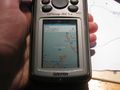
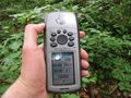
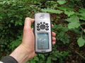
Like always, I prepared the expedition at home. As I started to hitchhike I noticed, that I had forgotten my notes. I thought, no problem, there is a sms service, but it was down. So I walked to the hashforest without really knewing of the exact location. At first I didn't find a way, which OpenStreetMap showed to me. It wasn't there. Then there was a thicket of young trees with nettles and thistles beyond them. There I gave up. Then I walked along the forest way to Hann. Münden and from beyond I saw, that there was no thicket at the side of the lower forest way. And I found an unknown forest way, going up the hill. While preparing the expedition I mentioned, that the hash was about 100 meters above the lower forest way. So I made some waypoints along the way and tried to find a way parallel to the forest way, but 100 meters above it. At first I walked along the new found way and as I reached the 100 m mark I tried to walk along a circle. The GPS switched to 97 m. I made ten steps, and the GPS stayed at 97 m. I made another ten steps, and the GPS stayed at 97 m. And I made another ten steps, and the GPS stayed again at 97 m, but suddenly it switched to 103 m. And there I was: on the hill, not knowing, where the hash was. Maybe here or there, somewhere beyond the young trees or within the nettles. Then I walked back to the main forest way and found another way upgoing, but I didn't make a second try. Later at home I found my notes and programmed the coordinates and found out, that the hash was only 30 meters straight along the new found forest way! Bad luck.
Photos
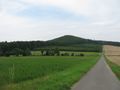
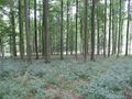
the Staufenberg of Hann. Münden, the hash lay on the left side
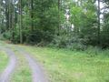
OpenStreetMap dreams about a forest way going down here
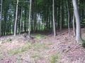
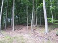
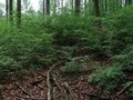
unknown forest way

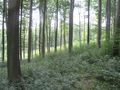
begin of circle

end of circle

something like a dance, but in the wrong direction
or along here?
view down to the forest way
view uphill, somewhere there is the hash
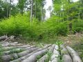
another forest way uphill
at home: track and hash


Achievements
GeorgDerReisende earned the Blinded by Science Consolation Prize
|
Retro expedition
On the expedition of 2016-05-25 51 9, after reaching the hash of the day, I walked to this place again. As thought above I found the hash at the end of the forest way. Standing there I saw the pointer dancing around.
the end of the way
proof
dance


