Difference between revisions of "2015-07-24 52 9"
From Geohashing
imported>Fippe ({{location|DE|NI|H}} Category:Expeditions by Fippe) |
m (Format) |
||
| Line 30: | Line 30: | ||
==Achievements== | ==Achievements== | ||
| + | {{#vardefine:ribbonwidth|100%}} | ||
{{land geohash|latitude=52|longitude=9|date=2015-07-24|name=[[User:Fippe|Fippe]]|image=2015-07-24 52 09 06 Landscape.jpg}} | {{land geohash|latitude=52|longitude=9|date=2015-07-24|name=[[User:Fippe|Fippe]]|image=2015-07-24 52 09 06 Landscape.jpg}} | ||
Revision as of 17:35, 13 October 2020
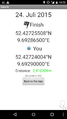
| Fri 24 Jul 2015 in Hannover: 52.4272551, 9.6928650 geohashing.info google osm bing/os kml crox |
Location
The Geohash is located on a field in Hannover-Vinnhorst near the Mittelland Canal.
Participants
Plans
Get near the place by tram, then walk.
Expedition
I took tram 6 all the way to it's endpoint, Nordhafen. From there, I started walking. Google Maps suggested a way that hardly was one, which got me wondered how Google knows about this way in the first place. Anyhow, I soon reached the coordinates, where I created the required proof and headed back.
Photos
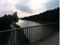
The Midland Canal
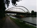
A ship on the canal, in the background the bridge I stood on for the first picture
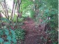
Google Maps knows this “way”. I am impressed, yet concerned.
The Geohash
Proof
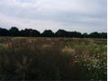
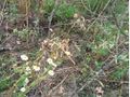
Landscape at the Hash


Achievements
Fippe earned the Land geohash achievement
|