Difference between revisions of "2015-07-27 64 27"
imported>Nebini (Content) |
imported>FippeBot m (Location) |
||
| Line 35: | Line 35: | ||
[[Category:Expeditions with photos]] | [[Category:Expeditions with photos]] | ||
[[Category:Coordinates reached]] | [[Category:Coordinates reached]] | ||
| + | {{location|FI|05}} | ||
Latest revision as of 04:32, 15 August 2019
| Mon 27 Jul 2015 in 64,27: 64.8278308, 27.9195462 geohashing.info google osm bing/os kml crox |
Location
In Puolanka, a few hundred meters from the road.
Participants
Plans
Take a minor detour when driving from Kuusamo to Kajaani to visit the hash.
Expedition
It was late evening when I visited Puolanka center. All shops were closed and only few locals walked by while I prepared the GPS for the expedition.
Another standard-grade forest hash for me. A logging path led straight to the hashpoint from the place where the car was parked. There were many Russula- and Boletaceae-mushrooms on the forest floor and of course aggressive mosquitoes.
A few kilometers from the hashpoint lies the tallest undisturbed waterfall in Finland. The waterfall is called Hepoköngäs. I met a couple looking for cloudberries on the nearby swamps. They did not manage to find any.
Photos
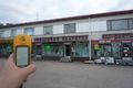
The Puolanka "shopping center"
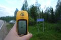
Just before leaving to the forest.

Reached
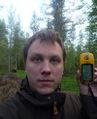
Grin
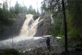
Hepoköngäs waterfall


