Difference between revisions of "2015-08-06 54 -2"
From Geohashing
imported>Angel ([live picture] Obligatory non-selfie [http://www.openstreetmap.org/?lat=54.04010000&lon=-2.78025000&zoom=16&layers=B000FTF @54.0401,-2.7802]) |
imported>FippeBot m (Location) |
||
| (3 intermediate revisions by 2 users not shown) | |||
| Line 1: | Line 1: | ||
| − | + | [[Image:{{{image|2015-08-06_54_-2_angel_1438861747082.jpg}}}|thumb|left]] | |
| − | |||
| − | |||
| − | |||
| − | |||
| − | |||
| − | |||
| − | |||
{{meetup graticule | {{meetup graticule | ||
| lat=54 | | lat=54 | ||
| Line 19: | Line 12: | ||
== Location == | == Location == | ||
| − | + | Looks like it's in Lancaster Leisure Park, outside the Lancaster Brewery visitor centre. | |
== Participants == | == Participants == | ||
| − | + | * [[User:Angel|Angel]] ([[User talk:Angel|talk]]) | |
| − | + | * Angel's housemate Twilight | |
== Plans == | == Plans == | ||
| − | + | Walk up, see how close we can get, stop for a sandwich on the way back, and rush back to wotk before 2. | |
== Expedition == | == Expedition == | ||
| − | + | ||
| + | *Sorry the page is a bit rough. I still need 4 hours work on my timesheet today, and have friends coming around in 5. I'll try to remember to do a proper report later. -- [[User:Angel|Angel]] ([[User talk:Angel|talk]]) [http://www.openstreetmap.org/?lat=54.04689848&lon=-2.77723998&zoom=16&layers=B000FTF @54.0469,-2.7772] 08:04, 6 August 2015 (EDT) | ||
| + | |||
| + | * Just like we planned, really. Sitting in the Pavillion café now, just about to head home [[User:Angel|Angel]] ([[User talk:Angel|talk]]) 08:57, 6 August 2015 (EDT) | ||
== Tracklog == | == Tracklog == | ||
| − | + | * Available from [https://www.endomondo.com/workouts/576170326/3871875 Endomondo] | |
== Photos == | == Photos == | ||
| Line 50: | Line 46: | ||
{{#vardefine:ribbonwidth|800px}} | {{#vardefine:ribbonwidth|800px}} | ||
<!-- Add any achievement ribbons you earned below, or remove this section --> | <!-- Add any achievement ribbons you earned below, or remove this section --> | ||
| + | Walking geohash, drag-along. Could have managed Tron if I'd thought about it ten minutes sooner. | ||
<!-- =============== USEFUL CATEGORIES FOLLOW ================ | <!-- =============== USEFUL CATEGORIES FOLLOW ================ | ||
Delete the next line ONLY if you have chosen the appropriate categories below. If you are unsure, don't worry. People will read your report and help you with the classification. --> | Delete the next line ONLY if you have chosen the appropriate categories below. If you are unsure, don't worry. People will read your report and help you with the classification. --> | ||
| − | |||
| − | |||
| − | |||
| − | |||
| − | |||
| − | |||
| − | |||
| − | |||
| − | |||
[[Category:Expeditions]] | [[Category:Expeditions]] | ||
| − | |||
[[Category:Expeditions with photos]] | [[Category:Expeditions with photos]] | ||
| − | |||
| − | |||
| − | |||
| − | |||
| − | |||
[[Category:Coordinates reached]] | [[Category:Coordinates reached]] | ||
| − | + | {{location|GB|ENG|LAN}} | |
| − | |||
| − | |||
| − | |||
| − | |||
| − | |||
| − | |||
| − | |||
| − | |||
| − | |||
| − | |||
| − | |||
| − | |||
| − | |||
| − | |||
| − | |||
| − | |||
| − | |||
Latest revision as of 04:42, 15 August 2019

| Thu 6 Aug 2015 in 54,-2: 54.0400912, -2.7803015 geohashing.info google osm bing/os kml crox |
Location
Looks like it's in Lancaster Leisure Park, outside the Lancaster Brewery visitor centre.
Participants
Plans
Walk up, see how close we can get, stop for a sandwich on the way back, and rush back to wotk before 2.
Expedition
- Sorry the page is a bit rough. I still need 4 hours work on my timesheet today, and have friends coming around in 5. I'll try to remember to do a proper report later. -- Angel (talk) @54.0469,-2.7772 08:04, 6 August 2015 (EDT)
- Just like we planned, really. Sitting in the Pavillion café now, just about to head home Angel (talk) 08:57, 6 August 2015 (EDT)
Tracklog
- Available from Endomondo
Photos

Me and Twilight, on the way @54.0428,-2.7858

Success! @54.0400,-2.7800
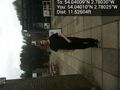
Obligatory non-selfie @54.0401,-2.7802


Achievements
Walking geohash, drag-along. Could have managed Tron if I'd thought about it ten minutes sooner.