Difference between revisions of "2015-08-10 52 -3"
imported>Huinesoron (Categorising; no report yet.) |
imported>FippeBot m (Location) |
||
| (2 intermediate revisions by one other user not shown) | |||
| Line 1: | Line 1: | ||
| − | |||
| − | |||
| − | + | [[Image:{{{image|2015-08-10 52 -3 ThisIsAllIGet.jpg}}}|thumb|left]] | |
| − | + | ||
| − | |||
| − | |||
{{meetup graticule | {{meetup graticule | ||
| lat=52 | | lat=52 | ||
| Line 31: | Line 27: | ||
== Expedition == | == Expedition == | ||
| − | Apparently they made it! I | + | Apparently they made it! |
| + | |||
| + | As told to me, the trip involved driving to the [https://en.wikipedia.org/wiki/Centre_for_Alternative_Technology Centre for Alternative Technology] (CAT), driving up the side-access road, driving back ''down'' the side-access road, parking... and then walking right back ''up'' the side-access road again. A cut over a gate led into the hash-field, which was (according to Google Maps) mostly ploughed or grass. | ||
| + | |||
| + | According to my puppets, it was mostly bracken higher than their heads. Them's the breaks. | ||
| + | |||
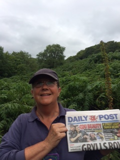
| + | The single picture I've been given constitutes proof of date - the local newspaper - and, if you squint ''really hard'', location as well. On the horizon, near the right-hand side of the picture, just to the left of that tall plant that's one of the few non-ferns in the image, you can ''just'' make out the top blade of CAT's wind turbine. It was one of the first wind turbines I ever saw, actually, so it's fitting that it serves to prove the location here. (Uh, you may have to zoom in to see it...! ^_^) | ||
== Photos == | == Photos == | ||
| Line 38: | Line 40: | ||
--> | --> | ||
<gallery perrow="5"> | <gallery perrow="5"> | ||
| + | Image:2015-08-10 52 -3 ThisIsAllIGet.jpg | Proof of field. | ||
</gallery> | </gallery> | ||
== Achievements == | == Achievements == | ||
{{#vardefine:ribbonwidth|800px}} | {{#vardefine:ribbonwidth|800px}} | ||
| − | + | ||
| + | {{Puppet Master Geohash | ||
| + | | latitude = 52 | ||
| + | | longitude = -3 | ||
| + | | date = 2015-08-10 | ||
| + | | puppet = his parents | ||
| + | | name = [[User:Huinesoron|Huinesoron]] ([[User talk:Huinesoron|talk]]) | ||
| + | | image = 2015-08-10 52 -3 ThisIsAllIGet.jpg | ||
| + | }} | ||
[[Category:Expeditions]] | [[Category:Expeditions]] | ||
| − | + | ||
| − | |||
[[Category:Expeditions with photos]] | [[Category:Expeditions with photos]] | ||
| − | + | ||
| − | |||
| − | |||
[[Category:Coordinates reached]] | [[Category:Coordinates reached]] | ||
| + | {{location|GB|CYM|POW}} | ||
Latest revision as of 04:45, 15 August 2019
| Mon 10 Aug 2015 in 52,-3: 52.6216868, -3.8403157 geohashing.info google osm bing/os kml crox |
Location
The Mid-Wales graticule is full of hills and trees, but while today's hashpoint is on a hill, it is not in trees! More importantly, it's right next to the easily-accessible Centre for Alternative Technology.
Participants
- Huinesoron's parents (and their dog).
- No actual Geohashers! Huinesoron (talk) is going for a Puppet Master Geohash Achievement.
Plans
My parents are in Wales for their summer holiday, and I've decided to give them something to do. ^_^ I'm keeping an eye on the hashes around them, and when one comes up nearby, I give them their instructions. I was actually there with them for one potential hash (see 2015-07-29 52 -3 for how that didn't happen), but now I'm back home in London East, United Kingdom, so it's puppeteering for me.
Expedition
Apparently they made it!
As told to me, the trip involved driving to the Centre for Alternative Technology (CAT), driving up the side-access road, driving back down the side-access road, parking... and then walking right back up the side-access road again. A cut over a gate led into the hash-field, which was (according to Google Maps) mostly ploughed or grass.
According to my puppets, it was mostly bracken higher than their heads. Them's the breaks.
The single picture I've been given constitutes proof of date - the local newspaper - and, if you squint really hard, location as well. On the horizon, near the right-hand side of the picture, just to the left of that tall plant that's one of the few non-ferns in the image, you can just make out the top blade of CAT's wind turbine. It was one of the first wind turbines I ever saw, actually, so it's fitting that it serves to prove the location here. (Uh, you may have to zoom in to see it...! ^_^)
Photos
Achievements
Huinesoron (talk) earned the Puppet Master Geohash achievement
|

