Difference between revisions of "2015-08-12 37 -122"
imported>Anthony (create) |
imported>Anthony (add KMZ) |
||
| Line 29: | Line 29: | ||
I left work and drive towards the site. I wandered around on foot looking for the exact point, and ended up climbing the ridge and wandering around before coming back to the clump of trees where the actual point was. | I left work and drive towards the site. I wandered around on foot looking for the exact point, and ended up climbing the ridge and wandering around before coming back to the clump of trees where the actual point was. | ||
| + | KMZ file of expedition [https://drive.google.com/file/d/0BwMosRNdZnENdnV0U2pnM2g0SWc/view here], including a detour to an old jobsite. | ||
== Photos == | == Photos == | ||
| Line 40: | Line 41: | ||
</gallery> | </gallery> | ||
| − | |||
| − | |||
| − | |||
| − | |||
| − | |||
[[Category:Expeditions]] | [[Category:Expeditions]] | ||
Revision as of 20:14, 13 August 2015
| Wed 12 Aug 2015 in 37,-122: 37.6471822, -122.4703702 geohashing.info google osm bing/os kml crox |
Location
On the San Andreas Fault, in an open space on the South San Francisco/Pacifica border just east of Skyline Boulevard (Highway 35).
Participants
Plans
Almost none. I checked the day's hashpoint, and saw that it was reachable during lunch, and near a former jobsite of mine.
Expedition
I left work and drive towards the site. I wandered around on foot looking for the exact point, and ended up climbing the ridge and wandering around before coming back to the clump of trees where the actual point was.
KMZ file of expedition [https://drive.google.com/file/d/0BwMosRNdZnENdnV0U2pnM2g0SWc/view here], including a detour to an old jobsite.
Photos
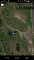
View from Carter Street towards hashpoint. It's in that clump of trees sticking up above the ridge.
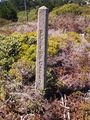
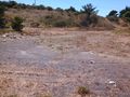
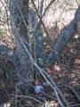
Wandering nearby, I found this. It's basically on the San Andreas Fault.
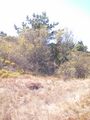
Hashopint is in this clump of trees.
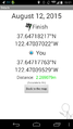
Screenshot of Geohash Droid.
Another screenshot of Geohash Droid.
Screenshots taken in the same place I took this picture.


