Difference between revisions of "2015-08-14 50 8"
imported>Sourcerer m (→removed new report category) |
imported>FippeBot m (Location) |
||
| Line 40: | Line 40: | ||
[[Category:Expeditions with photos]] | [[Category:Expeditions with photos]] | ||
[[Category:Coordinates reached]] | [[Category:Coordinates reached]] | ||
| + | {{location|DE|HE|WI}} | ||
Latest revision as of 04:47, 15 August 2019
| Fri 14 Aug 2015 in 50,8: 50.0077248, 8.3059386 geohashing.info google osm bing/os kml crox |
Location
on a playground in Mainz-Kostheim
Participants
Plans
Go to the hash by bike, take the train back from Mainz.
Expedition
I once again took my bike out for a tour to the geohash. Starting at home in Darmstadt I drove via Groß-Gerau, Trebur and Mainz-Ginsheim, -Gustavsburg to the hash location in Mainz-Kostheim. Mainz-Kostheim, despite of what the name suggests, actually now belongs to the city of Wiesbaden. For further information on why this is so, check https://en.wikipedia.org/wiki/Mainz-Kostheim. Shortly after noon I reached the hashpoint on a playground, where I had a break, left a chalk mark and took some photos.
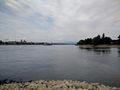
As the weather was fair and I still had plenty of time, I decided not to drive home immediately but to explore the area bit. I quickly came down to the bank of the Rhine with a great view towards the city of Mainz. Following the Rhine river, I approached the confluence of the Main and the Rhine, at the "Mainspitze". First, I was on the opposite side of the Main but going to the actual "Mainspitze" was not too far, so I also went there and took more photos.
For the way back I drove to Bischofsheim and took the train back to Darmstadt. The total biking distance was about 53km.
Photos
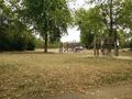
hashpoint on the playground
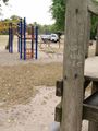
chalk mark at the playground

GPS proof
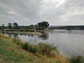
Looking at the "Mainspitze", confluence of the Main river with the Rhine
Looking at Mainz from the "Mainspitze"
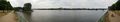
Panoramic view across the Rhine onto Mainz


