2015-08-15 52 1
From Geohashing
Revision as of 23:04, 14 August 2015 by imported>Sourcerer ([retro picture] Dung heap. [http://www.openstreetmap.org/?lat=52.41345406&lon=1.49285853&zoom=16&layers=B000FTF @52.4135,1.4929])
| Sat 15 Aug 2015 in 52,1: 52.4134064, 1.4930074 geohashing.info google osm bing/os kml crox |
Location
Close to a public footpath south of Ilketshall Hall, Ilketshall Saint Andrew, Suffolk, UK.
Participants
Plans
Expedition two of two spanning midnight - 2015-08-14 52 1 - 2015-08-15 52 1 - ETA 00:00.
Sunday and Monday are in the sea AGAIN!
Expedition
- Arrived. -- Sourcerer (talk) @52.4134,1.4930 00:00, 15 August 2015 (GMT+01:00)
Photos
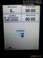
Proof. @52.4134,1.4930
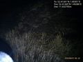
Dung heap. @52.4135,1.4929


Achievements
Expeditions and Plans
| 2015-08-15 | ||
|---|---|---|
| Mannheim, Germany | DODO | A forest between Altrip and Waldsee. |
| Kassel, Germany | GeorgDerReisende | The hash lay south of Immenhausen in a field. |
| Norwich, United Kingdom | Sourcerer | Close to a public footpath south of Ilketshall Hall, Ilketshall Saint Andre... |
| Manchester, United Kingdom | Yewbarrow | Woodend Lane, between Warrington and Partington. Looks to be just a few met... |
| Rovaniemi, Finland | isopekka | In Rovaniemi, in Hietavaara. |
Sourcerer's Expedition Links
2015-08-14 52 1 - 2015-08-15 52 1 - 2015-08-18 52 1 - KML file download of Sourcerer's expeditions for use with Google Earth.